What Is a Weather Front? Types, Examples & Weather Impact
What is a weather front, and how can it turn a calm day into a stormy one? Weather can feel unpredictable, but there’s actually a clear reason behind it. This article will help you make sense of those sudden changes in an easy, relatable way. Discover now!
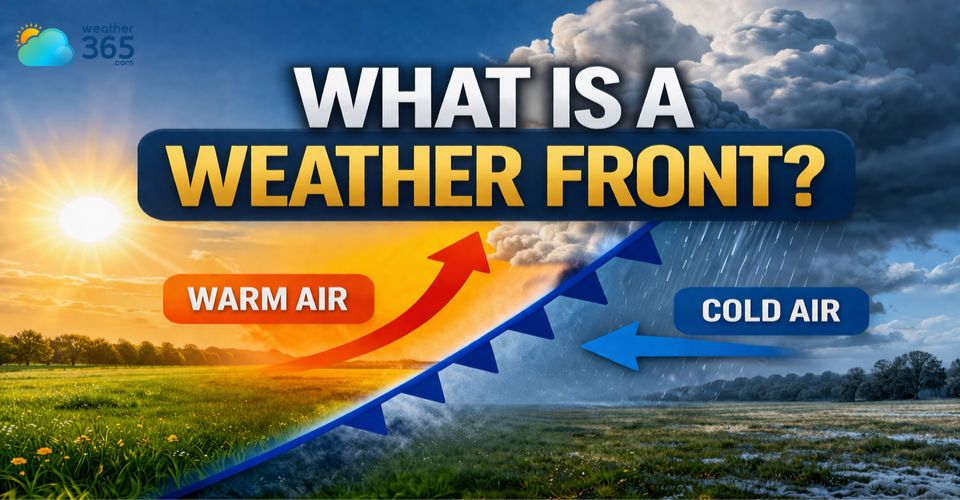
What is a weather front?
What Is A Weather Front?
So, what is a weather front in simple terms? You can think of it as a boundary or meeting line between two different air masses.
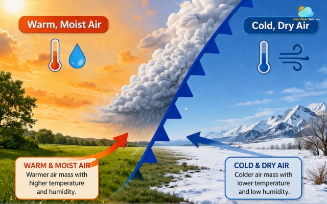
These air masses often have clear contrasts in temperature, humidity, and density. One might be warm and moist, while the other is cold and dry.
Air masses usually have different temperatures
When they come into contact, the atmosphere reacts, and that’s when weather starts to change.
Instead of blending smoothly, these air masses tend to push against each other.
Warm air, being lighter, usually rises above cold air, while cold air tends to sink and push forward.
This movement creates instability in the atmosphere, leading to cloud formation, precipitation, and sometimes strong winds or storms.
That’s why many noticeable weather events, like sudden rain or a temperature drop are linked to a passing front.
Types of weather fronts
There are four main types of weather fronts you’ll typically hear about:
warm front
cold front
stationary front
occluded front
Each one behaves differently depending on how the air masses interact. Some bring gentle, long-lasting rain, while others can trigger short but intense storms.
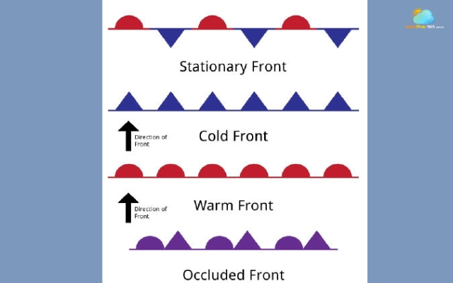
Four types of weather front
A bit of history
The idea of weather fronts was developed in the early 1900s by a group of Norwegian meteorologists who were trying to better understand how large-scale weather systems work.
They noticed patterns in how air masses move and interact, and introduced the concept of “fronts” as boundaries, similar to battle lines between opposing forces.
This breakthrough completely changed how we study and predict weather.
Today, weather fronts are a fundamental part of meteorology, helping forecasters explain everything from daily temperature changes to major storm systems.
Warm Front
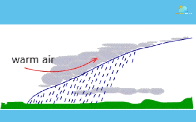
A warm front forms when a mass of warm air slowly moves toward a colder air mass and begins to slide over it.
Because warm air is lighter, it doesn’t push the cold air away; instead, it gently rises above it.
This gradual movement is what makes warm fronts feel less dramatic but more prolonged compared to other types.
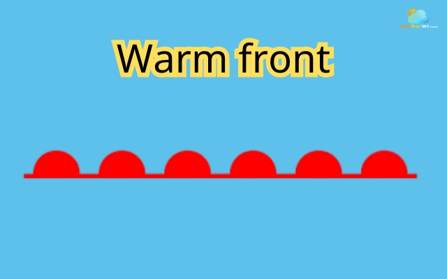
Symbol of warm front
As the warm air rises, it cools and condenses, creating layers of clouds that thicken over time.
You might first notice high, thin clouds, which slowly turn into thicker gray skies.
Eventually, this often leads to steady, light precipitation such as drizzle or continuous rain rather than sudden downpours.
Warm front can bring drizzles
One of the key signs of a warm front is how gradual everything feels.
Temperatures slowly increase, humidity rises, and the weather transitions smoothly instead of changing abruptly.
After the front passes, the air typically becomes warmer and more humid than before.
Warm fronts are important because they often signal a shift to a more stable but cloudier weather pattern.
While they don’t usually bring severe storms, they can affect large areas for an extended period, making them a key feature in many regional weather systems.
Read more: What is a warm front?
Cold Front
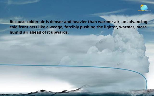
A cold front forms when a colder, denser air mass moves in and pushes underneath a warmer air mass.
Because cold air is heavier, it acts like a wedge, forcing the warm air to rise quickly into the atmosphere.
This fast upward movement is what makes cold fronts much more intense and noticeable than warm fronts.
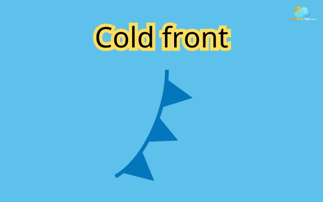
Symbol of cold front
As the warm air rises rapidly, it cools and condenses, often forming tall clouds like cumulonimbus.
These clouds are associated with short but powerful weather events - think heavy rain, thunderstorms, strong winds, and even hail or tornadoes in extreme cases.
Cold front can bring sudden and drastic changes to the weather
One key thing about cold fronts is how quickly they change the weather. Unlike the gradual transition of a warm front, a cold front can pass through an area in just a few hours, bringing a sudden drop in temperature and a noticeable shift in wind direction.
After the front moves on, the difference is clear: the air becomes cooler, drier, and the sky often clears up quite fast.
This sharp contrast is exactly why cold fronts are often linked to dramatic weather changes.
Read more: What is a cold front?
Stationary Front
A stationary front forms when a warm air mass and a cold air mass meet, but neither one is strong enough to push the other away.
Instead of moving forward like warm or cold fronts, this boundary basically stalls in place, sometimes for several days.
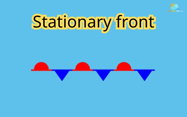
Symbol of stationary front
To picture it more clearly, imagine two forces facing each other but stuck in a standstill.
The warm air tries to move forward, while the cold air resists. As a result, the front stays almost motionless, lingering over the same region.
Because it doesn’t move much, a stationary front often brings long-lasting and repetitive weather conditions.
You’ll typically see cloudy skies, steady rain, or light showers that seem to come and go without fully clearing up.
In some cases, this persistent rainfall can last for days and may even lead to localized flooding.
Stationary front can bring light to moderate precipitation
Another thing to notice is that weather along a stationary front can feel uneven.
On one side, it might be warmer and more humid, while just a short distance away, the air feels cooler and drier.
This contrast can remain in place until one air mass finally gains strength and pushes the front to move again.
So, if you ever experience a stretch of dull, gray weather that just won’t change, there’s a good chance a stationary front is sitting nearby, quietly shaping the conditions day after day.
Occluded Front
An occluded front forms when a faster-moving cold front catches up with a slower warm front.
When this happens, the warm air that was originally between them gets lifted completely off the ground, leaving two cooler air masses at the surface.
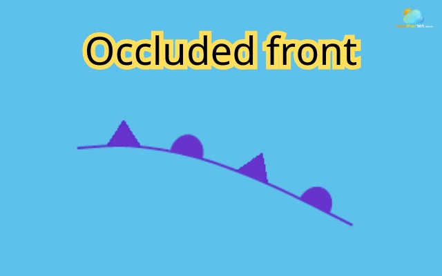
Symbol of occluded front
To picture it simply, imagine a cold front “overtaking” a warm front. As it pushes forward, it forces the warm air upward, cutting it off from the surface
This is exactly what the term occluded means: blocked or lifted away.
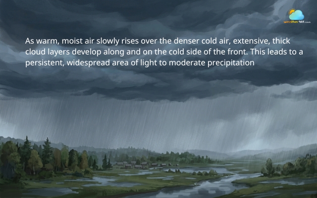
Because this type of front is a combination of both warm and cold fronts, the weather it brings is often more complex and mixed.
You might experience thick cloud cover, steady rain, and sometimes even thunderstorms or stronger winds, depending on how unstable the air is.
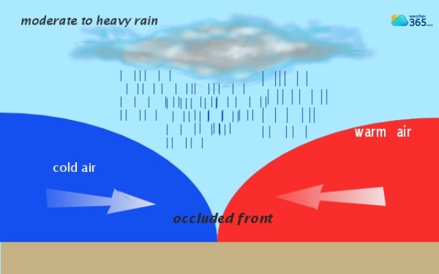
Occluded front is a combination of both warm and cold fronts
Another interesting point is that occluded fronts are usually linked to mature storm systems.
At this stage, the system has already developed and is starting to weaken as the warm air gets pushed upward and cut off from the surface.
So, while occluded fronts may sound complicated, the idea is actually quite straightforward: it’s what happens when different fronts interact and “merge,” creating layered air and often unsettled, cloudy weather.
Troughs
A trough is not exactly a weather front, but it’s closely related and often shows up alongside them.
In simple terms, a trough is an elongated area of relatively low atmospheric pressure, stretching out like a dip or “valley” in the atmosphere.
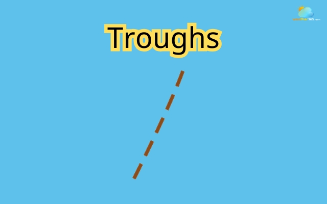
Symbol of troughs
To visualize it, imagine a weather map where pressure lines bend into a “V” or “U” shape - this dip is the trough.
It doesn’t form a closed circle like a typical low-pressure system, but it still marks a zone where the air is less stable.
The dip of the U-shape is the trough
What makes troughs important is how they affect air movement. Air tends to converge and rise within a trough, and when air rises, it cools and forms clouds.
That’s why troughs are often linked to cloudy skies, showers, and sometimes thunderstorms.
You can think of a trough as a signal that the weather may become more unsettled.
Even though not every trough leads to heavy rain, it usually increases the chances of changing conditions, like a quick burst of precipitation followed by clearer skies.
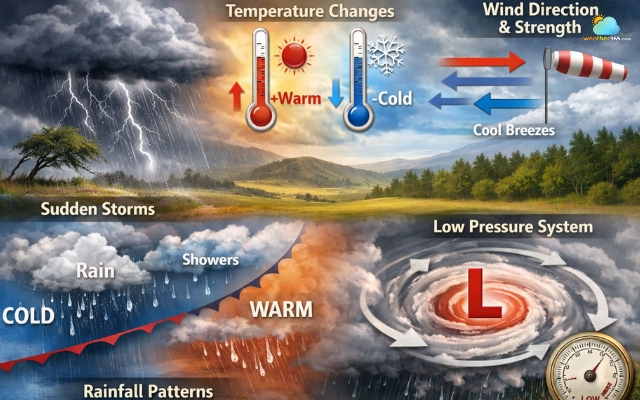
Why do weather fronts matter?
Weather fronts matter because they are behind most of the changes you notice in daily weather.
When a front moves through an area, it acts like a signal that something is about to shift, whether it’s temperature, wind, or precipitation.
Sudden storms
One of the most obvious effects is sudden storms.
Cold fronts, for example, can trigger quick and intense thunderstorms, while other fronts may bring steady rain that lasts for hours or even days.
If you’ve ever seen dark clouds roll in unexpectedly, there’s a good chance a front was involved.
Temperature changes
Fronts are also responsible for temperature changes.
A warm front can slowly raise temperatures and make the air feel more humid, while a cold front can bring a sharp drop, sometimes within just a few hours.
This is why the weather can feel completely different from one day to the next.
Wind direction and strength
Another important impact is wind direction and strength. As fronts pass, winds often shift and can become stronger.
This happens because the boundary between air masses disrupts the balance of the atmosphere, causing air to move more actively.
Rainfall patterns
They also shape rainfall patterns. Some fronts bring light, continuous rain, while others lead to heavy downpours or even severe weather.
Over time, these patterns play a big role in water supply, agriculture, and even natural disasters like floods.
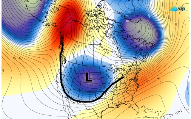
Low-pressure system
Most importantly, weather fronts are closely tied to low-pressure systems, where air is rising and conditions are more unstable.
This is why meteorologists pay close attention to fronts when making forecasts, they help predict when and where weather will change.
The weather front significantly affect weather changes
In conclusion
What is a weather front and why should you care? Because it explains so many everyday weather changes. Once you know how fronts work, it becomes much easier to understand forecasts and plan your day with confidence, no matter what’s coming next.
Frequently Asked Questions (FAQs)
If you want to read a weather front, it’s crucial to learn the weather symbols. Fortunately, we have full guide in symbols on weather!
Related post

What Is Barometric Pressure? Simple Explanation for Beginners

What Is Air Pressure? Understanding Atmospheric Pressure

0 Comment
Leave a comment
Your email address will not be published. Required fields are marked *