What is a Warm Front? Identifying Clouds and Pressure Changes
What is a warm front, and why does the sky turn gray for hours with no clear break? If you’ve ever planned your day around weather that just won’t clear up, this slow-moving system might be the reason. Let’s break down what’s really happening above you!

What is a warm front
What is a warm front?
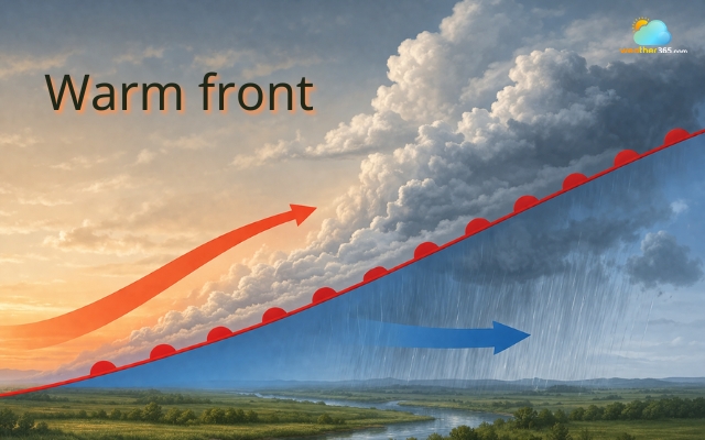
A warm front is the boundary where a mass of warm air advances into an area of cooler air.
Instead of pushing the cold air away, the warmer, lighter air slowly slides up and over it, creating a gentle transition between the two air masses.
This happens because warm air is less dense than cold air, so it cannot force its way underneath.
Instead, it rises gradually along a shallow slope, a process often called overrunning.
As this warm air lifts, it cools and condenses, forming widespread clouds and precipitation over a large area.
Lifting warm air forms widespread clouds
What makes a warm front different from more dramatic systems (like cold fronts) is its slow and steady nature.
The boundary can stretch for hundreds of kilometers, and the weather changes it brings tend to develop gradually rather than suddenly.
In simple terms, a warm front is a transition zone where warmer, often more humid air replaces cooler air, reshaping the atmosphere step by step.
Origin of a warm front
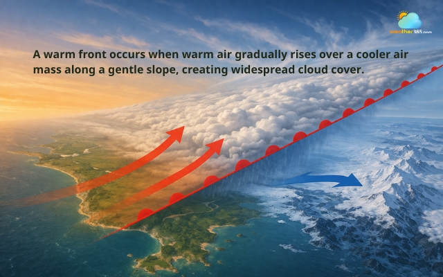
Warm fronts usually form where different air masses meet, especially when warm tropical air moves toward cooler polar air.
This contrast in temperature and density is what sets the whole process in motion.
As the warm air approaches, it begins to rise over the colder air along a very gentle, extended slope.
Because this slope is much less steep than in a cold front, the lifting process is slower and spreads across a wider region.
This is why warm fronts are often associated with broad cloud systems and prolonged weather changes rather than short, intense events.
Warm fronts form where different air masses meet
At the same time, several atmospheric changes occur:
Air pressure gradually drops as the system approaches
Temperature slowly increases due to the incoming warm air
Moisture in the rising air leads to layered cloud formation
Warm fronts are also closely linked to low-pressure systems, where large-scale air circulation helps push the warm air forward.
Because they move more slowly than cold fronts, they can sometimes be overtaken, leading to more complex systems like occluded fronts.
Overall, the origin of a warm front lies in the meeting of contrasting air masses, but its defining feature is how gently and gradually that interaction unfolds across the sky.
Weather conditions with a warm front
One of the most recognizable things about a warm front is how gradual and drawn-out the weather changes feel.
Instead of sudden storms, everything seems to build slowly, clouds thicken over time, the sky turns gray, and rain can last for hours without really stopping.
This happens because warm air rises gently over cold air, creating widespread and steady conditions across a large area.
Phases of a warm front
Before the front arrives
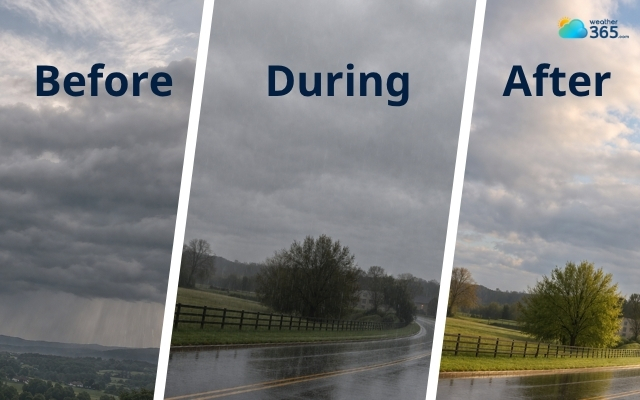
Long before the warm front actually reaches your location, the atmosphere already starts to shift.
You might notice the sky becoming increasingly cloudy, starting from thin, high clouds and slowly turning thicker and lower.
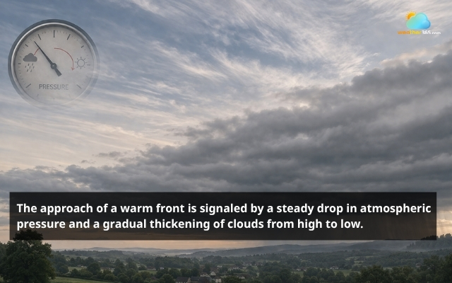
Sky becomes increasingly cloudy before the front arrives
At the same time, atmospheric pressure begins to drop gradually, which is a classic signal that a front is approaching.
As the clouds continue to build, light, steady rain or drizzle often begins, even when the front is still quite far away.
This stage can feel frustrating because the weather doesn’t change dramatically; it just becomes duller, grayer, and more persistent.
As the front passes
When the warm front moves directly over an area, the weather typically reaches its most stable, but also most overcast phase.
The sky is usually fully covered with thick clouds, creating continuous gray conditions with little to no sunlight.
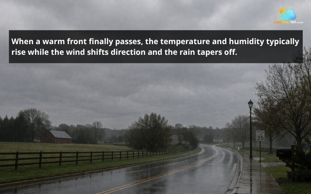
Overcast sky as the warm fronts passes
Rain during this time is usually light to moderate but steady, rather than intense.
It can last for long periods, reducing visibility and making everything feel damp and slow-moving.
Unlike thunderstorms from cold fronts, this kind of rain rarely feels dramatic; it’s more like a long, uninterrupted stretch of wet weather.
After the front passes
Once the warm front has moved through, the atmosphere shifts again, but this time in a more noticeable way.
The air becomes warmer and more humid, since the warm air mass has fully replaced the colder one.
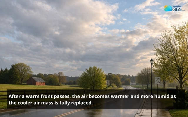
The air becomes warmer and more humid after warm front passes
Rain usually tapers off or stops, and while the sky may stay cloudy for a while, clouds often begin to break up slowly.
In some cases, clearer conditions follow, bringing a more comfortable and stable atmosphere.
Overall, the passage of a warm front leaves behind a feeling of milder, softer weather, even if it takes time for the sky to fully clear.
Cloud Types Related To A Warm Front
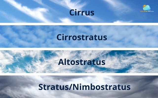
One of the most interesting signs of a warm front is the predictable sequence of clouds that appear as it approaches, often described as a “cloud parade.”
This happens because warm air rises gradually over cold air, creating layers of clouds at different heights in the atmosphere.
Different types of clouds
Cirrus
Typically, the first clouds you’ll notice are high-level cirrus clouds: thin, wispy streaks that may look harmless at first.
But they are actually an early signal that a weather system is on the way.
Cirrostratus
As the warm front gets closer, these clouds spread and thicken into cirrostratus, forming a light veil across the sky and sometimes creating a halo around the sun or moon.
Altostratus
As the lifting of warm air continues, the cloud layer becomes lower and denser.
You’ll start to see altostratus clouds, which appear as a gray or bluish sheet that can block out sunlight.
This stage usually means precipitation is getting closer.
Stratus/Nimbostratus
Eventually, the clouds thicken further into nimbostratus or stratus clouds, which are low, heavy layers responsible for steady, long-lasting rain or snow.
These clouds often cover the entire sky, creating that familiar dull and overcast feeling associated with warm fronts.
What makes this sequence so useful is that it allows you to predict a warm front just by observing the sky.
The gradual shift from high, thin clouds to low, rain-bearing layers reflects the slow and steady nature of the system itself.
Warm Front vs Cold Front
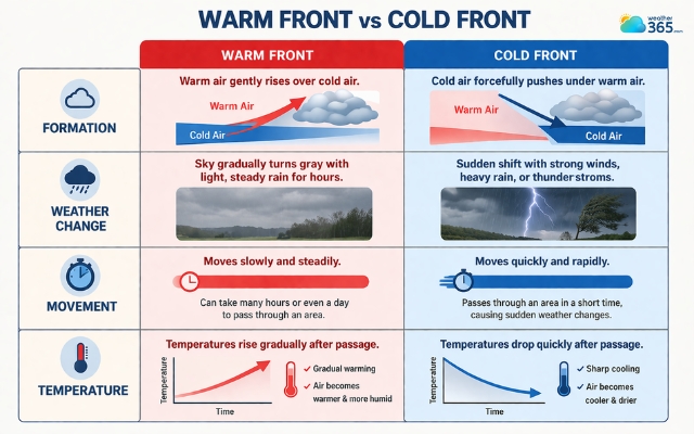
A warm front and a cold front behave very differently, and that difference is exactly why the weather they bring feels so distinct.
Formation
A warm front forms when warm air gently rises over colder air, creating a slow and steady transition.
In contrast, a cold front happens when a mass of cold air pushes underneath warm air more aggressively, forcing it to rise quickly.
This key difference in movement explains everything that follows.
Weather change
If you’ve ever experienced a day where the sky gradually turns gray and light rain lingers for hours, that’s typical of a warm front.
On the other hand, if the weather suddenly shifts with strong winds, heavy rain, or even thunderstorms, you’re likely dealing with a cold front.
You can explore this in more detail about how cold fronts work here!
Movement
Another major difference lies in how fast these systems move.
Warm fronts tend to move slowly, sometimes taking an entire day (or longer) to pass through an area.
Cold fronts, however, move much faster, which is why their weather changes feel more sudden and intense.
Temperature
Temperature changes also behave differently.
With a warm front, temperatures rise gradually after it passes, often bringing more humid air.
With a cold front, temperatures usually drop quickly, leaving the air cooler and drier behind it.
In short, you can think of a warm front as a slow transition and a cold front as a quick disruption.
Both are important, but they affect your day in very different ways.
Difference between warm front and cold front
Warm Front vs Occluded Front
While both warm fronts and occluded fronts involve warm air rising, the way they form and the weather they create are quite different.
To understand this clearly, it helps to first know how different types of fronts interact.
If you need a quick refresher, check out what is a weather front.
Formation
A warm front is a relatively simple system where warm air gradually moves over a colder air mass.
The process is slow, smooth, and predictable, which is why the weather changes feel steady and prolonged.
An occluded front, on the other hand, is more complex.
It forms when a faster-moving cold front catches up with a warm front and lifts the warm air completely off the ground.
At this point, the warm air is no longer in direct contact with the surface; instead, it sits above two cooler air masses.
Impact
This difference has a big impact on weather conditions.
With a warm front, you typically get a clear sequence of layered clouds and steady precipitation.
With an occluded front, the weather becomes less predictable.
You might experience a mix of cloud types, shifting wind patterns, and varying precipitation intensity.
Stage
Another key distinction is the stage of the weather system.
Warm fronts are usually part of the developing phase of a low-pressure system, while occluded fronts tend to appear later, when the system is more mature and complex.
In simple terms, a warm front is organized and gradual, while an occluded front is layered and mixed, often combining features of both warm and cold fronts.
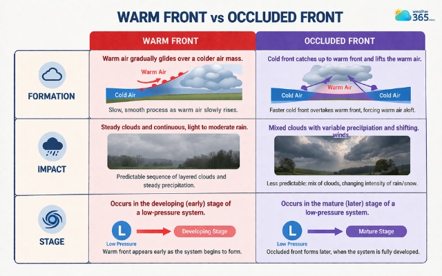
Difference between warm front and occluded front
Conclusion
What is a warm front? If you’ve experienced those long, overcast days where the sun never quite comes back out, a warm front is what’s going on. Learning its signs, like layered clouds and steady drizzle, can help you better plan your day and avoid surprises.
Frequently Asked Questions (FAQs)
Related post

Difference Between High and Low Pressure Systems: Easy Explanation

What Is Cold Front? Understanding Sudden Weather Changes

0 Comment
Leave a comment
Your email address will not be published. Required fields are marked *