Difference Between High and Low Pressure Systems: Easy Explanation
What exactly is the difference between high and low pressure systems, and why does it matter for your daily weather? If you’ve ever wondered why some days are clear while others bring sudden storms, you’re not alone. Let’s break the difference down in the simplest way!
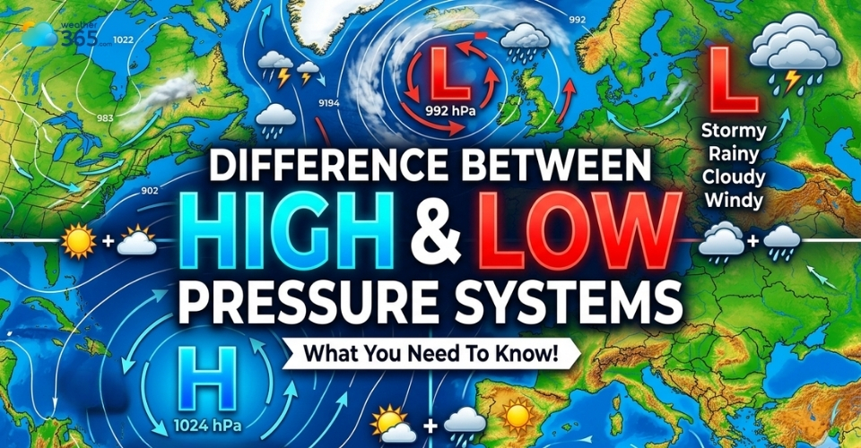
Difference between high and low-pressure systems
- Understanding the air pressure
- What is a high-pressure system?
- Type of weather is associated with high-pressure systems
- Common high-pressure centers
- What is a low-pressure system?
- Type of weather is associated with low-pressure systems
- Common low-pressure centers
- Difference between high and low pressure systems
- Air Movement
- Pressure Level
- Weather
- Wind Flow
- Cloud Formation
- When high and low-pressure systems interact
- Omega High (Omega Block)
- Rex Blocks
Understanding the air pressure
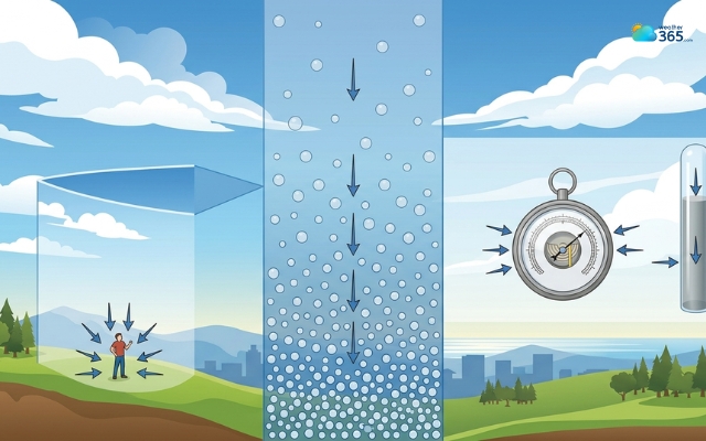
Simply put, air pressure is the force created by the weight of air pressing down on the Earth’s surface.
Even though we don’t feel it, the air around us is constantly pushing in all directions.
This pressure is not fixed; it changes all the time depending on temperature, altitude, and how air moves in the atmosphere.
Air pressure is the force pressing down on the Earth’s surface
A helpful way to picture this is to imagine the atmosphere as a thick blanket of air surrounding the planet.
At lower altitudes (like sea level), there’s more air stacked above you, so the pressure is higher.
As you go higher, like up a mountain, there’s less air above, so the pressure drops. That’s why your ears sometimes “pop” when you travel to higher elevations.
Temperature also plays a big role.
When air gets warm, its molecules spread out, making it lighter. This lighter air rises upward, which reduces the pressure near the ground.
On the other hand, cold air becomes denser and heavier, so it sinks and increases pressure at the surface. This constant cycle of rising and sinking air is what drives changes in pressure.
So, temperature can significantly affect air pressure, but what about vice versa? Can air pressure affect the temperature? Uncover what is air pressure here!
What is a high-pressure system?
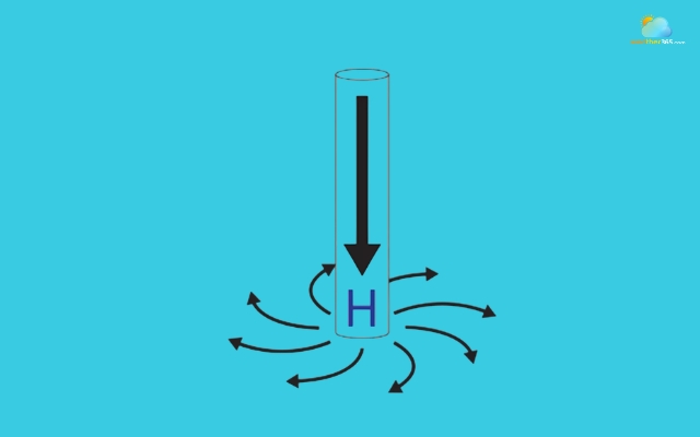
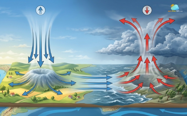
A high-pressure system is an area where the air pressure at the surface is higher than in the surrounding regions.
In simple terms, it means there is more air “stacked” above a location, pressing down with greater force.
More air is “stacked” above a location
But the key idea is that high-pressure is the movement of air.
In a high-pressure system, air from higher in the atmosphere slowly sinks toward the ground. Meteorologists call this process subsidence.
As this air sinks, it becomes more compressed, which increases the pressure near the surface.
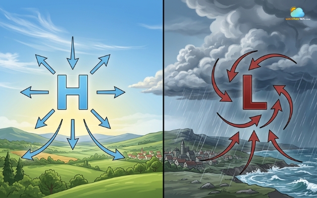
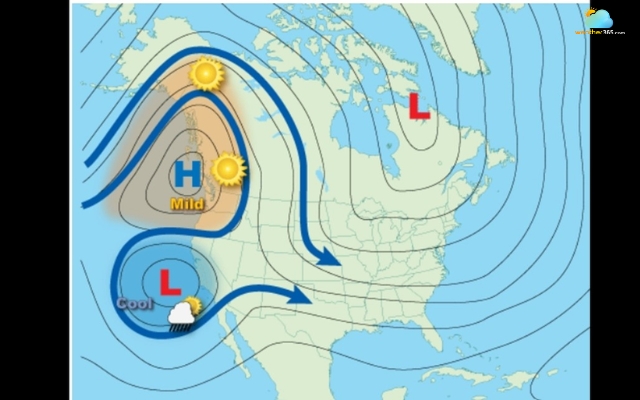
You’ll often see a big “H” on weather maps marking these areas. They are sometimes called anticyclones, and they tend to dominate large regions for days at a time.
Type of weather is associated with high-pressure systems
Because the air is sinking, it actually prevents clouds from forming. Why? Cloud formation needs rising air that cools and condenses.
In a high-pressure system, the opposite is happening: air is moving downward, warming up, and drying out.
That’s why high pressure is usually linked to:
-
Clear skies and lots of sunshine
-
Dry air with low chances of rain
-
Calm or light winds
-
Stable, predictable weather
Think of those bright, cloudless days when everything feels still - that’s classic high-pressure weather.
However, “good weather” doesn’t always mean perfect.
When high pressure sticks around too long, it can lead to heatwaves in summer or trap pollution and fog near the ground in cities.
The same stability that keeps storms away can also keep unwanted air in place.
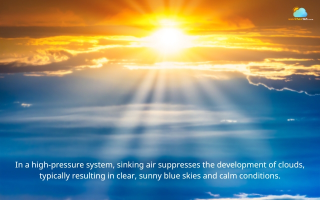
High-pressure conditions lead to a clear sky
Common high-pressure centers
High-pressure systems tend to form in certain regions and follow global patterns.
One of the most well-known examples is the subtropical high-pressure belt, which sits roughly around 30° latitude in both hemispheres.
These systems are responsible for many of the world’s deserts because they consistently bring dry, sinking air.
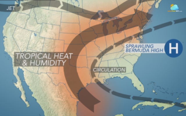
Subtropical high-pressure belt
You might also hear about specific high-pressure centers like:
-
The Bermuda High in the Atlantic, which often influences summer weather
-
Continental high-pressure systems that form over land during winter, bringing cold and dry conditions
Another interesting role of high-pressure systems is that they can act like a “block” in the atmosphere.
They can slow down or even redirect storms, forcing bad weather to move around them instead of through them.
What is a low-pressure system?
A low-pressure system is an area where the atmospheric pressure is lower than that of the surrounding regions.

Atmospheric pressure is lower than that of the surrounding regions
In these systems, air near the surface moves inward and then rises upward into the atmosphere.
As this air rises, it expands and cools because pressure decreases with height.
You can think of a low-pressure system like a “vacuum effect” in the atmosphere.
Air is constantly being pulled in and lifted up.
On weather maps, these systems are marked with a big “L” and are often called cyclones or depressions.
Type of weather is associated with low-pressure systems
If high pressure is linked to calm, clear days, then low pressure is where things get more active, and sometimes messy.
Because the air is rising, it cools down as it goes higher.
Cooler air can’t hold as much moisture, so the water vapor inside it condenses into tiny droplets.
That’s how clouds form. And when enough moisture builds up, it falls as rain or snow.
This is why low-pressure systems are typically associated with:
-
Cloudy or overcast skies
-
Rain, snow, or other forms of precipitation
-
Stronger winds due to air rushing inward
-
Unstable and changing weather conditions
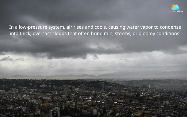
Water vapor condenses into tiny droplets and forms clouds
In reality, most of the “interesting” weather you experience - storms, heavy rain, even thunderstorms comes from low-pressure systems.
The deeper the pressure drops, the more intense the weather can become.
That’s also why weather forecasts pay so much attention to them.
When a low-pressure system is approaching, it’s often a sign that conditions are about to change.
Common low-pressure centers
Low-pressure systems appear in many forms, ranging from everyday rainmakers to large-scale storms that can disrupt entire regions.
Some of the most common examples include
-
Tropical cyclones (like hurricanes or typhoons), which form over warm oceans
-
Mid-latitude cyclones are responsible for everyday rain and seasonal storms
-
Nor’easters, powerful winter storms in North America
If you’ve never heard of this type of storm, you can get a clearer picture through this detailed guide on what a nor’easter is: What is a Nor’easter?
What makes things more interesting is that not all low-pressure storms behave the same way.
For example, nor’easters are often confused with hurricanes, even though they form differently and occur in different conditions.
If you’re curious about how they compare, find out the key differences here!
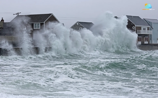
A Nor'easter results from low-pressure condition
Difference between high and low pressure systems
Key differences between high and low pressure lie in how air moves, how clouds form, and ultimately how weather behaves around you.
Air Movement
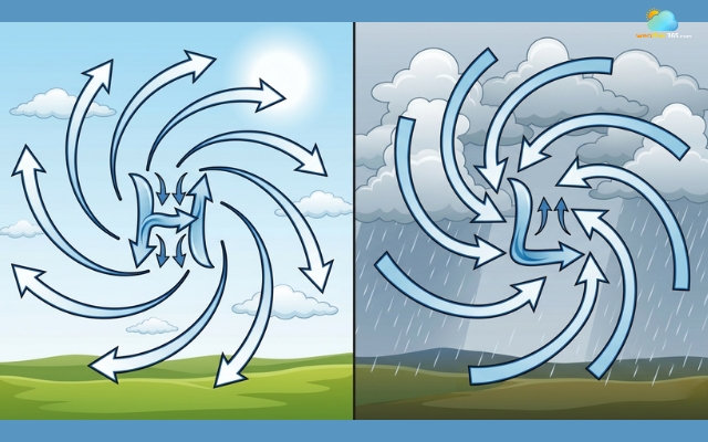
The core difference starts with how air moves in the atmosphere. In a high-pressure system, air slowly sinks from higher altitudes down toward the surface.
This downward movement creates a stable environment where the air isn’t rising or mixing much.
In contrast, a low-pressure system works oppositely.
Air near the ground rises upward into the atmosphere, creating a constant upward flow.
As air rises, it leaves behind a slight “gap” near the surface, which pulls in more air from surrounding areas.
This continuous cycle makes low-pressure systems much more active and dynamic.
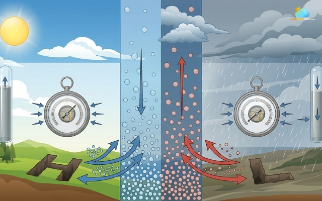
Air movement in high and low-pressure systems
Pressure Level
The pressure itself also behaves differently between the two systems.
In a high-pressure area, the pressure at the surface is higher than in nearby regions because sinking air adds more weight pressing downward.
Meanwhile, a low-pressure system has less force pressing on the surface. Since air is rising and spreading out above, the overall pressure in that area drops compared to its surroundings.
This difference in pressure is what drives air to move from high to low, setting winds in motion.
The difference in pressure drives air to move from high to low
Weather
If you’ve ever wondered why the weather feels so different from one day to another, this is where the answer becomes clear.
High-pressure systems are usually linked to calm, steady weather. The sinking air limits cloud formation, so skies tend to stay clear, and conditions remain dry.
These are the days when the weather feels predictable and doesn’t change much.
Low-pressure systems, on the other hand, are responsible for most of the “active” weather.
Because air is rising, clouds can easily form and grow. This often leads to rain, snow, or even storms.
The weather tends to feel more unsettled, and changes can happen more quickly.
Weather difference between high and low pressure systems
Wind Flow
Wind patterns also reveal a clear contrast between the two systems.
In high-pressure areas, air flows outward from the center.
This outward movement is generally gentle, which is why winds are often light under high pressure.
In low-pressure systems, air flows inward toward the center before rising.
This inward movement can create stronger winds, especially when the pressure difference between regions is large.
That’s why windy conditions are often linked to approaching low-pressure systems.
Wind flows differently in high and low-pressure conditions
Cloud Formation
One of the easiest ways to visually spot the difference is by looking at the sky.
In a high-pressure system, cloud formation is limited. The sinking air warms up slightly, which makes it harder for moisture to condense into clouds.
As a result, skies are often clear or only lightly clouded.
In a low-pressure system, the opposite happens. Rising air cools as it moves upward, allowing moisture to condense and form clouds.
Over time, these clouds can thicken and lead to precipitation, which is why gray skies and rain are so common in low-pressure conditions.
|
Feature |
High-pressure system |
Low-pressure system |
|
Air movement |
Sinking (descending) air |
Rising (ascending) air |
|
Pressure level |
Higher than the surrounding areas |
Lower than the surrounding areas |
|
Weather |
Clear, dry, stable |
Cloudy, wet, unstable |
|
Wind flow |
Outward (diverging) |
Inward (converging) |
|
Cloud formation |
Suppressed |
Enhanced |
When high and low-pressure systems interact
Most of the time, high and low pressure systems move across the map in a steady flow.
But sometimes, they interact in a way that disrupts this movement, and that’s when weather becomes unusually persistent or even extreme.
Meteorologists call these situations blocking patterns. Instead of moving along as usual, pressure systems get “stuck” in place, slowing down or completely stopping the normal west-to-east flow of weather.
This is why you might experience several days of the same weather, whether it’s nonstop sunshine or continuous rain.
Omega High (Omega Block)
An omega block forms when a high-pressure system sits between two low-pressure systems, creating a pattern that looks like the Greek letter Ω on weather maps.
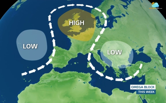
An Omega block on a weather map
What makes this pattern interesting is how stable it is.
The high-pressure system in the middle acts like a barrier, forcing the surrounding weather systems to move around it instead of through it.
As a result, everything slows down.
In real life, this creates a sharp contrast in weather across regions. Areas under the high-pressure center tend to experience dry, warm, and calm conditions.
Meanwhile, the regions under the low-pressure systems on either side may deal with days of clouds, rain, or even storms.
Because omega blocks can last for several days, or even longer, they often lead to prolonged weather events, such as heatwaves in one area and flooding in another.
Rex Blocks
A Rex block is another type of blocking pattern, but its structure is a bit different.
Instead of being side-by-side, a high-pressure system sits directly above a low-pressure system.
This setup creates a kind of atmospheric “gridlock.” The high-pressure system on top prevents the low-pressure system below from moving along its usual path.
As a result, both systems remain stuck in place for an extended period.
The impact on the weather can feel unusual or even “upside-down.”
Areas under the high pressure may experience extended dry and warm conditions, while areas under the low pressure can see persistent clouds, rain, and cooler temperatures.
A Rex block is a type of blocking pattern
Like omega blocks, Rex blocks can last for days and sometimes even longer, depending on how strong the systems are.
The longer they stay in place, the more noticeable their effects become, whether that’s a stretch of perfect blue skies or several days of gloomy, wet weather.
Conclusion
Understanding the difference between high and low pressure systems can change how you look at the weather. Instead of guessing, you’ll know why skies stay clear or suddenly turn stormy, and that makes everyday forecasts much easier to follow.
Frequently Asked Questions (FAQs)
Related post

What Is Barometric Pressure? Simple Explanation for Beginners

0 Comment
Leave a comment
Your email address will not be published. Required fields are marked *