Wind Speed And Direction Explained: What Are They And How Are They Measured?
Wind speed and direction might sound like technical weather terms, but they actually explain a lot about the breeze you feel outside every day. How fast is the wind blowing? Where is it coming from? Understanding these basics helps you read weather forecasts and see how the atmosphere really moves. Let’s discover!
- What Are Wind Speed and Direction?
- What is Wind Speed?
- What is Wind Direction?
- Why Wind Speed and Direction Matter?
- How Wind Speed and Direction Are Measured?
- How Is Wind Speed Measured?
- How Is Wind Direction Measured?
- What Are Wind Speed And Direction Units?
- Common Wind Speed Units
- Compass System for Wind Direction
- How To Read Wind Speed and Direction?
- How To Read Wind Direction?
- How To Read Wind Speed?
What Are Wind Speed and Direction?
When you watch a weather forecast, you often see information about wind speed and direction.
These two measurements describe how air moves in the atmosphere and help meteorologists understand weather patterns.
Simply put, wind speed tells us how fast the air is moving, while wind direction explains where that moving air is coming from.
Together, they provide a clearer picture of how weather systems develop and travel across the planet.
What is Wind Speed?
Wind speed refers to how quickly air moves horizontally across the Earth’s surface.
It describes the rate at which air travels from an area of higher pressure to an area of lower pressure.
Wind speed measure of how quickly the air is moving past a certain point
Wind forms because the Sun heats different parts of the Earth unevenly.
When warm air rises, cooler air moves in to replace it, creating airflow. The strength of this movement determines the wind speed.
Meteorologists usually measure wind speed using instruments called anemometers, which track how fast air is moving. The faster the air flows, the higher the wind speed reading.
Wind speed can vary widely depending on weather conditions:
-
Light breeze: Leaves gently move, and you may barely feel the wind.
-
Moderate wind: Tree branches sway, and you clearly feel the air movement.
-
Strong wind: Difficult walking conditions and potential storm activity.
Because wind speed reflects the strength of atmospheric motion, it plays a key role in predicting storms, cold fronts, and other weather events.
What is Wind Direction?
While wind speed explains how fast the wind moves, wind direction describes the direction the wind originates from.
Wind direction describes the direction the wind originates from
In meteorology, winds are named after the direction they come from, not the direction they travel toward. This detail often confuses beginners.
For example:
-
A north wind means the air is moving from the north down toward the south.
-
An east wind refers to air flowing from the east in the direction of the west.
Why Wind Speed and Direction Matter?
At first glance, wind might seem like a simple part of the weather.
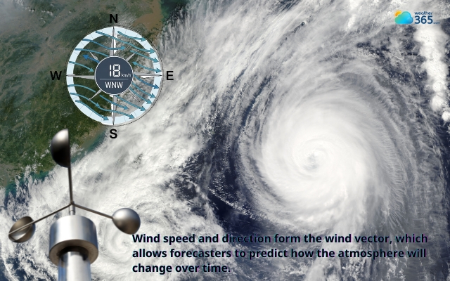
However, current wind direction and speed provide critical information about how the atmosphere behaves.
Weather forecasting
Meteorologists analyze wind patterns to predict how storms, rain systems, and temperature changes will move.
For example, strong winds from the ocean may bring moist air that leads to rainfall, while winds from colder regions can quickly lower temperatures.
Meteorologists analyze wind patterns to predict weather phenomena
Aviation
Pilots carefully monitor wind speed and direction, especially during takeoff and landing.
Strong crosswinds or sudden wind shifts can affect aircraft stability and require adjustments in flight paths.
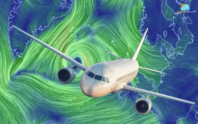
The wind significantly affects the plane's route
Daily life
Wind conditions also affect many everyday activities, such as:
-
sailing and boating
-
flying drones or kites
-
outdoor sports and events
-
construction work and safety planning
Wind even influences how air pollution spreads in cities and how quickly smoke or dust travels during environmental events.
Because of these impacts, measuring and understanding wind speed and direction is essential for both scientific research and practical decision-making in daily life.
How Wind Speed and Direction Are Measured?
Meteorologists rely on specialized instruments to measure wind speed and direction accurately.
These measurements are usually collected at weather stations, airports, ships, and research sites.
Sensors are typically installed on towers or masts in open areas so buildings or trees do not block the airflow.
How Is Wind Speed Measured?
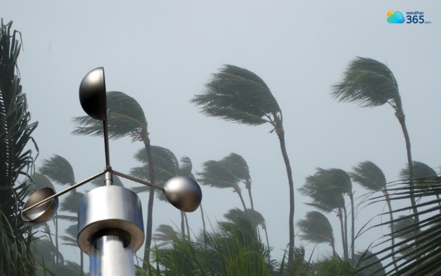
Wind speed is most commonly measured using an instrument called an anemometer.
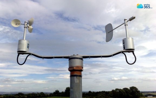
An anemometer is the most popular tools in measuring wind speed
The classic design is the cup anemometer, which consists of three or four small cups attached to horizontal arms that rotate around a vertical axis.
When wind pushes against the cups, they begin to rotate. Stronger wind makes the cups spin more quickly.
Sensors then count the number of rotations over a specific time period to calculate wind speed.
This simple mechanism is widely used because it is reliable and relatively easy to maintain.
The rotation rate is directly related to the speed of the airflow, allowing weather stations to convert the spinning motion into wind speed data.
Other instruments can also measure wind speed, including:
-
Propeller or vane anemometers – use a rotating propeller to detect airflow
-
Sonic (ultrasonic) anemometers – measure wind by analyzing how sound waves travel through moving air
-
Wind profilers – radar-based systems that measure wind speed at different heights in the atmosphere
If you want a deeper explanation of the process, you can explore our detailed guide on how to measure wind speed.
How Is Wind Direction Measured?
Wind direction is usually measured using a wind vane, also called a weather vane.
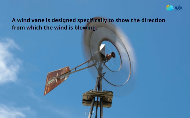
A wind vane is one of the oldest meteorological instruments
A wind vane consists of a horizontal arm mounted on a vertical spindle so it can rotate freely.
One end of the arm has a larger surface area that catches the wind, while the other end acts as a pointer.
When the wind blows, the larger end is pushed away, and the pointer aligns with the direction the wind is coming from.
In addition to wind vanes, meteorologists may use several other tools to determine wind direction:
-
Sonic anemometers – calculate wind direction using ultrasonic signals between sensors
-
Wind socks – commonly used at airports to visually show wind direction and approximate strength
-
Wind alarms – trigger warnings when wind reaches dangerous levels
-
Wind profilers – measure wind direction and speed at different atmospheric layers
What Are Wind Speed And Direction Units?
Once meteorologists measure wind speed and direction, the data must be expressed in standardized units so it can be understood and compared worldwide.
Different industries may prefer different units, but they all describe the same two things: how fast the wind moves and where it comes from.
Let’s look at the most common systems used today.
Common Wind Speed Units
Wind speed can be reported using several units depending on the field or country. Even though the numbers may look different, they all represent the same physical movement of air.
Here are the most widely used wind speed units:
Knots (kn)
Knots are commonly used in aviation and maritime navigation.
One knot equals one nautical mile per hour, which is about 1.85 kilometers per hour.
Because navigation historically relied on nautical miles, pilots and sailors still use knots as the standard unit today.
Meters per second (m/s)
Meters per second is the standard scientific unit used in meteorology and atmospheric research.
Many weather stations and research institutions prefer this unit because it fits naturally with the International System of Units (SI).
Kilometers per hour (km/h)
This is one of the most familiar units for the general public.
Weather forecasts in many countries report wind speed in kilometers per hour, making it easy to compare with vehicle speeds or other everyday measurements.
Miles per hour (mph)
Miles per hour is commonly used in the United States and the United Kingdom.
Similar to km/h, this unit is easy for people to understand because it is also used for road speed limits.
Beaufort Scale
In addition to numerical units, wind strength can also be described using the Beaufort scale.
This scale ranges from 0 (calm) to 12 (hurricane force) and links wind speed to visible effects in nature.
Learn details about the Beaufort Scale here!

There are a variety of wind speed units
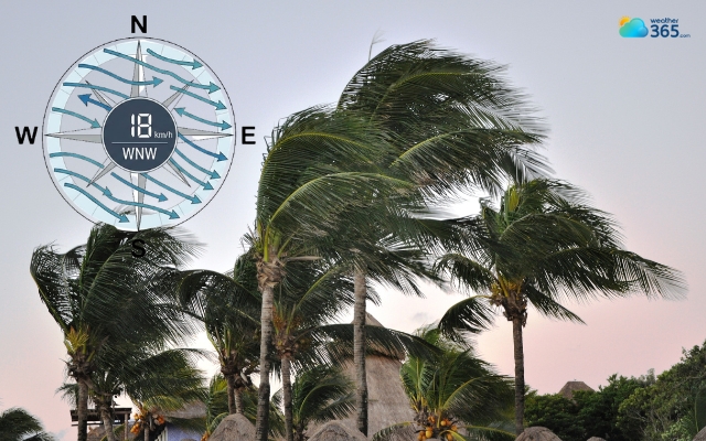
Compass System for Wind Direction
While wind speed uses numerical units, wind direction is usually expressed using compass directions or degrees.
These systems help describe exactly where the wind is coming from.
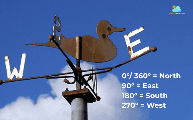
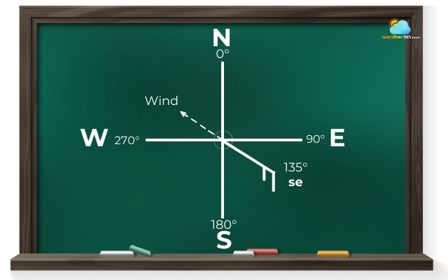
360-degree system
Meteorologists often use a 360-degree compass system for precise measurements. In this system, the full circle of directions is divided into degrees.
The main reference points are:
-
0° or 360° = North
-
90° = East
-
180° = South
-
270° = West
For example, if the wind direction is 135°, it means the wind is coming from the southeast.
This system is especially useful for scientific observations, weather models, and aviation because it allows for very accurate direction measurements.
Cardinal and intercardinal directions
For everyday forecasts, wind direction is often simplified using compass directions.
The four main cardinal directions are:
-
N (North)
-
E (East)
-
S (South)
-
W (West)
Between these are the intercardinal directions, which provide more detail:
-
NE (Northeast)
-
SE (Southeast)
-
SW (Southwest)
-
NW (Northwest)
Some weather systems go even further and divide directions into 16 compass points, such as NNE or WSW, for even greater accuracy.
Wind direction is usually expressed using compass directions
How To Read Wind Speed and Direction?
Seeing wind speed and direction on a weather map can feel confusing at first. You might notice small symbols, arrows, or numbers that seem technical.
However, once you understand how they work, reading wind data becomes much easier.
Meteorologists often display wind information using visual symbols, charts, or diagrams.
One of the most common tools is the wind barb, a symbol used on weather maps that shows both wind direction and wind speed at the same time.
A wind barb usually looks like a straight line with small “feathers” or flags attached.
The direction of the line shows where the wind is coming from, while the feathers represent the wind speed.
How To Read Wind Direction?
To understand wind direction on a weather map, start by looking at the orientation of the wind barb or arrow.
The rule is simple:
The line points toward the direction the wind is coming from.
For example:
-
If the line points north, the wind comes from the north.
-
If the line points southwest, the wind originates from the southwest.
This method follows the same principle used in meteorology, where winds are named after their source direction.
Weather apps and forecast charts may also show wind direction using arrows instead of barbs.
The arrow usually points in the direction the wind is moving, while the label indicates where it originates.
If you want a more detailed explanation and examples, you can read our full guide on how to read wind direction.
Look at the orientation of the wind barb to check the wind direction
How To Read Wind Speed?
Wind speed on weather maps is usually represented through symbols, numbers, or visual charts.
When looking at wind barbs, the speed is shown by the small lines attached to the main stem:
-
Short line (half barb) = 5 knots
-
Long line (full barb) = 10 knots
-
Triangle flag = 50 knots
Meteorologists add these symbols together to represent the total wind speed. For example, a wind barb with one long line and one short line represents 15 knots of wind.
Another helpful visualization tool is the wind rose.
Instead of showing wind at a single moment, a wind rose displays how often the wind blows from different directions over time, along with typical speed ranges.
If you want to learn how to interpret these diagrams, check out our guide on how to read wind rose!
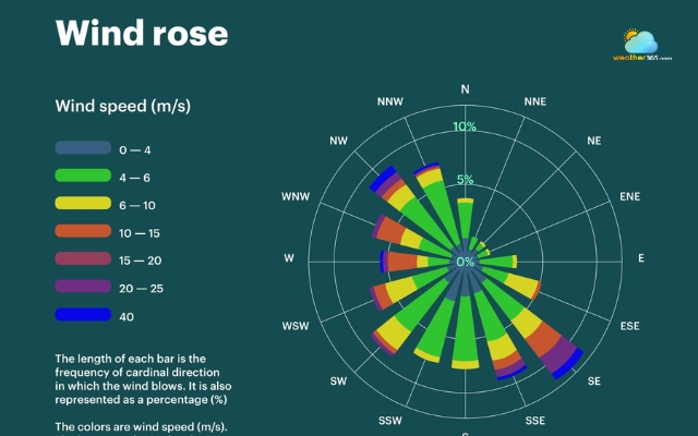
The wind rose is a visualization tool to read wind speed
Final Thought
Wind speed and direction reveal a lot about how the atmosphere behaves. Once you understand what they mean and how to read them, weather forecasts suddenly make much more sense. With a little practice, you will start spotting wind patterns like a mini meteorologist.
Frequently Asked Questions (FAQs)
Related post

Beaufort Wind Scale Chart: Discover Wind Speed Levels and How To Read Them

How To Measure Wind Speed: Step-by-Step Guide for Accurate Measurement

0 Comment
Leave a comment
Your email address will not be published. Required fields are marked *