Beaufort Wind Scale Chart: Discover Wind Speed Levels and How To Read Them
Have you ever looked outside and wondered how strong the wind really is? Meteorologists often use the Beaufort wind scale chart to estimate wind speed based on visible effects like moving leaves, waves, or swaying trees. In this guide, you will learn what the Beaufort scale is, where it came from, and how to read the chart to quickly estimate wind strength.
Discover the Beaufort wind scale chart
- What is The Beaufort Wind Scale?
- Origin of the Beaufort Scale
- What Is the Beaufort Scale Used For?
- Beaufort Wind Scale Chart
- Beaufort Scale 0–3: Light Wind
- Beaufort Scale 4–7: Moderate to Strong Wind
- Beaufort Scale 8–12: High Wind to Hurricane Force
- How To Read The Beaufort Wind Scale Chart?
- Look at the Beaufort Number
- Check the Wind Speed Range
- Observe the Effects on Land and Sea
- Combine Observation With the Chart
What is The Beaufort Wind Scale?
The Beaufort Wind Scale is a system used to estimate wind speed by observing its effects on land and sea.
Instead of relying only on instruments, the scale links wind speed to visible changes such as ripples on water, moving branches, or strong waves.
The Beaufort wind scale chart is a system for estimating wind speed
The scale ranges from 0 to 12, with:
-
0 represents calm air
-
12 represents hurricane-force wind
Because it is simple and practical, the Beaufort scale is still widely used in meteorology, marine navigation, and weather education.
Origin of the Beaufort Scale
The Beaufort scale was developed in 1805 by Sir Francis Beaufort, an officer in the British Royal Navy.
At that time, sailors needed a reliable way to describe wind strength while at sea. Beaufort created a system that connected wind conditions to how sails behaved on ships.
Over time, the scale was adapted for modern weather observation and linked to specific wind speed ranges measured in km/h or mph.
The Beaufort wind scale chart was named after Sir Francis Beaufort
What Is the Beaufort Scale Used For?
Although the technology can measure wind speed very precisely, the Beaufort scale is still widely used because it helps people quickly understand wind conditions in real life.
One of its main uses is in weather observation and forecasting.
Meteorologists often refer to Beaufort levels when describing wind intensity, especially in educational materials or simplified forecasts.
The scale is also important in marine navigation. Sailors, fishermen, and shipping crews frequently use Beaufort levels to estimate sea conditions.
Since stronger winds usually create larger waves, the scale helps mariners judge whether conditions are safe for travel.
Another common use is in outdoor activities.
People involved in sailing, surfing, aviation, drone flying, or hiking often rely on the Beaufort scale to understand how wind may affect their activities.
For instance, a gentle breeze may be perfect for sailing, but strong winds could make drone flights unstable.
Finally, the scale is widely used in weather education because it helps beginners connect scientific measurements with real-world observations.
Instead of memorizing numbers, learners can simply observe what the wind is doing around them.

The Beaufort wind scale is used for multiple purposes
Beaufort Wind Scale Chart
The Beaufort wind scale organized the wind strength into 13 levels, from 0 to 12, making it easier to understand how strong the wind is in real-world conditions.
Each level corresponds to a specific wind speed range and includes a description of what the wind looks like on land or at sea.
Instead of only using numbers, the chart connects wind speed to visible effects in nature.
For example, you might see leaves rustling, small trees swaying, or waves forming on the ocean.
These observations help people estimate wind strength even without weather instruments.
Meteorologists, sailors, and outdoor enthusiasts often use the Beaufort chart because it provides a quick visual guide to wind conditions.
Beaufort Scale 0–3: Light Wind
The first part of a Beaufort wind scale chart describes the very light wind conditions, which are common during calm and stable weather.
These winds are usually gentle and rarely cause any problems.
Beaufort 0 - Calm
At this level, the air is completely still. Smoke rises straight upward, and there is no noticeable movement of leaves or branches.
The wind speed is extremely low, typically below 1 km/h.
Beaufort 1 - Light Air
A faint breeze may be noticeable, but it has very little impact on the environment. Wind speeds generally range from 1 to 5 km/h.
Smoke may drift slightly, but weather vanes usually remain still.
Beaufort 2 - Light Breeze
At this stage, the wind becomes slightly more noticeable. Wind speeds usually reach 6 to 11 km/h.
You might see leaves rustling or feel a gentle breeze on your face. Small ripples may begin forming on water surfaces.
Beaufort 3 - Gentle Breeze
This level marks the upper end of light winds. Wind speeds typically range from 12 to 19 km/h
Leaves and small twigs move continuously, and flags may start to extend slightly.
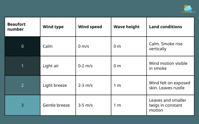
Beaufort wind scale chart from 0 to 3
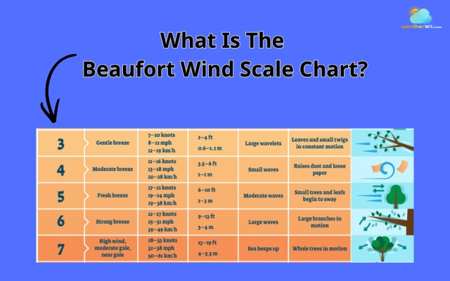
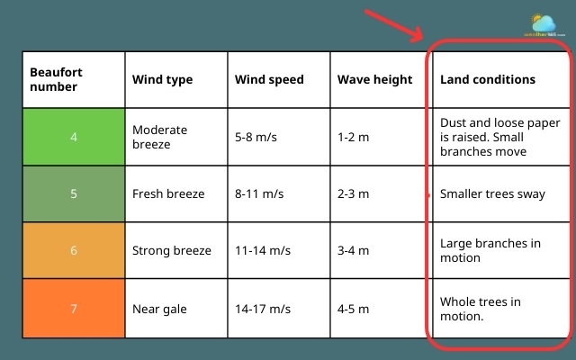
Beaufort Scale 4–7: Moderate to Strong Wind
The middle section of the Beaufort wind scale chart represents winds that are strong enough to noticeably affect the environment.
At these levels, wind becomes more powerful and can start influencing daily activities.
Beaufort 4 – Moderate Breeze
Loose paper and small debris may begin to move across the ground.
Dust can be lifted into the air, and small branches may sway. Wind speeds typically range from 20 to 28 km/h.
Beaufort 5 – Fresh Breeze
At this level, the wind becomes quite noticeable.
Small trees begin to sway, and waves on lakes or coastal waters become more visible. Wind speeds usually reach 29 to 38 km/h.
Beaufort 6 – Strong Breeze
Large branches start moving, and using an umbrella can become difficult.
In coastal areas, waves grow larger with visible white crests. Wind speeds generally range from 39 to 49 km/h.
Beaufort 7 – Near Gale
This is where wind conditions begin approaching storm strength. Whole trees may sway, and walking against the wind becomes harder.
At sea, waves become higher and more powerful. Wind speeds typically reach 50 to 61 km/h.
These wind levels can start affecting transportation, outdoor work, and marine conditions, especially in exposed areas.
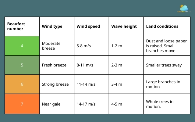
Beaufort wind scale chart from 4 to 7
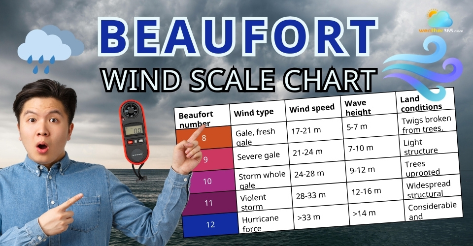
Beaufort Scale 8–12: High Wind to Hurricane Force
The highest section of the Beaufort wind scale chart describes very strong and potentially dangerous winds.
These levels are usually associated with severe storms or powerful weather systems.
Beaufort 8 – Gale
Twigs may break off trees, and progress against the wind becomes difficult.
At sea, waves grow significantly higher. Wind speeds usually range from 62 to 74 km/h.
Beaufort 9 – Strong Gale
Branches may break from trees, and minor structural damage can occur.
Roof tiles or small structures may begin to loosen. Wind speeds typically reach 75 to 88 km/h.
Beaufort 10 – Storm
At this stage, the wind becomes very destructive.
Trees may be uprooted, and structural damage becomes more likely. Wind speeds range from 89 to 102 km/h.
Beaufort 11 – Violent Storm
Severe damage can occur, especially to buildings and vegetation.
Large waves and dangerous sea conditions develop. Wind speeds usually reach 103 to 117 km/h.
Beaufort 12 – Hurricane Force
This is the highest level on the Beaufort scale.
Winds exceed 118 km/h, capable of causing widespread damage. These conditions are typically associated with hurricanes or powerful tropical storms.
Learn more about high wind alerts here!
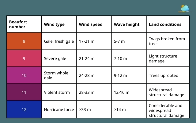
Beaufort wind scale chart from 8 to 12
How To Read The Beaufort Wind Scale Chart?
At first glance, the Beaufort wind scale chart may look like just a list of numbers and wind speeds.
But once you understand how it works, the chart becomes a very practical tool for estimating wind strength in everyday situations.
Unlike many weather measurements that require instruments, the Beaufort scale is designed so that anyone can estimate wind speed by observing what is happening around them.
By paying attention to signs in nature, such as moving leaves, swaying trees, or waves on water, you can quickly identify the approximate Beaufort level.
Look at the Beaufort Number
The first column in the Beaufort wind scale chart is the Beaufort number, which ranges from 0 to 12. This number represents the strength of the wind.
Each level describes a different stage of wind intensity:
-
0–1 indicates calm or barely noticeable wind
-
2–3 represents light breezes
-
4–7 describes moderate to strong winds
-
8–12 indicates very strong or dangerous winds
This numbering system allows meteorologists and sailors to communicate wind conditions quickly.
For example, saying “Beaufort 6” immediately tells someone that the wind is a strong breeze with noticeable environmental effects.
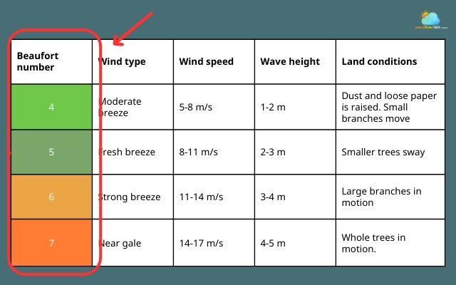
Check the Beaufort number
Check the Wind Speed Range
Next, the chart shows the wind speed associated with each Beaufort level. These speeds are usually listed in units such as:
-
Kilometers per hour (km/h)
-
Miles per hour (mph)
-
Knots, which are commonly used in marine and aviation contexts
For instance, Beaufort 5 (fresh breeze) typically corresponds to wind speeds around 29–38 km/h.
Even though modern weather stations measure wind precisely, the Beaufort chart still serves as a useful reference for translating numbers into real-world conditions.
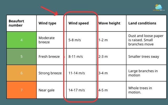
Check the corresponding wind speed
Observe the Effects on Land and Sea
One of the most useful parts of the beaufort wind scale chart is the description of visible effects in the environment.
These observations make the scale easy to use without instruments.
At sea, the chart also describes wave patterns, such as ripples, whitecaps, or large breaking waves.
These signs help sailors estimate wind strength even when instruments are unavailable.
Check the last column to see the effects of the wind
Combine Observation With the Chart
The best way to use the Beaufort wind scale chart is to combine visual observation with the descriptions in the chart.
Start by observing your surroundings: Are leaves barely moving? Are trees swaying strongly? Is dust blowing across the ground?
Next, compare these observations with the descriptions listed for each Beaufort level.
Once you find the closest match, you can estimate the approximate wind speed and wind category.
This simple method is why the Beaufort scale remains useful today. It transforms complex wind measurements into clear visual clues that anyone can recognize.
Final Thought
The Beaufort wind scale chart makes understanding wind much easier by connecting numbers with what you can actually see outdoors. With instruction, the scale helps you quickly estimate wind strength. Once you know how to read it, you will start noticing these wind signs everywhere in everyday weather.
Frequently Asked Questions (FAQs)
Related post

How To Measure Wind Speed: Step-by-Step Guide for Accurate Measurement

Types Of Wind: Understanding Different Wind Classifications

0 Comment
Leave a comment
Your email address will not be published. Required fields are marked *