What Does Wind Chill Mean? Complete Guide to Wind Chill Explained
What does wind chill mean, and why can a cold day suddenly feel much harsher when the wind picks up? Wind chill explains how moving air accelerates heat loss from your body. In this guide, you will learn how it works, how it’s calculated, and why it matters for cold-weather safety. Diving in!
Discover what wind chill means
What Does Wind Chill Mean?
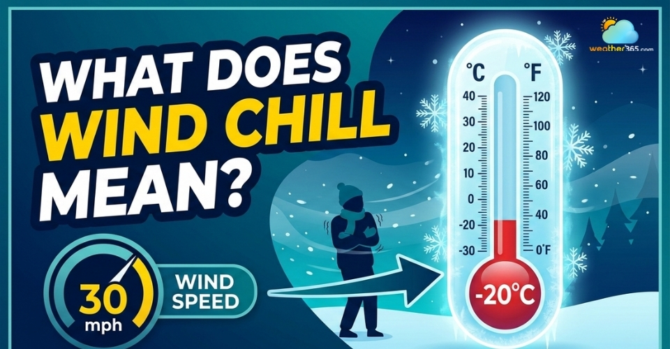
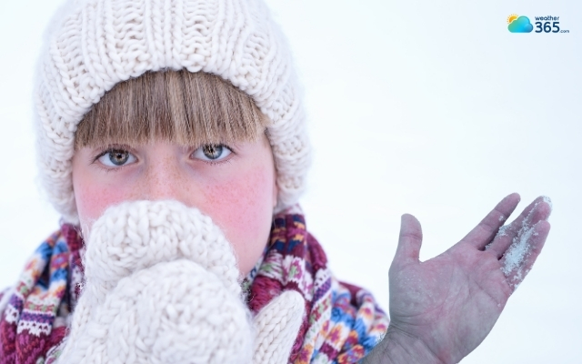
Wind chill is the "feels like" temperature that combines air temperature and wind speed to show how cold it feels on exposed skin.
As wind increases, it removes body heat more quickly, making the air feel colder than the actual temperature.
For example, the air temperature may be 0°C (32°F), but a strong wind can make it feel like −5°C (23°F) or −10°C (14°F).
This lower perceived temperature is called the wind chill temperature.
Wind chill indicates how much colder you feel when the wind is blowing
When was the concept wind chill coined?
The concept of wind chill dates back to 1939, when Antarctic explorer Paul Siple and scientist Charles Passel studied how quickly water froze in different wind conditions.
Their experiments helped scientists understand how wind speeds influence heat loss in extremely cold environments.
Their early research eventually led to the wind chill index, which meteorologists now use to estimate how cold weather conditions feel to people outdoors.

“Wind chill” comes from Antarctic explorer Paul Siple
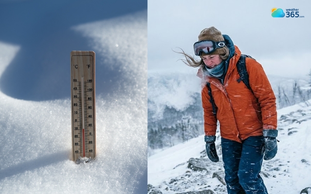
Do you know what’s the difference between wind chill and actual temperature when planning outdoor activities? While the actual temperature tells you what the thermometer reads, the wind chill tells you how your body will actually experience the cold. Understanding this difference is crucial for your safety. When planning outdoor activities, relying only on the actual temperature can be a dangerous mistake - strong winds will strip away your body heat much faster than you expect. |
Key Aspects of Wind Chill
To understand wind chill more clearly, it helps to break it down into a few important ideas:
The “Feels Like” Temperature
Wind chill represents apparent temperature, meaning how cold conditions feel rather than the actual air temperature.
If the wind increases while the temperature stays the same, the wind chill value will drop, making it feel colder.
Heat Loss From the Body
The main purpose of the wind chill index is to estimate how quickly your body loses heat in windy conditions.
Faster heat loss can quickly lower skin temperature and, in extreme cases, even reduce core body temperature.
Safety Indicator
Wind chill is widely used in weather forecasts because it helps people understand the risk of cold-weather injuries such as frostbite or hypothermia. In severe conditions, exposed skin can freeze within minutes.
A Calculated Index
Wind chill is not measured directly with a thermometer.
Instead, meteorologists calculate it using a formula that combines air temperature and wind speed to estimate the cooling effect on exposed skin.

Wind chill index estimates how quickly your body loses heat in windy conditions
How Wind Chill Chart Work?
A wind chill chart works by combining air temperature and wind speed to estimate the temperature your body actually feels.
When the air is calm, your body naturally warms a thin layer of air around your skin. This layer acts like a small buffer that slows down heat loss.
However, when the wind blows, it constantly removes that warmer layer and replaces it with colder air.
As a result, your body must work harder to maintain its normal temperature.
Meteorologists and weather agencies use wind chill charts to quickly estimate how cold outdoor conditions will feel without performing manual calculations.
Now let’s discover the wind chill chart and how to read it!
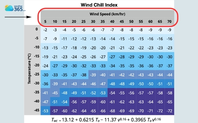
Wind Chill Chart
A typical wind chill chart looks like a grid or table.
The top row shows wind speed, usually measured in miles per hour (mph) or kilometers per hour (km/h).
The left column shows the actual air temperature.
Inside the chart are numbers representing the wind chill temperature, or how cold it feels on exposed skin.
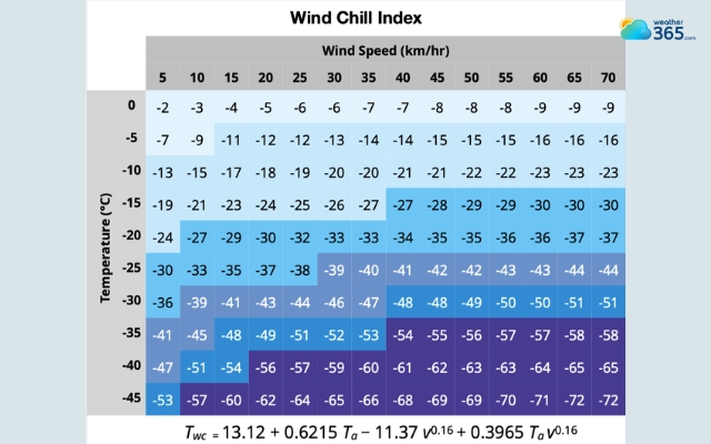
Wind chill chart
How To Read The Wind Chill Chart?
To read the wind chill chart, let’s look at the wind chart again and follow our guide below:
Identify the air temperature
First, find the actual air temperature on the left side of the wind chill chart.
This value is usually listed in degrees Celsius (°C) or Fahrenheit (°F). The chart arranges temperatures in rows from warmer to colder.
For example, if the current temperature is −5 °C, locate −5 °C on the vertical axis of the chart.
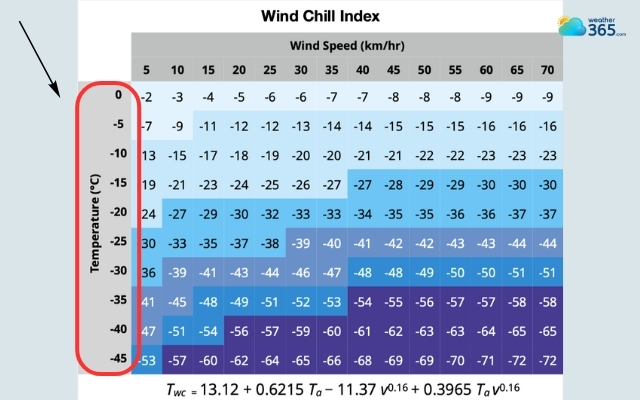
The temperature ranges from -45 to 0 degrees
Find the wind speed
Next, look at the top row of the chart where wind speeds are listed.
These values show how fast the wind is blowing, typically measured in km/h or mph.
For instance, if the wind speed is 30 km/h, locate that value along the top of the chart.
Curious how to measure wind speed? Learn here!
Find the wind speed on the top of the chart
Follow the row and column
Now trace the temperature row horizontally and the wind speed column vertically.
Where these two lines intersect in the chart is the wind chill value.
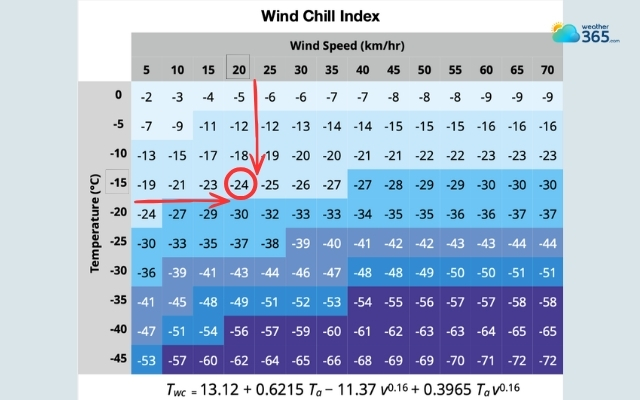
Wind chill value is where the two lines intersect
Read the wind chill temperature
The number at the intersection represents the wind chill temperature, which indicates how cold it feels on exposed skin.
For example:
Air temperature: −5 °C
Wind speed: 30 km/h
On the chart, the intersection may show −13 °C, meaning the wind makes the environment feel as cold as −13 °C in calm air.
How Is Wind Chill Calculated and What Factors Affect It?
Wind chill index is a scientific calculation based on temperature, wind speed, and heat loss from the human body.
Meteorologists use mathematical formulas and physical models to estimate how quickly the body loses heat when exposed to cold, windy conditions.
Instead of measuring wind chill directly with a thermometer, weather agencies calculate it using a standardized formula developed by meteorological researchers.
This formula combines air temperature and wind speed to estimate the apparent temperature, or how cold the environment feels to exposed skin.
The modern wind chill formula used by weather agencies such as the National Weather Service looks like this:
Wind Chill (°F) = 35.74 + 0.6215T − 35.75(V^0.16) + 0.4275T(V^0.16)
Where:
T = Air temperature (°F)
V = Wind speed (mph)
Although the equation may look complicated, the concept behind it is straightforward: the colder the air and the stronger the wind, the lower the wind chill value becomes.
Because the formula is complex, most people don’t calculate wind chill manually. Instead, meteorologists use wind chill charts or weather software that automatically apply this equation.
For example:
Air temperature: 20°F (−6°C)
Wind speed: 15 mph
The calculated wind chill is roughly 6°F (−14°C), meaning your body loses heat at a rate similar to being in 6°F calm air.
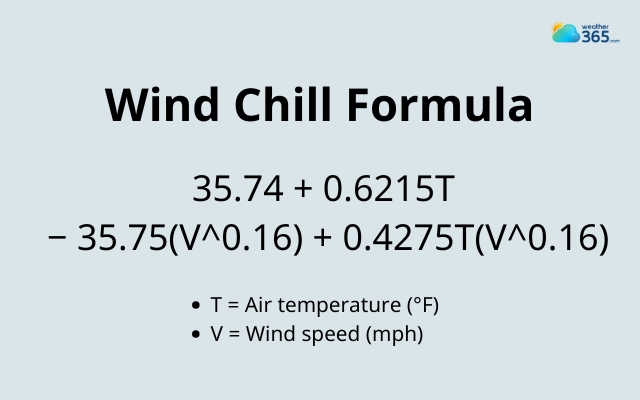
Wind chill formula
Danger Of Wind Chill
When wind combines with low temperatures, it dramatically increases the rate at which your body loses heat.
As heat escapes faster, your skin temperature drops quickly, and your body must work harder to maintain a safe internal temperature.
This accelerated heat loss is why windy winter conditions can become dangerous much faster than calm cold days.
Even if the thermometer does not show extremely low temperatures, strong winds can push the “feels like” temperature into a dangerous range, increasing the risk of cold-related illnesses.
Danger
One of the biggest reasons wind chill is taken seriously is its connection to cold-related medical conditions.
When the body loses heat faster than it can produce it, several dangerous health problems can occur.
Frosbite
Frostbite happens when skin and underlying tissues freeze due to extreme cold.
Wind chill increases the likelihood of frostbite because strong winds remove heat from exposed skin very quickly.
Common areas affected include the fingers, toes, ears, and nose. In severe cases, frostbite can cause permanent tissue damage.
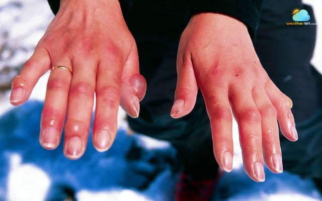
Wind chill increases the likelihood of frostbite
Hypothermia
Another major danger is hypothermia, a condition that occurs when the body’s core temperature drops below about 35°C (95°F). This happens when the body loses heat faster than it can generate it.
Symptoms may include intense shivering, confusion, fatigue, and slowed breathing.
Hypothermia can become life-threatening if a person remains exposed to cold and wind for too long without proper clothing or shelter.
Hypothermia is when the body’s core temperature drops below about 35°C
Cardiovascular Strain
Extreme cold and wind can also put stress on the heart and circulatory system.
In cold weather, blood vessels narrow to conserve heat, which increases blood pressure and makes the heart work harder.
For people with existing heart conditions, this added strain can increase health risks during severe cold events.
Overall, the colder the wind chill value becomes, the faster these dangers can develop.

Extreme cold and wind can cause a heart attack
Who is most at risk
Although wind chill affects everyone outdoors, certain groups are more vulnerable to cold-related health problems. Who are they?
Infants and young children
Children lose body heat faster than adults because they have smaller bodies and less insulation. They may also have difficulty recognizing or communicating symptoms of cold exposure.
Elderly
Elderly individuals often have slower circulation and may have underlying medical conditions that make it harder for the body to regulate temperature.
This increases their risk of hypothermia in cold and windy conditions.
Outdoor Workers
People who work outside, such as construction workers, delivery personnel, or emergency responders, face prolonged exposure to cold winds.
Continuous exposure significantly increases the chance of cold stress and frostbite.
The Homeless
Individuals without reliable shelter are particularly vulnerable because they may be exposed to cold wind for extended periods without proper protection.
Hikers & hunters
People participating in winter activities may underestimate the danger of wind chill, especially in remote areas.
Sudden changes in wind or temperature can quickly create hazardous conditions.

Infants, the elderly, workers, and the homeless are the most vulnerable
Wind Chill Safety Tips
Wind chill can make cold weather much more dangerous than the actual air temperature suggests.
Because wind increases the rate at which your body loses heat, people can develop frostbite or hypothermia much faster in windy conditions.
Taking a few simple precautions can greatly reduce these risks when temperatures drop.
Limit time outdoors
Dress in multiple layers
Cover exposed skin
Stay dry and avoid sweating
Eat warm food and stay hydrated
Prepare for travel in winter conditions

Keep yourself warm to avoid wind chill dangers
Final Thought
In short, understanding what does wind chill mean is only the first step. The most important thing is to prepare properly before going outdoors. Dressing appropriately, covering exposed skin, and limiting exposure time can significantly reduce the health risks associated with cold, windy weather.
Frequently Asked Questions (FAQs)
Related post

How To Measure Wind Speed: Step-by-Step Guide for Accurate Measurement

Types Of Wind: Understanding Different Wind Classifications

0 Comment
Leave a comment
Your email address will not be published. Required fields are marked *