Difference between Latitude and Longitude: Examples and Key Differences
Are you confused about the difference between latitude and longitude? Don’t worry! You’re not alone! Many people still mix them up when reading maps or using GPS. Scrolling down, and this guide breaks it down simply so you can finally understand and use them with confidence.
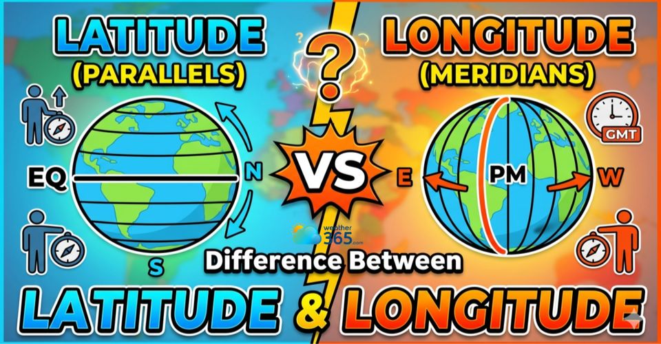
What is the difference between latitude and longitude?
- What is latitude?
- Line Language
- Importance of Latitude
- What is longitude?
- Time Travel
- Importance of Longitude
- Difference between latitude and longitude
- Geographic Orientation and Purpose
- Impact on Navigation and Mapping
- Influence on Time Keeping and Time Zones
- Utilization in GPS Technology
- Key Applications of Latitude and Longitude
- Navigation and Travel
- GPS and Digital mapping systems
- Weather forecasting
- Scientific research & environmental studies
- Global Communication and Logistics
What is latitude?
If you’ve ever looked at a map and wondered how people know exactly how far north or south a place is, the answer lies in latitude.
In simple terms, latitude is a way of measuring distance on Earth based on how far a location is from the Equator.
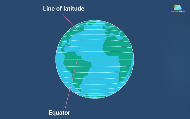
Latitude represents lines running east-west
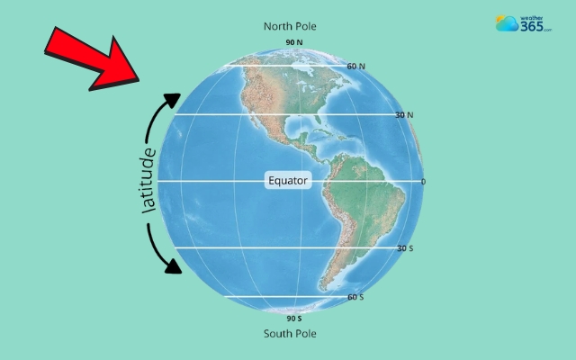
Latitude is expressed in degrees (°), starting at 0° at the Equator - the imaginary line that divides the Earth into the Northern and Southern Hemispheres.
As you move north toward the Arctic, the latitude increases up to 90° North. Similarly, moving south toward Antarctica takes you to 90° South.
This system makes it easy to understand a location’s vertical position on the planet.
Line Language
What makes latitude especially intuitive is how its lines are designed.
These lines, often called parallels, run horizontally from east to west and never cross each other.
No matter where you are on Earth, lines of latitude remain evenly spaced, which helps create a consistent and reliable grid for mapping.
When you see a world map with horizontal lines stretching across continents and oceans, you’re looking at latitude in action.
Major lines of latitude are:
The Equator (0°)
Tropic of Cancer (23.5°)
Tropic of Capricorn (23.5°)
Arctic Circle (66.5°)
Antarctic Circle (66.5°)
North Pole (90°)
South Pole (90°)
Parallels never cross each other
Importance of Latitude
Beyond just positioning, latitude plays a powerful role in shaping the world around us.
Climate
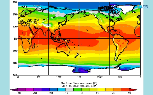
One of its most important functions is influencing the climate.
Areas near the Equator tend to be warmer because they receive more direct sunlight throughout the year.
As you move toward higher latitudes - closer to the poles - the angle of sunlight changes, resulting in cooler temperatures and more seasonal variation.
Is this cooler temperatures related to the polar vortex? Learn here!
This is why tropical regions, temperate zones, and polar areas exist in distinct bands across the Earth.
Navigation
Latitude is also essential in navigation.
Before modern GPS systems, sailors and explorers relied heavily on latitude to determine their position at sea.
By observing the position of the sun during the day or stars at night, they could estimate how far north or south they were.
Even today, latitude remains a core component of global positioning systems, working together with longitude to pinpoint exact locations anywhere on Earth.
Sailors and explorers relied heavily on latitude
What is longitude?
While latitude tells you how far north or south you are, longitude answers the other half of the question: how far east or west is a location?
Longitude determines position horizontally
If you’ve ever used Google Maps and seen coordinates with two numbers, longitude is the one that determines your position across the globe horizontally.
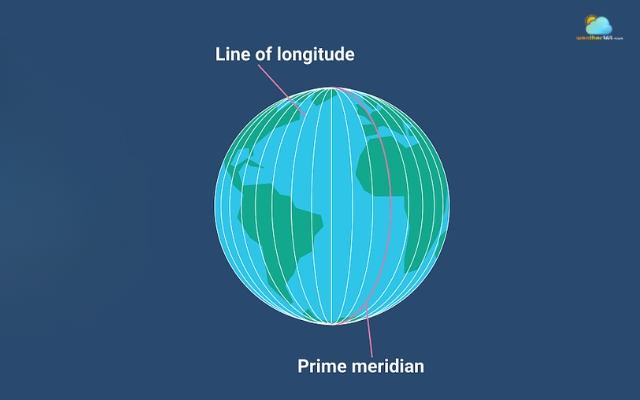
Longitude is measured in degrees (°), starting from the Prime Meridian (0°) - an imaginary line that runs from the North Pole to the South Pole and passes through Greenwich, England.
From this reference point, longitude extends up to 180° east and 180° west, covering the entire Earth.
Unlike latitude lines, which stay parallel, lines of longitude - often called meridians are a bit different. They run vertically from pole to pole and gradually get closer together as they approach the poles.
This means they are widest apart at the Equator and meet at the top and bottom of the Earth. This structure helps create a full coordinate grid when combined with latitude.
Time Travel
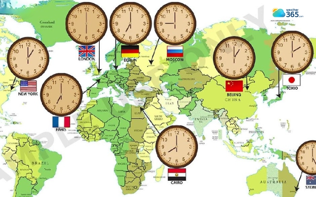
One of the most fascinating things about longitude is its direct connection to time.
Because the Earth rotates 360 degrees in 24 hours, every 15 degrees of longitude represents roughly one hour of time difference.
15 degrees of longitude represents one hour of time difference
This is the foundation of global time zones. When you travel east or west across longitudes, your local time changes accordingly.
That’s why flying from Vietnam to Europe or the United States often involves adjusting your watch and your sleep schedule.
Let’s take a look at some of the coordinated time zones worldwide:
Longitude range | Coordinated time zone (UTC) | Example city | Time differences (hours) |
105° to 120° East | UTC +8 | Beijing, China | +8 |
45° to 60° East | UTC +4 | Dubai, UAE | +4 |
15° to 30° East | UTC +2 | Athens, Greece | +2 |
0° to 15° East | UTC +1 | Berlin, Germany | +1 |
0° to 15° West | UTC ±0 | Greenwich, UK | 0 |
15° to 30° West | UTC -1 | Azores, Portugal | -1 |
30° to 45° West | UTC -2 | Cape Verde | -2 |
60° to 75° West | UTC -4 | New York, USA | -4 |
120° to 135° West | UTC -8 | Los Angeles, USA | -8 |
Importance of Longitude
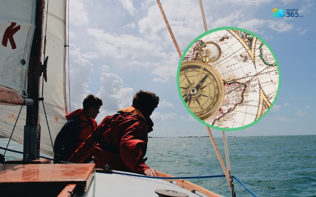
Historically, longitude was much harder to measure than latitude.
Early explorers could estimate latitude using the sun or stars, but determining longitude required precise timekeeping.
It wasn’t until the invention of accurate marine chronometers in the 18th century that sailors could reliably calculate their east–west position at sea.
This breakthrough completely transformed navigation and made long-distance ocean travel much safer.
Today, longitude remains essential in modern technology. Every time you use GPS on your phone, longitude works together with latitude to pinpoint your exact location.
Without longitude, you might know your general region north or south, but you wouldn’t be able to identify your precise position on Earth.
In essence, longitude is what allows us to measure the world from side to side. It not only helps us locate places accurately but also keeps global time organized.
Longitude is extremely important in navigation
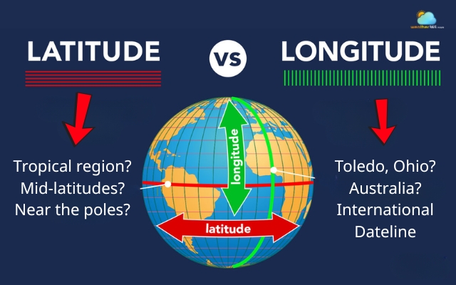
Difference between latitude and longitude
Many people confuse latitude and longitude because they’re always used as a pair, but each plays a very distinct role in helping us locate places on Earth.
Geographic Orientation and Purpose
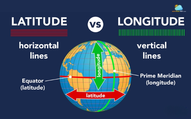
At the most basic level, the difference lies in what each coordinate measures.
Latitude is all about north–south position. It tells you how far a place is from the Equator, using horizontal lines that circle the Earth.
Longitude, on the other hand, measures east–west position, using vertical lines that run from pole to pole.
You can think of latitude as answering the question: “Am I closer to the North Pole or the South Pole?”
While longitude answers: “How far am I from the Prime Meridian?”
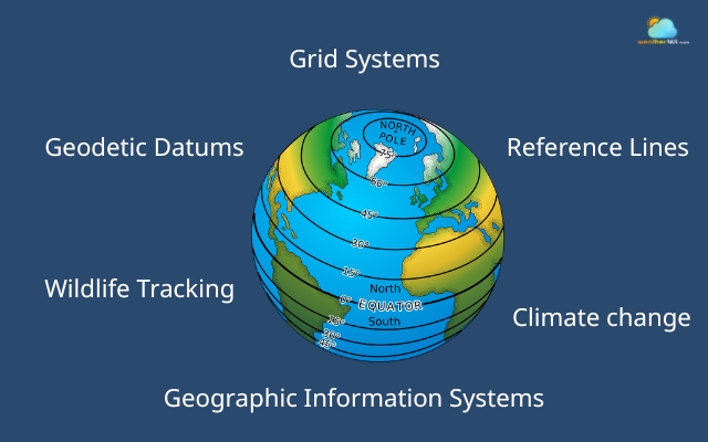
Together, they form a grid system that can pinpoint any location on Earth with precision. Without one, the other is incomplete, and you need both to define an exact place.
Longitude and latitude differ in what they measure
Impact on Navigation and Mapping
This difference becomes especially important in navigation.
Latitude helps determine your general position, whether you’re in a tropical region, mid-latitudes, or near the poles.
Longitude, however, is what allows you to refine that position and locate a specific point on the map.
Historically, sailors could calculate latitude relatively easily by observing the sun or stars.
Longitude was much harder and required accurate timekeeping, which made it the key to precise navigation.
In modern mapping, both coordinates are essential. Every location you search on a digital map is defined by a pair of latitude and longitude values.
Without this system, global navigation as we know it simply wouldn’t exist.
Latitude and longitude answer different questions
Influence on Time Keeping and Time Zones
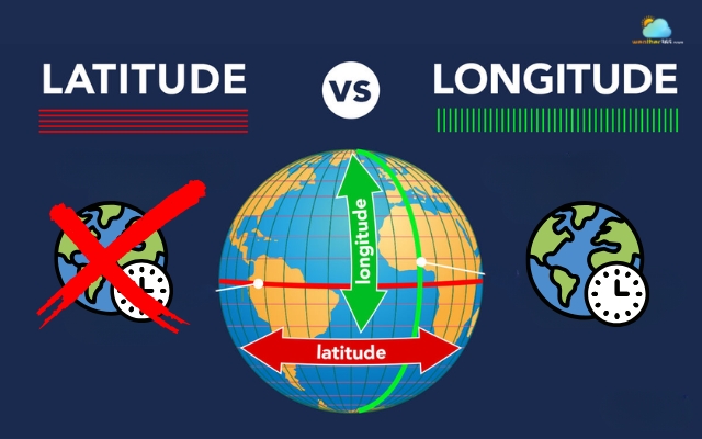
One of the biggest differences is how longitude affects time, while latitude does not.
Longitude is directly tied to time zones. Because the Earth rotates 360° in 24 hours, every 15° of longitude represents roughly one hour of time difference.
This is why traveling east or west changes your local time.
Latitude, in contrast, has no direct role in timekeeping.
However, it does influence how much daylight a place receives throughout the year, which indirectly affects daily life and seasonal patterns.
So if you’ve ever experienced jet lag after a long flight, you can thank longitude, not latitude, for that disruption.
Longitude affects time, latitude does not
Utilization in GPS Technology
In today’s world, the difference between latitude and longitude becomes most obvious in GPS technology.
GPS systems rely on both coordinates working together to create an exact “address” on Earth. Latitude narrows down your position vertically, while longitude locks in your horizontal location.
Combined, they allow satellites to calculate your precise position in real time.
Without longitude, your location would be vague, like knowing you’re somewhere along a horizontal band of the Earth.
Without latitude, you’d only know your east–west position. But together, they eliminate ambiguity completely.
This is why even the smallest error in either coordinate can place you in the wrong location, sometimes miles away from where you actually are.
Latitude | Longitude | |
Direction measured | North – South position | East – West position |
Line Orientation | Horizontal lines (run east–west) | Vertical lines (run north–south) |
Other Name | Parallels | Meridians |
Reference Line | Equator (0°) | Prime Meridian (0°) |
Range of Values | 0° to 90° North and South | 0° to 180° East and West |
Shape on Globe | Complete circles around the Earth | Half-circles connecting poles |
Parallelism | Always parallel, never meet | Converge at the poles |
Distance Between Lines | Constant (equal spacing) | Varies (widest at the Equator, zero at the poles) |
Number of Lines | 180 lines | 360 lines |
Hemisphere Relation | Same latitude = same hemisphere | Same longitude can cross hemispheres |
Impact on climate | Strong influence (climate zones) | No direct impact |
Impact time zones | No effect | Determines time zones |
Main use | Identifying climate zones and north–south position | Determining time and precise east–west position |
Role in Navigation | Helps estimate general location | Helps pinpoint exact location |
Use in GPS | Provides vertical positioning | Provides horizontal positioning |
Key Applications of Latitude and Longitude
In fact, we use latitude and longitude almost everywhere in our daily lives.
These coordinates are not just abstract lines on a map; they power many systems we rely on every day.
Navigation and Travel
One of the most obvious applications is navigation and travel.
Whether it’s airplanes crossing continents or ships moving through open oceans, latitude and longitude help determine exact positions in real time.
In the past, explorers depended on these coordinates to avoid getting lost at sea. Today, the same principle still applies, just with more advanced technology behind it.
Even when you follow directions on your phone, you are essentially moving from one coordinate point to another.
Latitude and longitude help determine exact positions
GPS and Digital mapping systems
This leads directly to their role in GPS and digital mapping systems.
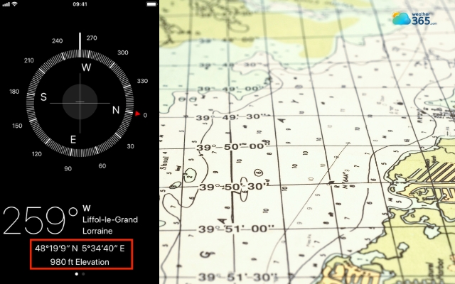
Every location you search on apps like Google Maps is defined by a pair of numbers: latitude and longitude.
These coordinates allow satellites to communicate with your device and pinpoint your exact position within seconds.
Without this system, features like live location sharing, ride-hailing, or even finding a nearby café wouldn’t be possible.
It’s easy to overlook, but every tap on a map relies on this global coordinate framework.
Location is defined by a pair of numbers
Weather forecasting
Latitude and longitude are also essential in weather forecasting. Meteorologists use them to track the movement of storms, pressure systems, and temperature changes across the planet.
For example, when you hear that a storm is forming at a specific coordinate, that’s how scientists monitor its path and predict where it might go next.
Latitude, in particular, helps explain climate patterns, while longitude helps map the movement of weather systems over time.
But, how accurately can they predict the weather? Discover now The most accurate weather forecast!
Latitude and longitude are used to track the movement of storms
Scientific research & environmental studies
Another important application is in scientific research and environmental studies.
Researchers use geographic coordinates to record exact locations for everything from wildlife tracking to ocean currents and climate change observations.
Because latitude and longitude provide a universal reference system, scientists from different countries can share and compare data with accuracy and consistency.
Longitude and latitude can be applied in scientific research and environmental studies
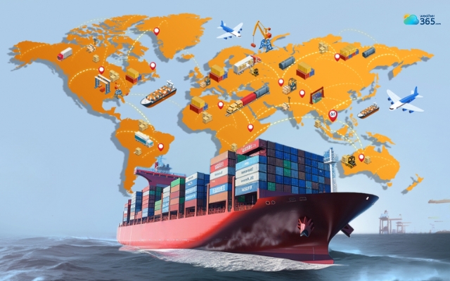
Global Communication and Logistics
They also play a key role in global communication and logistics.
From international shipping routes to aviation systems, coordinates help ensure that goods and people move efficiently across the world.
Even undersea cables and satellite networks depend on precise geographic positioning to function correctly.
Longitude and latitude play a key role in global logistics
In conclusion
The difference between latitude and longitude is the key to understanding how we locate places on Earth with precision. While latitude shows north–south position and longitude defines east–west location, together they power maps, navigation, and GPS, making it easier than ever to explore and connect with the world around us.
Frequently Asked Questions (FAQs)
Related post

Isobars On A Weather Map: What Are They and How To Read Them Properly

How to Read a Weather Map: Isobars, Fronts, Cloud Cover And Pressure

0 Comment
Leave a comment
Your email address will not be published. Required fields are marked *