What Is a Polar Vortex? Definitions, Causes, and Weather Impacts
What is a polar vortex, and why does it sometimes unleash brutal cold far beyond the Arctic? You’ve likely heard the term during extreme winter events, but its true meaning is often misunderstood. Let’s find out useful things in our guide. Diving in!
What is a polar vortex?
- What is a Polar Vortex?
- What causes a Polar Vortex?
- It Starts With a Strong Temperature Contrast
- Stratospheric Winds Keep It Spinning
- Atmospheric Waves Can Disrupt It
- Sudden Stratospheric Warming - The Key Trigger
- How does the Polar Vortex affect winter weather?
- Does the Polar Vortex cause extremely cold temperatures in the US?
- Does the Polar Vortex Signal Upcoming Cold Weather?
What is a Polar Vortex?
At its core, if you’re wondering what is a polar vortex, the simplest way to understand it is this:
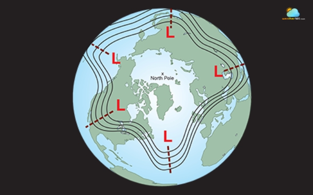
It’s a massive, spinning system of cold air and low pressure that sits over the Earth’s poles, especially the Arctic.
A polar vortex is a low-pressure area
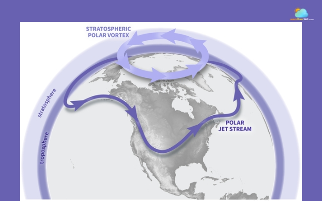
The polar vortex is not a storm you can see on the ground.
Instead, it exists high up in the atmosphere, mainly in a layer called the stratosphere, far above where everyday weather happens.
Up there, strong winds circle around the pole, forming a kind of invisible barrier that keeps extremely cold Arctic air contained.
The word “vortex” simply means spinning air. In this case, the air rotates in a large circular pattern, helping trap cold air near the poles.
One common misconception is that the polar vortex is a rare or new phenomenon.
In reality, it has always existed as a natural part of Earth’s atmospheric system. It just gets more attention today because of its link to extreme winter weather.
The vortex is present all year, but it behaves differently depending on the season.
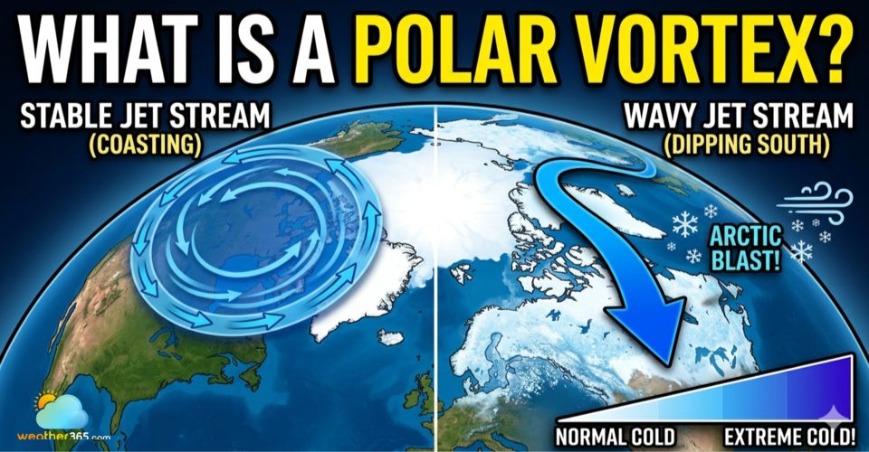
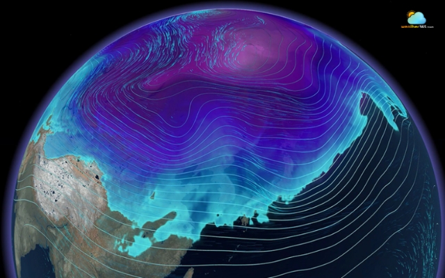
Another important detail is that the polar vortex is connected to the jet stream, a fast-moving current of air that flows around the Northern Hemisphere.
When the vortex is stable, the jet stream tends to stay relatively straight, keeping weather patterns predictable.
But when the vortex becomes disturbed, the jet stream can become wavy, allowing cold Arctic air to dip much farther south than usual.
Learn everything about the jet stream here!
What causes a Polar Vortex?
To really understand what causes a polar vortex, you need to look at how temperature and atmospheric motion interact on a global scale.
It Starts With a Strong Temperature Contrast
The main driver behind the polar vortex is the huge difference in temperature between the Arctic and the equator.
During winter, the Arctic receives little to no sunlight, causing the air to become extremely cold and dense.
At the same time, regions closer to the equator stay relatively warm.
This contrast creates strong winds in the upper atmosphere that begin to spin around the pole, forming the vortex.
In simple terms, the greater the temperature difference, the stronger and more stable the polar vortex becomes.
The temperature difference between the Arctic and the equator
Stratospheric Winds Keep It Spinning
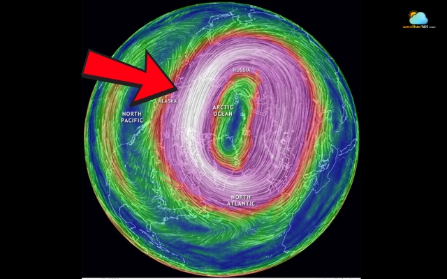
The polar vortex exists mainly in the stratosphere, and it is maintained by fast-moving winds that circle from west to east.
These winds act like a “wall,” keeping cold Arctic air locked in place.
As long as these winds remain strong, the vortex stays compact and stable. But the atmosphere is never perfectly calm-and that’s where things start to get interesting.
The stratosphere is “kept” by fast-moving winds
Atmospheric Waves Can Disrupt It
Large-scale atmospheric movements, often called planetary waves, travel upward from the lower atmosphere into the stratosphere.
When these waves become strong enough, they can disturb the circular motion of the vortex.
You can imagine it like spinning water in a bowl; if you suddenly push or shake it, the smooth rotation becomes uneven.
The same thing happens to the polar vortex when these waves interfere.
Planetary waves can disturb vortex motion
Sudden Stratospheric Warming - The Key Trigger
One of the most important causes of polar vortex disruption is a phenomenon known as sudden stratospheric warming (SSW).
This happens when:
Temperatures in the stratosphere rise rapidly within just a few days
The strong winds of the vortex weaken, slow down, or even reverse direction
The vortex becomes distorted, stretched, or split
These events occur roughly every couple of years and are a major reason why the polar vortex sometimes “breaks down.”
When that happens, the cold air that was once contained can move southward, affecting weather far from the Arctic.
Dig deeper into the stratospheric warming here!
Stratospheric warming causes polar vortex disruption
How does the Polar Vortex affect winter weather?
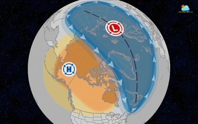
The polar vortex plays a key role in shaping winter weather, mainly by controlling where the coldest Arctic air stays or where it moves.
When the vortex is strong and stable, it keeps freezing air trapped near the North Pole, leading to more predictable winter conditions in many regions.
But when it weakens or becomes unstable, that cold air can spill southward, causing sudden cold waves and sharp temperature drops in places far from the Arctic.
This shift also affects the jet stream, making it more wavy and less stable.
As a result, weather patterns become more extreme and unpredictable, with cold air pushing south and warmer air moving north.
When this cold air interacts with moisture, it can also increase the chances of heavy snowfall and winter storms.
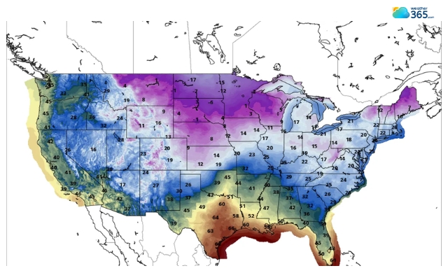
Does the Polar Vortex cause extremely cold temperatures in the US?
The short answer is: yes, but not directly in the way many people think.
The polar vortex doesn’t create cold air from scratch. That freezing air already exists over the Arctic every winter.
The cold air exists over the Arctic every winter
What the vortex does is act like a control system, deciding whether that cold air stays near the pole or moves south into places like the United States.
When the vortex is strong and stable, it keeps that bitter cold air contained. In this case, winters in the US may still be cold, but they are generally more typical and predictable.
The real impact happens when the polar vortex weakens, stretches, or splits.
During these disruptions, the barrier holding Arctic air in place breaks down.
This allows large masses of extremely cold air to plunge southward into the US, sometimes reaching areas that don’t usually experience such low temperatures.
That’s when you see headlines about record-breaking cold, frozen cities, and dangerous wind chills.
However, it’s important to keep things in perspective. Not every cold wave in the US is caused by the polar vortex.
Multiple factors, including pressure systems, ocean patterns, and the behavior of the jet stream influence winter weather.
he polar vortex is just one, albeit a powerful piece of that puzzle.
So, while the polar vortex can absolutely trigger extreme cold outbreaks in the US, it works more like a gatekeeper than a source.
When it loses stability, it opens the door for Arctic air to move south, turning an ordinary winter into an unusually harsh one.
Does the Polar Vortex Signal Upcoming Cold Weather?
The polar vortex can act as an early warning sign of potential cold weather, but it’s not a simple yes-or-no indicator.
When scientists observe that the polar vortex is weakening, stretching, or shifting position, it often suggests that the atmosphere is becoming less stable.
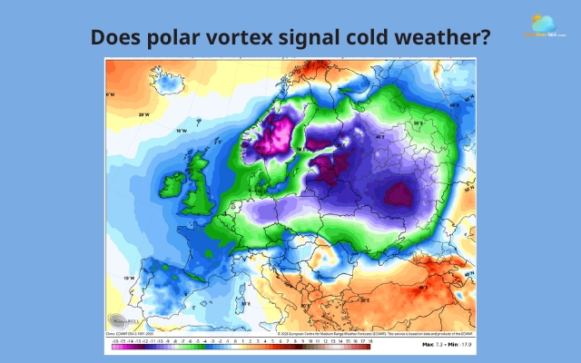
The polar vortex can be a signal of cold weather
This instability increases the chance that cold Arctic air could move southward in the coming days or weeks.
However, this doesn’t mean cold weather will happen immediately or affect every region.
The atmosphere is complex, and many factors, like the jet stream, pressure systems, and moisture levels, work together to shape actual weather conditions on the ground.
In other words, a disrupted polar vortex is more like a signal of higher risk rather than a guaranteed forecast.
Meteorologists use it as one piece of the puzzle to anticipate broader winter patterns, especially when predicting cold outbreaks across North America, Europe, or Asia.
So, while the polar vortex can hint at upcoming cold weather, it’s best understood as a trend indicator, not a precise predictor of when and where temperatures will drop.
The Bottom Line
A polar vortex is a powerful atmospheric system that plays a key role in winter weather. While it usually keeps cold air trapped near the Arctic, disruptions can send freezing temperatures far south. Understanding how it works helps explain extreme cold waves and why winter weather can sometimes feel so unpredictable.
Frequently Asked Questions (FAQs)
Related post

What Is The GFS Weather Model: Accuracy, Uses & Comparison Explained

What Is Stratospheric Warming? The Hidden Force Behind Extreme Cold

0 Comment
Leave a comment
Your email address will not be published. Required fields are marked *