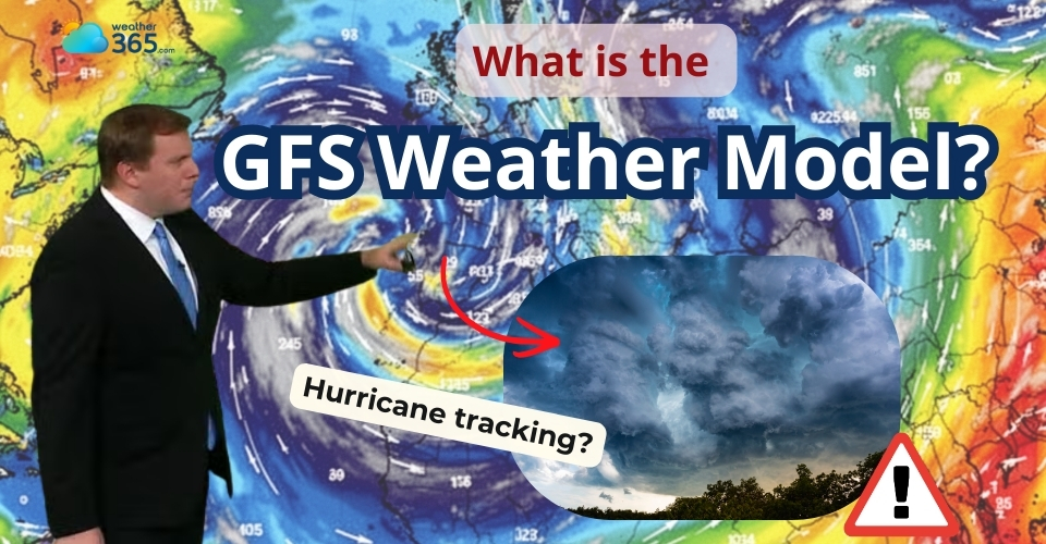
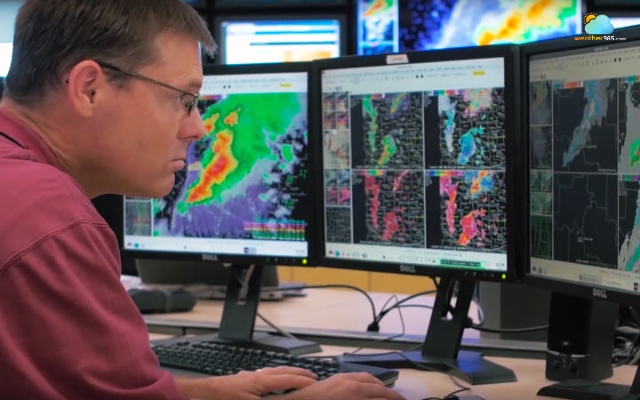
What Is The GFS Weather Model: Accuracy, Uses & Comparison Explained
What is the GFS weather model, and why do so many weather forecasts rely on it? If you’ve ever checked a weather app and wondered where those predictions come from, the answers are right here!. Scrolling down to learn how the GFS model works, why it matters, and how accurate it really is.
What is the GFS weather model?
- What Is The GFS Weather Model?
- Main Features Of The GFS Weather Model
- Common Usages of the GFS Weather Model
- How Does The GFS Weather Model Work?
- Collecting Global Weather Data
- Data Assimilation
- Running Atmospheric Simulations
- Producing Forecast Runs
- Why Is The GFS Weather Model Important?
- Severe Weather Warning
- Data Accessibility
- Scientific/Climate Research
- Applications of GFS
- ECMWF vs GFS: Which is More Accurate?
- Difference between ECMWF and GFS
- Which is More Accurate?
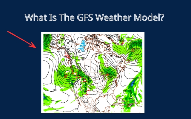
What Is The GFS Weather Model?
The GFS weather model (Global Forecast System) is one of the most widely used tools in modern weather forecasting.
It is developed and operated by the National Centers for Environmental Prediction (NCEP), which is part of the National Oceanic and Atmospheric Administration (NOAA) in the United States.
In simple terms, the GFS weather model is a computer system that simulates the Earth’s atmosphere to predict future weather conditions.
It collects large amounts of weather data from around the world and uses complex calculations to estimate how the atmosphere will change over the next few hours and days.
The GFS weather model is a modern tool in weather forecasting
Main Features Of The GFS Weather Model
What makes the GFS weather model such an important tool in modern forecasting?
Let’s take a closer look at the key characteristics that allow this model to simulate weather patterns across the entire planet.
Global coverage
Unlike regional forecasting models that focus only on a specific country or continent, the GFS weather model simulates atmospheric conditions across the entire Earth.
This global coverage allows meteorologists to track large-scale weather systems such as the jet stream, major pressure systems, and developing tropical storms.
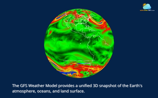
The GFS simulates atmospheric conditions across the globe
Long forecast range
The GFS weather model can produce weather forecasts up to 16 days in advance, which makes it useful for medium- and long-range predictions.
Although forecasts become less certain the further they look into the future, the model still helps scientists recognize possible weather trends and upcoming patterns.
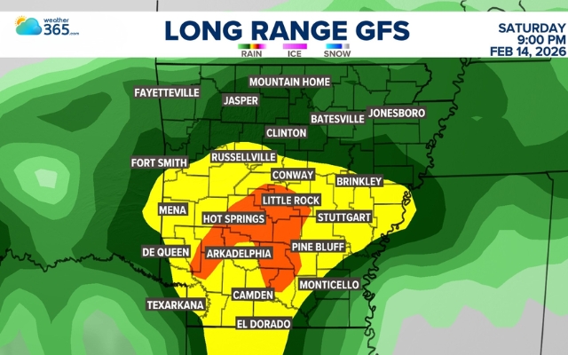
The GFS model can generate weather predictions up to 16 days
Four times a day updated
The GFS weather model is also updated four times a day. These updates, called forecast runs, happen at 00Z, 06Z, 12Z, and 18Z.
Frequent updates allow the model to quickly include new weather observations and adjust its predictions when atmospheric conditions change.
Massive global datasets
The GFS weather model collects observations from many sources, including satellites, weather balloons, aircraft sensors, ocean buoys, radar systems, and thousands of ground weather stations.
By combining all this information, the model creates a detailed picture of the current atmosphere before predicting how weather conditions may change in the future.
Common Usages of the GFS Weather Model
Because of its global coverage and frequent updates, the GFS weather model supports many different forecasting activities.
Hurricane Tracking
One major use of the GFS weather model is tracking storms such as hurricanes and tropical storms.
Meteorologists use the model to estimate how these storms may move across the ocean and which regions might be affected.
Although no single model can predict a storm’s path perfectly, GFS simulations are an important tool in hurricane forecasting.
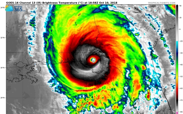
The GFS weather model can track hurricanes and storms
Marine Forecasting
The model is also widely used for marine weather forecasting.
Sailors, shipping companies, and offshore industries rely on predictions of wind, pressure, and ocean conditions to plan safe routes at sea.
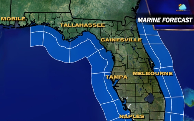
The GFS is a fundamental tool for marine forecasting
AI Integration
In recent years, data from the GFS weather model has also become valuable for modern weather platforms and AI-based forecasting tools.
Many weather apps now combine GFS outputs with machine learning techniques or other forecast models to produce more detailed and accurate predictions.
NOAA launched an AI GFS project
How Does The GFS Weather Model Work?
Are you curious how the GFS weather model actually turns raw atmospheric data into weather forecasts?
Let’s take a closer look at the process that allows the GFS model to predict weather days in advance.
Collecting Global Weather Data
The process begins with collecting observations from around the world.
Weather conditions are constantly monitored by a large network of instruments, such as:
satellites that observe Earth from space
ground weather stations that measure local conditions
ocean buoys that collect data from the sea
aircraft sensors that record atmospheric measurements
These tools provide information about temperature, wind, humidity, air pressure, and cloud formation around the world.
The GFS model uses this large amount of data to create a clear picture of the atmosphere at a specific moment in time.
Without this global network of observations, weather models would not have enough information to start their forecasts.
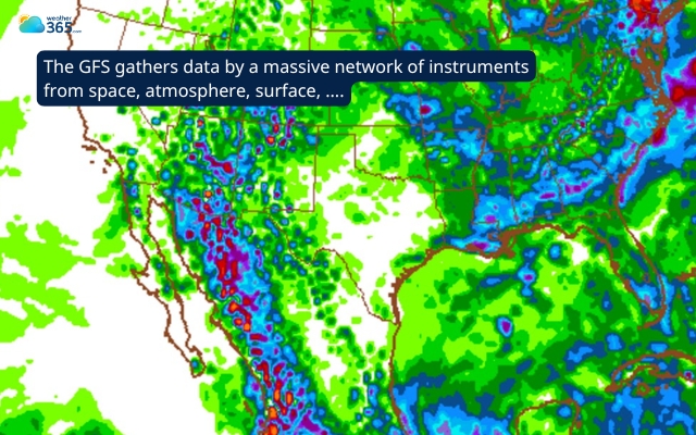
The GFS collects millions of data points from across the planet
Data Assimilation
Once observations are collected, the next step is called data assimilation.
This stage combines real weather observations with previous forecasts to estimate the current state of the atmosphere.
Because weather data is not collected evenly around the world, the model needs to combine information from many different sources to create a clear global picture of the atmosphere.
This starting point is very important. If the model begins with inaccurate data, the forecast can become less accurate over time.
NCEP Global Data Assimilation System GDAS
Running Atmospheric Simulations
After the current state of the atmosphere is determined, the GFS model starts predicting how the weather will change over time.
To do this, the Earth is divided into a large 3D grid.
Each grid point represents a small part of the atmosphere where the model calculates things like air pressure, temperature, humidity, wind speed, and wind direction.
Using the laws of physics, powerful computers calculate how these factors affect each other.
For example, temperature differences can change air pressure, which then creates wind and can lead to cloud formation.
The GFS model also connects several Earth systems, including the atmosphere, oceans, land surfaces, and sea ice. This helps the model simulate weather in a more realistic way.
Because the atmosphere is very complex, these calculations must be repeated millions of times across the entire planet.
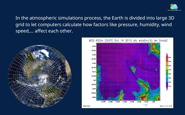
The GFS runs atmospheric simulations to predict the change in the weather
Producing Forecast Runs
The full simulation process runs four times a day. Each new run uses the latest weather observations to update the forecast.
Every run produces predictions for up to 16 days ahead, including information about temperature, precipitation, wind patterns, and other weather conditions.
The model creates forecast results at regular time intervals, hourly for the first few days, and then every few hours after that.
These results are used by meteorologists, weather agencies, and forecasting platforms to create the weather reports people see in apps, news programs, and aviation forecasts.
You may be interested in: How to read a weather map
The simulation process runs four times a day to update the forecast
Why Is The GFS Weather Model Important?
Modern weather forecasting relies heavily on computer models, and the GFS weather model is one of the most important.
Because it analyzes weather conditions across the entire planet, the GFS has become a widely used tool for understanding and predicting weather patterns around the world.
Severe Weather Warning
One of the biggest reasons the model is so important is early warning for severe weather.
The model helps scientists detect the possible formation of extreme weather events such as hurricanes, winter storms, and heatwaves several days in advance.
By studying the model’s results, meteorologists can spot early warning signs and alert communities sooner.
This early warning is very important for disaster preparation, giving governments, emergency teams, and residents time to prepare before severe weather arrives.
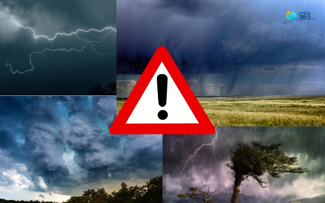
The GFS weather model is crucial for severe weather warnings
Data Accessibility
The GFS model is also valuable because it provides open and widely accessible data.
Developed by the National Oceanic and Atmospheric Administration, its forecast data is freely available to researchers, weather agencies, and technology companies.
This openness allows many weather websites, forecasting platforms, and mobile apps to use GFS outputs as part of their prediction systems.
In other words, when you check the weather on a popular app, there is a good chance that GFS data is helping power that forecast.

The GFS provides open and widely accessible data
Scientific/Climate Research
Another reason the GFS weather model is important is its role in scientific research and climate studies.
Scientists often use GFS data to study how the atmosphere behaves, analyze weather patterns, and improve forecasting methods.
Because the model runs continuously and produces large amounts of data, it gives researchers valuable insights into how the atmosphere changes over time.
Scientists use GFS data to conduct research
Applications of GFS
The GFS weather model data is used in many real-world situations beyond daily weather forecasts.
Governments, researchers, and industries rely on GFS outputs to understand upcoming weather patterns and make better decisions.
Let’s look at some of the most common ways this model is applied in practice.
Web indexing and search
Large data systems make it possible to process enormous amounts of web content for search engines.
By distributing data across many servers, the system can store and organize billions of web pages efficiently.
Big data processing (MapReduce)
Another key application is big data processing, often using frameworks such as MapReduce.
This approach splits large datasets into smaller pieces and processes them across many machines at the same time.
Storage for Large-scale services
Modern online platforms generate huge amounts of information every day.
Distributed storage systems are designed to handle this scale by spreading data across multiple servers.
Log file analysis and storage
Large computing systems generate many log files that record system activities, user actions, and performance data.
Moreover, large-scale systems can use distributed storage to keep data safe and reliable.
These logs help engineers monitor how the system is running, find errors, and improve overall performance.
And by storing multiple copies of important files on different servers, the system can still recover the data even if one machine stops working.

The GFS has numerous applications across sectors
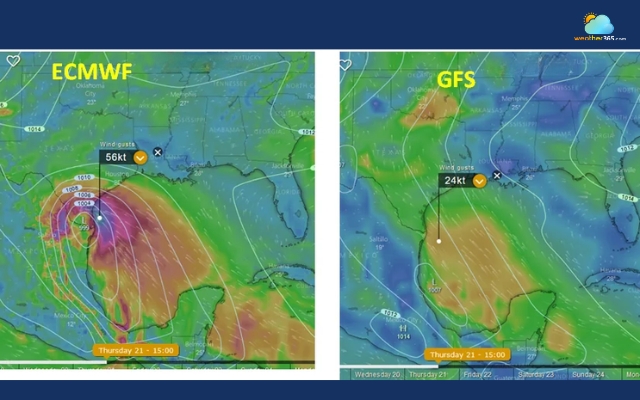
ECMWF vs GFS: Which is More Accurate?
When people compare weather forecast models, the discussion usually focuses on two major systems: the GFS weather model and the ECMWF weather model.
The ECMWF model was developed by the European Centre for Medium-Range Weather Forecasts and is often called the “Euro model” by meteorologists.
Like the GFS, ECMWF is a global numerical weather prediction system.
It collects atmospheric data from satellites, weather stations, aircraft, and ocean buoys, then uses powerful computers to simulate how the atmosphere may change.
One reason the ECMWF model is highly respected in meteorology is its strong performance in medium-range forecasts, usually from about three to ten days ahead.
Because of this, many meteorologists consider it one of the most reliable global weather models available today.
Difference between ECMWF and GFS
Although both models aim to predict global weather patterns, there are several differences in how they operate.
Difference between the GFS and ECMWF
Updating frequency
One noticeable difference is update frequency.
The GFS model runs four times per day, which means it can respond quickly to newly observed weather conditions.
ECMWF, on the other hand, usually runs two major forecast cycles daily, focusing more on precision than frequency.
Data Accessibility
Another difference involves data accessibility.
The GFS model is produced by the National Oceanic and Atmospheric Administration, and its forecast data is largely open and freely available.
This openness allows weather apps, research groups, and forecasting platforms to easily integrate GFS data.
ECMWF data, however, is more restricted and often requires licensing for full access.
As a result, its outputs are typically used by professional meteorological agencies or specialized forecasting services.
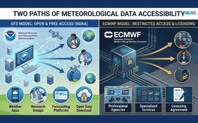
The GFS has more open data availability than the ECMWF
Resolution and Computing Resources
There are also differences in model resolution and computing power between the GFS weather model and the ECMWF weather model.
The ECMWF model has traditionally used very powerful supercomputers and higher-resolution simulations. This allows it to capture smaller atmospheric details more accurately in some situations.
The GFS model has improved a lot in recent years. However, in the past, it sometimes ran at a slightly lower resolution than ECMWF.
Which is More Accurate?
In many verification studies, the ECMWF weather model has often shown slightly higher accuracy for medium-range forecasts, especially for predictions beyond five to seven days.
Because of this, meteorologists frequently check ECMWF results when analyzing longer-term weather patterns.
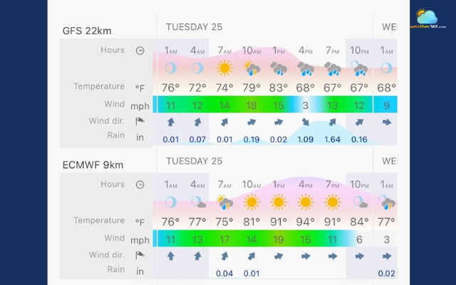
Weather forecast of GFS and ECMWF
However, this does not mean the GFS weather model is unreliable. In fact, GFS is still extremely valuable because it:
updates more frequently
provides fully open data
covers the entire globe
is widely used in many weather forecasting systems
Since every weather model has its own strengths and weaknesses, professional forecasters rarely rely on just one model.
Instead, they compare several models, including both GFS and ECMWF, to look for consistent trends and increase forecast confidence.
Discover the most accurate weather forecast!
Frequently Asked Questions (FAQs)
Related post

0 Comment
Leave a comment
Your email address will not be published. Required fields are marked *