What Is A Jet Stream? Complete Guide to Jet Streams and Their Role in Weather
What is a jet stream? And have you ever wondered why storms suddenly change direction or why some flights arrive much earlier than expected? High above the Earth, powerful rivers of wind control many of these events. Let’s explore how jet streams work and why they matter more than you might think. Diving in!
Discover what is a jet stream
- What is A Jet Stream?
- Types of Jet Streams
- Polar Front Jet Streams
- Subtropical Jet Streams
- Tropical Easterly Jet Stream
- Polar Night Jet Stream
- Low-level Jet Streams
- What Causes Jet Streams?
- Uneven heating
- The Coriolis effect
- Temperature gradients
- Atmospheric pressure
- Impact of A Jet Stream
- Air travel
- Weather/Climate
- How Do We Predict Weather Through The Jet Stream?
What is A Jet Stream?
So what is a jet stream, and why do meteorologists talk about it so often?
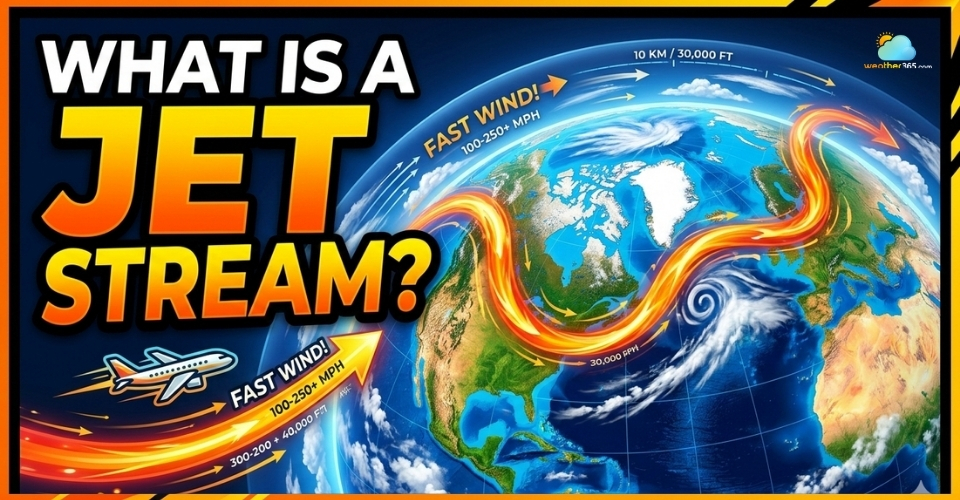
A jet stream is a narrow band of very strong winds that flows high in the atmosphere.
These winds move rapidly around the planet, usually from west to east, and can reach speeds of more than 160–320 km/h (100–200 mph).
In simple terms, a jet stream in weather is like a fast-moving river of air that travels several kilometers above the Earth's surface.
Instead of water, this “river” carries air masses across continents and oceans, helping to shape weather patterns around the world.
Jet streams are strong winds flowing high in the atmosphere
Where Are Jet Streams Located?
Jet streams are typically found in the upper troposphere, about 9–16 kilometers (6–10 miles) above the Earth.
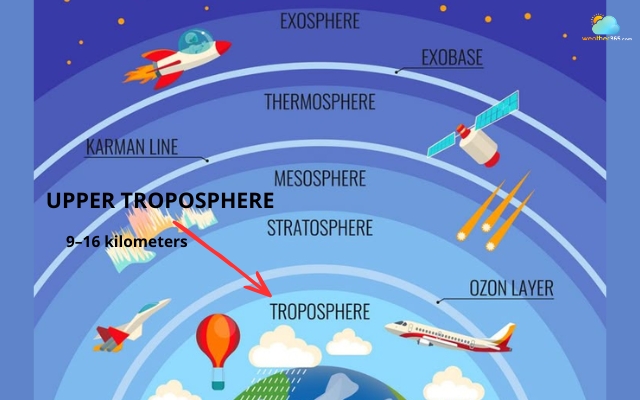
Jet streams are often spotted in the upper troposphere
They form near the boundary between large air masses that have different temperatures.
Most jet streams occur in the mid-latitudes, where cold polar air meets warmer tropical air.
Because of this temperature contrast, strong winds develop and flow along these atmospheric boundaries.
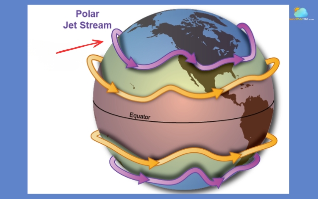
There are usually two main jet streams in each hemisphere:
The polar jet stream, located closer to the poles
The subtropical jet stream, located nearer to the tropics
Both of these wind currents play an important role in shaping global weather systems.
Types of Jet Streams
Although many people think there is only one global jet stream, the atmosphere actually contains several different types of jet streams.
Each one forms in a specific region of the atmosphere and plays a different role in shaping weather patterns.
These powerful wind currents are mainly classified based on their location, altitude, and the atmospheric conditions that create them.
You may be interested in: Types of wind
Some influence daily weather systems, while others appear only under special seasonal or polar conditions.
Below are the most important types of jet streams meteorologists study.
Polar Front Jet Streams
The polar jet stream is the strongest and most influential jet stream on Earth.
It forms where cold polar air meets warmer mid-latitude air, creating a sharp temperature contrast.
This jet stream usually flows between 45° and 60° latitude in both the Northern and Southern Hemispheres.
Because the temperature difference between these air masses can be very large, the resulting winds become extremely powerful.
The polar jet stream often flows between 45° and 60° latitude
Polar front jet streams play a major role in weather forecasting because they help guide storm systems and low-pressure areas.
When the jet stream dips southward, colder air can move into lower latitudes, often bringing winter storms or cold outbreaks.
When it shifts northward, warmer conditions may develop.
Subtropical Jet Streams
The subtropical jet stream forms closer to the tropics, usually around 30° latitude in both hemispheres.
It develops near the boundary between tropical warm air and the slightly cooler air of the mid-latitudes.
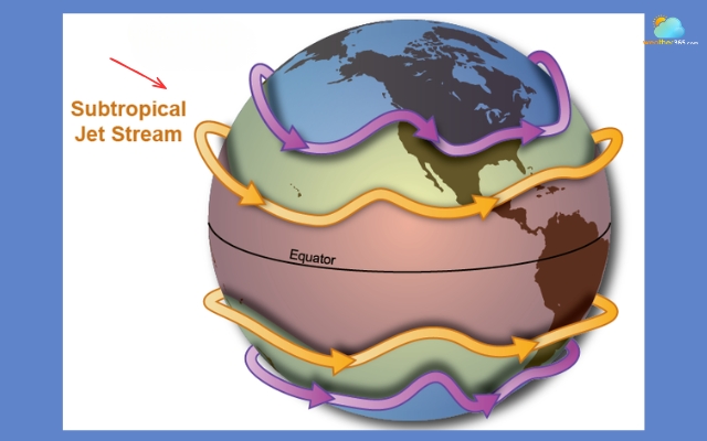
The subtropical jet stream carries moisture across continents
Unlike the polar jet stream, which is driven mainly by strong temperature contrasts, the subtropical jet is influenced more by large-scale atmospheric circulation patterns.
This type of jet stream typically flows at higher altitudes than the polar one.
It tends to be stronger during the winter months, when global atmospheric circulation patterns become more intense.
The subtropical jet stream is important because it can help transport moisture and energy across continents, sometimes contributing to heavy rainfall events or large storm systems.
Tropical Easterly Jet Stream
The tropical easterly jet stream is quite different from most other jet streams because it flows from east to west, rather than west to east.
This jet stream forms mainly during the summer months in the Northern Hemisphere, particularly over South Asia and parts of Africa.
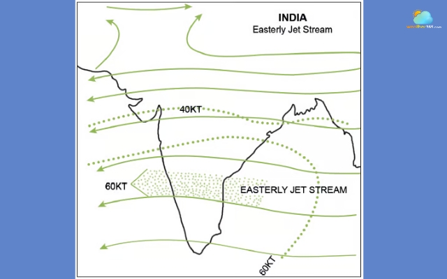
The tropical easterly jet stream often forms during the summer months
It develops as strong heating over land areas creates large pressure differences in the upper atmosphere.
One of the most well-known roles of the tropical easterly jet is its connection to the South Asian monsoon system.
When the jet becomes strong and well-established, it can help support the large-scale circulation patterns that bring seasonal rainfall to countries such as India.
Because of this relationship, scientists often study the jet stream to better understand monsoon strength and seasonal climate patterns.
Polar Night Jet Stream
The polar night jet stream forms high above the Arctic and Antarctic regions during the polar winter, when these areas experience months of darkness.
Without sunlight, the polar atmosphere cools rapidly, creating a strong temperature contrast between the extremely cold polar air and the relatively warmer air farther south.
This contrast produces powerful winds that circulate the poles in the upper atmosphere.
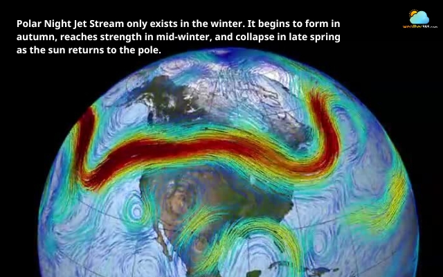
The polar night jet stream only exists in the winter
The polar night jet is closely linked to the polar vortex, a large system of cold air that spins around the poles during winter.
When this system weakens or becomes unstable, it can sometimes allow cold polar air to move southward, leading to extreme winter weather in lower latitudes.
Although it exists far above the surface, the polar night jet can still influence long-term climate patterns and winter weather events.
Low-level Jet Streams
Not all jet streams occur high in the atmosphere. Some develop much closer to the Earth's surface, and these are known as low-level jet streams.
Low-level jets usually form about 1–3 kilometers above the ground and often occur at night.
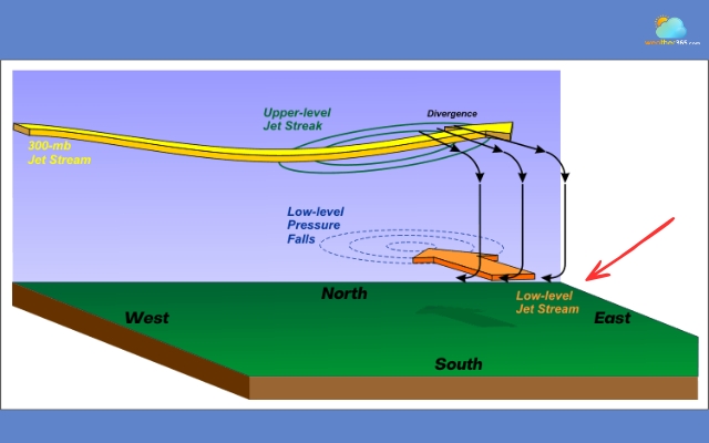
The low-level jet stream forms about 1–3 kilometers above the ground
They develop when surface cooling changes wind patterns and reduces friction near the ground, allowing winds slightly above the surface to accelerate.
One well-known example is the Great Plains low-level jet in North America.
This wind current transports warm, moist air from the Gulf of Mexico northward into the central United States.
Low-level jet streams are especially important because they can influence thunderstorm development, heavy rainfall events, or even regional climate patterns.
Even though they are weaker than upper-atmosphere jet streams, they still play a significant role in shaping local weather conditions.
What Causes Jet Streams?
Jet streams do not appear randomly in the atmosphere.
They form because of several large-scale atmospheric processes that control how air moves around the planet.
Uneven heating
One of the main reasons jet streams exist is uneven heating from the Sun.
The Earth does not receive the same amount of solar energy everywhere. ơ
Regions near the equator receive much more heat, while the polar regions receive much less.
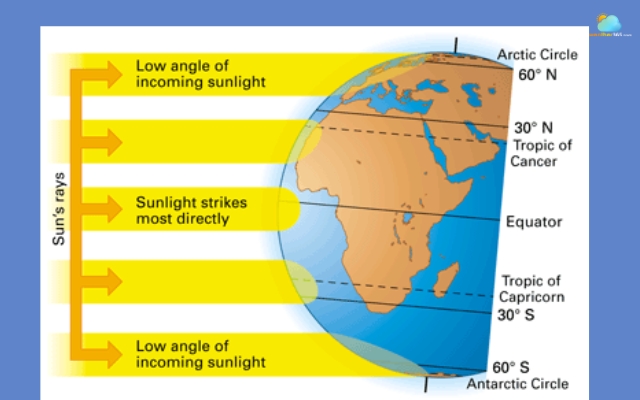
Different places on Earth receive different amounts of sunlight
Because of this imbalance, the atmosphere constantly tries to redistribute heat.
Warm air near the equator becomes lighter and rises, while colder air near the poles is denser and sinks.
As these air masses move and interact, large-scale wind currents begin to develop high in the atmosphere.
Where warm tropical air meets colder polar air, strong air currents form in the upper troposphere. These powerful currents eventually organize into the narrow, fast-flowing bands known as jet streams.
In simple terms, jet streams are part of the planet’s natural system for moving heat from warmer regions to cooler regions.
The Coriolis effect
Another key factor shaping jet streams is the Coriolis effect, which results from the Earth’s rotation.
As air moves across the planet, the spinning Earth causes that air to deflect from its original path.
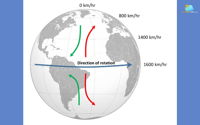
The Coriolis effect is an effect caused by the Earth's rotation
In the Northern Hemisphere, moving air curves to the right, while in the Southern Hemisphere, it curves to the left.
Without the Coriolis effect, air would simply move directly from warm areas toward cold areas. Instead, the rotation of the Earth bends these air flows sideways.
This deflection causes winds to align mostly west to east, which is why most jet streams move in that direction.
Temperature gradients
Jet streams are also driven by temperature gradients, which means sharp differences in temperature between neighboring air masses.
When warm and cold air masses meet, the contrast in temperature creates a strong boundary in the atmosphere.
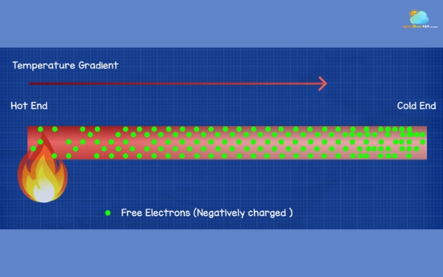
The temperature drives almost all wind on Earth
At these boundaries, the difference in air density and pressure becomes significant, causing winds to accelerate.
The stronger the temperature contrast, the faster the resulting winds can become.
For example, during winter, the temperature difference between the equator and the poles becomes larger.
As a result, the polar jet stream often becomes stronger and faster in winter than in summer.
Atmospheric pressure
Finally, differences in atmospheric pressure play an important role in the formation of jet streams.
Air naturally moves from areas of high pressure toward areas of low pressure. When strong pressure differences occur across a region, the air flows more rapidly.
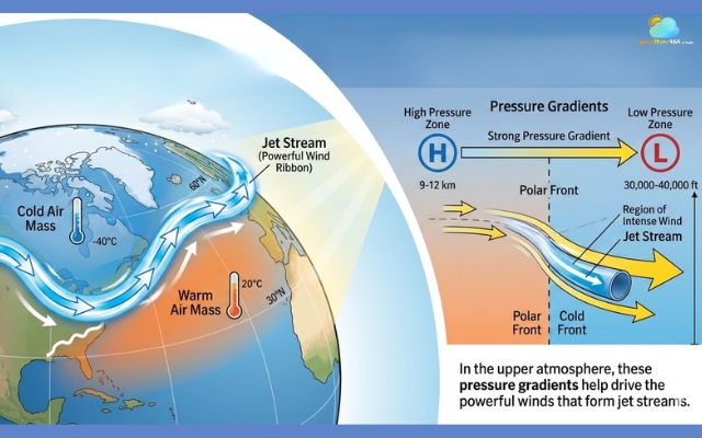
Atmospheric pressure causes the jet stream to form
In the upper atmosphere, these pressure gradients help drive the powerful winds that form jet streams.
Because pressure differences are often biggest along the boundaries between warm and cold air masses, jet streams tend to form along these same boundaries.
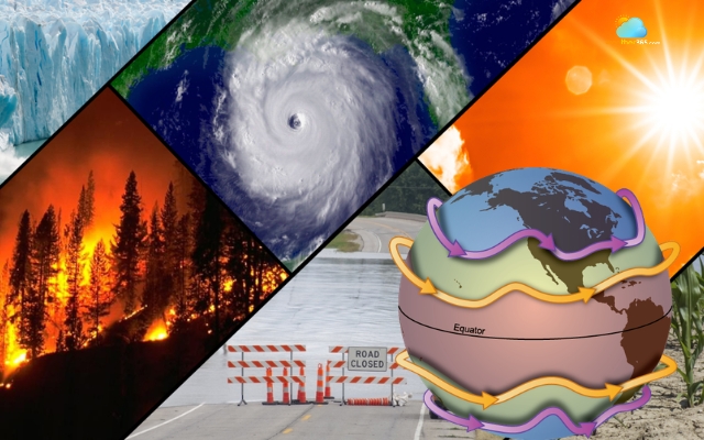
Impact of A Jet Stream
Jet streams are not just powerful winds high in the atmosphere; they have a major influence on many things happening on Earth, especially aviation and weather patterns.
Because they move extremely fast and stretch across continents, these air currents act like invisible highways that guide storms, affect climate conditions, and even influence how airplanes travel.
Air travel
Jet streams play an important role in modern aviation because they occur at roughly the same altitude where many commercial aircraft fly.
Most long-distance flights cruise in the mid to upper troposphere, about 9–12 km above Earth, which is the same region where jet streams exist.
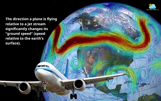
The jet stream can change the plane’s ground speed
When an airplane flies in the same direction as the jet stream, the strong tailwind can push the aircraft forward. This extra boost allows planes to travel faster and burn less fuel.
Learn more about wind speed and direction here!
That is why many transcontinental flights from west to east often have shorter travel times.
However, flying against the jet stream can have the opposite effect.
Headwinds from the jet stream slow aircraft down and increase fuel consumption. Airlines must carefully plan flight routes to avoid strong opposing winds whenever possible.
Another challenge associated with jet streams is turbulence.
Because wind speeds within the jet stream can change quickly over short distances, aircraft may experience clear-air turbulence even when the sky looks calm.
Pilots and meteorologists monitor jet stream forecasts to help avoid these unstable areas and improve passenger safety.
Weather/Climate
Jet streams also have a powerful effect on global weather and climate patterns.
These fast-moving winds act like a steering system that guides large weather systems such as storms, cold fronts, and areas of high or low pressure.
Because jet streams flow from west to east, many weather systems follow the same path. This is why storms often move across continents in that direction.
When a jet stream passes over a region, it can help transport clouds, rain systems, and temperature changes across large distances.
The jet stream can affect large weather systems
The position of the jet stream also helps determine local weather conditions. Air located north of the jet stream is usually colder, while air to the south tends to be warmer.
As the jet stream shifts north or south during different seasons, it can bring either warm or cold air to certain regions.
Jet streams can also influence the strength of storms.
When they pass over developing low-pressure systems, they can remove air from the top of the system and allow it to intensify.
This process can lead to stronger storms and more active weather patterns.
On the other hand, if the jet stream becomes slower or more wavy, weather systems may move more slowly.
This can cause prolonged weather conditions such as heat waves, extended rainfall, or long dry periods.
Because of these effects, meteorologists constantly monitor jet streams to better understand storm tracks, seasonal weather changes, and long-term climate patterns.
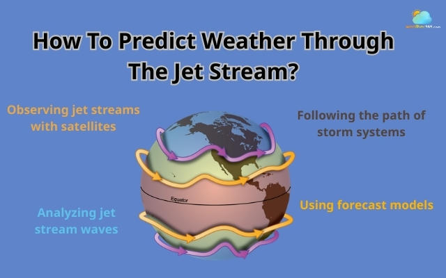
How Do We Predict Weather Through The Jet Stream?
Meteorologists closely monitor the jet stream because it helps determine how weather systems move.
Since storms and air masses often follow its path, tracking the jet stream allows forecasters to predict upcoming weather changes.
Observing jet streams with satellites
Weather satellites are one of the main tools used to track jet streams. They detect temperature patterns, cloud movement, and water vapor in the upper atmosphere.
These observations help scientists identify where jet streams are located and how they are shifting over time.
Following the path of storm systems
Storms usually travel along the path of the jet stream, moving from west to east.
By analyzing its position and direction, meteorologists can estimate where storms may develop, which areas might receive rain or snow, and when temperature changes are likely to occur.
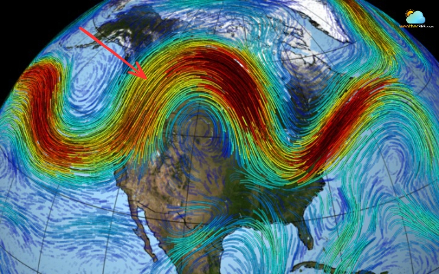
Analyzing jet stream waves
Jet streams often form large wave patterns in the atmosphere.
When the jet stream bends northward, it usually brings warmer and calmer weather.
When it dips southward, it can carry colder air and increase storm activity.
Using forecast models
Scientists also use computer weather models that combine data from satellites, weather balloons, and radar systems.
These models simulate how the jet stream may move in the coming days, helping meteorologists predict storm tracks, temperature shifts, and major weather patterns more accurately.
Detect the weather patterns by the jet stream
Final Thought
What is a jet stream? Think of it as a powerful river of wind flowing high above the Earth, quietly shaping the weather we experience every day. Once you understand how jet streams move and influence storms, temperatures, and even flights, weather forecasts start to make a lot more sense.
Frequently Asked Questions (FAQs)
Related post

Beaufort Wind Scale Chart: Discover Wind Speed Levels and How To Read Them

How To Measure Wind Speed: Step-by-Step Guide for Accurate Measurement

0 Comment
Leave a comment
Your email address will not be published. Required fields are marked *