




Super El Nino Builds as U.S. Faces a Wetter, Stormier Winter


A ‘Super El Nino’ is strengthening in the tropical Pacific and could shape a wetter, stormier U.S. winter in 2026-27. Forecasters are watching the potential for an exceptionally strong event, with California and parts of the South facing heightened risks of heavy rain, flooding and coastal impacts as winter approaches.
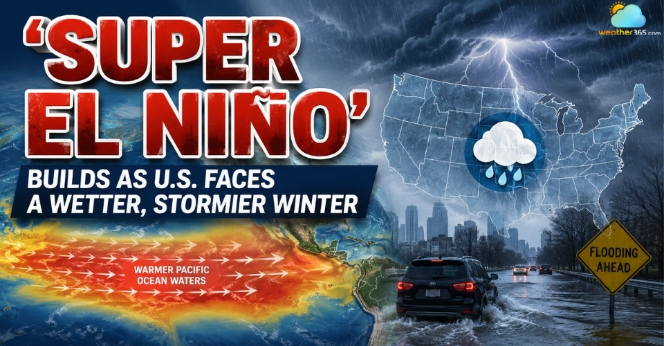
‘Super El Nino’ is forecasted to strengthen in the tropical Pacific
'Super El Nino' Strengthens Ahead of Winter 2026-27
'Super El Nino' is gaining strength across the tropical Pacific as forecasters look ahead to the 2026-27 winter season.
According to the National Oceanic and Atmospheric Administration (NOAA), El Nino strengthened over the past month, with sea surface temperatures more than 1°C above average across parts of the central and eastern equatorial Pacific.
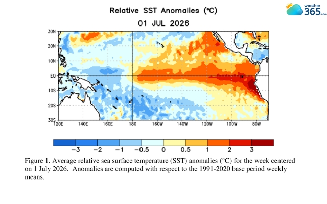
Average relative sea surface temperature on 1 July 2026
Source: NOAA Climate.gov
NOAA’s latest outlook gives a 97% chance that El Nino will persist through early spring 2027, while forecasting continued strengthening through the end of 2026.
The World Meteorological Organization (WMO) likewise reported on July 31 that El Nino is expected to strengthen during August-October 2026.
Besides, NOAA estimates an 81% probability of a powerful El Nino developing between October and December.
The shift is already evident in both oceanic and atmospheric conditions.
NOAA reported a latest weekly Nino-3.4 index of +1.2°C, alongside warming below the surface of the equatorial Pacific and changes in winds and convection that are consistent with a strengthening El Nino pattern.
For now, forecasters are focused on how the event evolves through late 2026.
NOAA’s next ENSO Diagnostic Discussion is scheduled for August 13, 2026, when updated observations and model guidance will provide a clearer picture of the developing winter pattern.
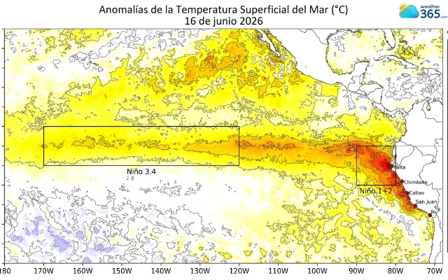
Sea surface temperatures across the tropical Pacific are running above average as El Nino strengthens ahead of winter 2026–27.
Wet and Stormy Winter Could Raise Flood Risks Across the U.S.
The developing El Nino is expected to reshape winter weather patterns across the United States, with wetter conditions favored across much of the West and southern tier.
According to the NOAA Climate Prediction Center (CPC), wetter-than-normal conditions are favored across much of the West, including Southern California and the Desert Southwest.
Much of the southern U.S. is also expected to see above-average precipitation.
That pattern could set the stage for a more active winter storm season in some parts of the country.
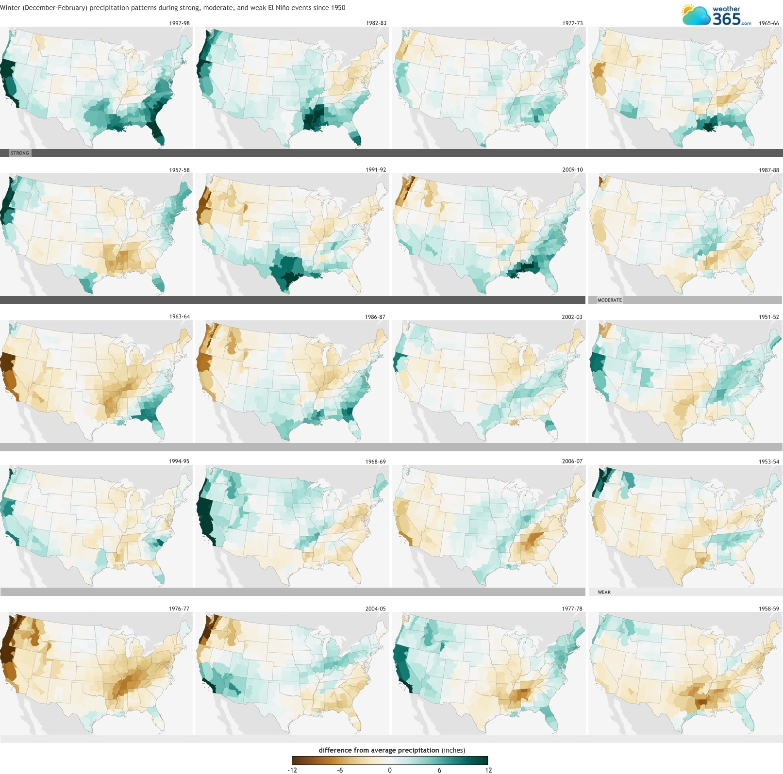
Winter precipitation pattern in the US during El Nino events since 1950
Source: NOAA Climate.gov
El Nino typically strengthens the subtropical jet stream and shifts the main storm track farther south, favoring more active weather across the southern U.S.
NOAA notes that El Nino winters are generally associated with greater storminess across the South, while northern areas tend to experience milder and less stormy conditions.
The resulting winter weather could vary considerably by location.
Some areas may see periods of heavy rain, while others could experience snow, mixed precipitation, freezing rain or other winter weather types as individual storms move across the country.
The exact balance between rain and snow will depend on local temperatures and the position of each storm.
For communities already vulnerable to heavy precipitation, repeated storms could increase the potential for flooding and other weather-related disruptions.
However, a seasonal El Nino outlook does not predict individual storms months in advance. The timing, intensity and track of specific systems will only become clearer as winter approaches.
California Faces Heightened Flood and Coastal Risks
California could face a particularly wet and hazardous winter as the strengthening El Nino raises the odds of heavy precipitation across the state.
According to the National Oceanic and Atmospheric Administration (NOAA), El Nino typically tilts precipitation odds toward wetter-than-normal conditions across Southern California.
Meanwhile, the California Geological Survey notes that El Nino can alter storm tracks and increase the frequency and characteristics of storms affecting the state.
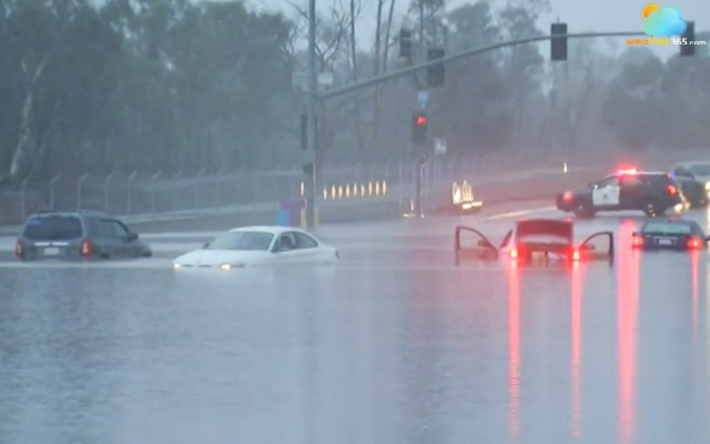
The second day of 2016 El Nino storms caused floods and mudslides in Southern California
Source: NBC News
The latest forecasts are drawing particular attention to the coast.
The Guardian reported that climate scientists estimate a 70% to 100% chance of above-average winter rainfall in California, raising concerns that repeated storms could overwhelm drainage systems, rivers and vulnerable communities.
Coastal flooding could become an additional concern when heavy storms coincide with high tides and large waves.
The California Coastal Commission says El Nino can temporarily raise sea levels along the coast as warm Pacific water expands, while storm surge, waves and high tides can compound the risk.
Low-lying coastal areas are therefore especially vulnerable during major winter storms.
What causes floods in California will vary by location, but intense rainfall over a short period, saturated ground, overflowing waterways and coastal water levels can all contribute.
Residents in flood-prone areas should prepare for flooding before major storms arrive, including knowing evacuation routes, securing important belongings and following official warnings.
Flood safety tips
|
The risk is not limited to flooding alone.
Prolonged heavy rain can saturate hillsides and increase the potential for landslides, particularly in areas affected by wildfire or previous vegetation loss.
California officials note that El Nino-related changes in rainfall can increase landslide impacts when storms bring sustained precipitation.
An Exceptionally Strong El Nino Could Rival Historic Events
The developing El Nino is showing signs of becoming unusually strong, prompting comparisons with some of the most notable El Nino events on record.
According to the World Meteorological Organization (WMO), its July-September 2026 outlook projected a seasonal-average Nino 3.4 temperature anomaly of around 2.0°C, with the warming trend expected to continue through the Northern Hemisphere autumn.
The latest NOAA Climate Prediction Center outlook also points to continued strengthening through the end of 2026.
NOAA says the event could reach a very strong intensity, although the agency's official ENSO classification does not use “Super El Nino” as a formal category.
The scale of the warming has prompted comparisons with major past El Nino events, particularly 1982-83, 1997-98 and 2015-16.
These episodes produced exceptionally large ocean-temperature anomalies and significant disruptions to weather patterns around the world.
The 1982-83 and 1997-98 events are especially relevant when assessing potential U.S. impacts because both were associated with major precipitation extremes in parts of the country.
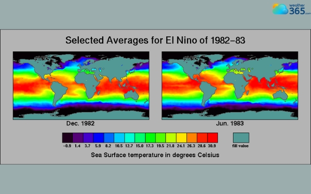
Ocean sea surface temperature averages El Nino 1982-1983
However, a strong El Nino does not automatically mean a repeat of any previous event. NOAA's historical records show that El Nino episodes can differ considerably in their location, timing and atmospheric response.
As a result, the eventual strength of the 2026-27 event and whether it ultimately ranks among the most powerful El Ninos on record will depend on how Pacific Ocean and atmospheric conditions evolve over the coming months.
References
NOAA Climate.Gov
The Guardian
Related post
Super El Nino 2026: NOAA Warns of Historic Record-Breaking Winter Impact
 212
212
 8
8
 4.8
4.8
 14/10/2026
Return of El Nino Could Trigger Record Heat and Climate Extremes
177
0
4.6
03/06/2026

0 Comment
Leave a comment
Your email address will not be published. Required fields are marked *