Is a super El Nino coming in 2026? Here's what we could expect
Climate experts warn that a rare and powerful El Niño event, often referred to as a “Super El Nino”, may develop in the coming months. These intense events are uncommon, with only about five recorded since 1950, the most recent occurring between 2015 and 2016.

The rare phenomenon Super El Nino
While scientists have not confirmed whether El Niño will definitely form this year, the probability is rising. According to the National Oceanic and Atmospheric Administration, as of April 9, there is a 61% chance that El Niño conditions will emerge, including roughly a 25% likelihood that it will become a strong event.
What is a super El Nino?
El Niño and La Niña refer to the warm and cool phases of a natural climate pattern in the tropical Pacific Ocean. El Niño is associated with unusually warm sea surface temperatures, while La Niña represents cooler-than-average conditions.
These events typically develop every two to seven years and can last from about nine months to several years.
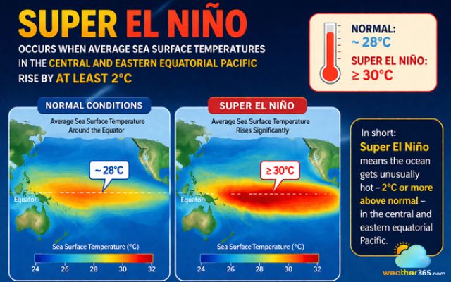
A strong El Niño, often called a “super El Niño,” occurs when average sea surface temperatures in the central and eastern equatorial Pacific rise by at least 2°C.
According to Paul Roundy (professor of atmospheric sciences at the University of Albany), this happens when warm water that has accumulated in the western Pacific shifts eastward, replacing the normally cooler waters.
In a super El Niño event, this warm water can significantly diminish the usual cold zone, causing temperatures in the eastern Pacific to rise by 2–3°C above normal—much higher than the increase seen in weaker events.
How does a super El Nino form?
How does a super El Nino impact?
The impacts of El Niño vary widely across the globe, according to Paul Roundy. Regions that typically receive little rainfall may experience unusually heavy precipitation, while areas that are usually wet can turn significantly drier.
During a strong El Niño year:
The Atlantic hurricane season is often less active, but storm activity in the Central Pacific may increase.
In South Asia, the summer monsoon can weaken, while parts of the Amazon and Australia may face drought conditions later in the year.
In the United States, southern regions often see cooler, wetter weather, whereas northern areas tend to be warmer than average.
El Niño can also raise concerns about global food security. Although advances in agriculture and transportation have improved resilience, shifting rainfall patterns still pose risks. As Roundy notes, reduced rainfall in typically wet regions can lead to crop failures in certain parts of the world.
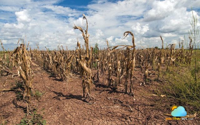
Super El Nino can raise concerns about food security
When was the last El Nino?
Believe it or not, over the past decade, the El Niño–Southern Oscillation (ENSO) has been dominated mostly by La Niña or neutral conditions.
Since 2017, a brief El Niño developed during the winter of 2018, followed by neutral conditions that lasted until spring 2020, when La Niña returned.
This La Niña phase persisted through the winter of 2023 before shifting back to neutral. Another El Niño emerged in the summer of 2023 and continued into late winter 2024, bringing above-average temperatures to the Midwest and wetter conditions across the Plains.
Since then, the system has largely trended back toward La Niña.
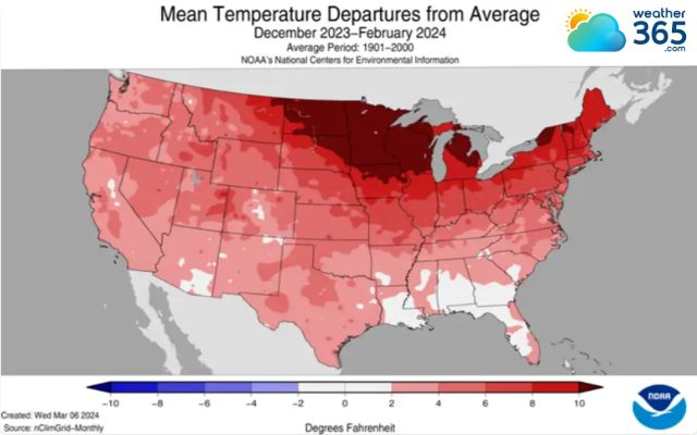
Temperature from Dec 2023 - Jan 2024 compared to 1901-2000 ( Source: NOAA)
Current climate models strongly suggest that El Niño is likely to develop again, although its strength and duration remain uncertain.
Related post

What Is The Highest Recorded Temperature In The World? Shocking Event Revealed

0 Comment
Leave a comment
Your email address will not be published. Required fields are marked *