Common Winter Weather Types: Definitions, Examples, and Impacts
Winter storms create many potential risks and have significant impacts on our daily lives. Apart from winter storms, there are several winter weather types. This post will dive into different types, formation, and their influences.
For a full overview of winter storm hazards, warnings, and safety tips, read our Winter storm guide.
Explore winter weather types
Winter weather types: Winter Storms
According to NOAA, a winter storm is a weather event that brings a combination of snow, sleet, freezing rain, or strong winds.
If you want a deeper breakdown of winter storm components, types, and safety, see Winter storm.
Winter storms are divided into 4 common types, and all of them lead to many life-threatening issues.
Blizzards
Blizzard is a severe type of winter storm. It is a combination of strong winds and blowing snow that leads to very low visibility.
While heavy snowfall often occurs, it's the wind and visibility, not the amount of new snow, that officially define a blizzard.
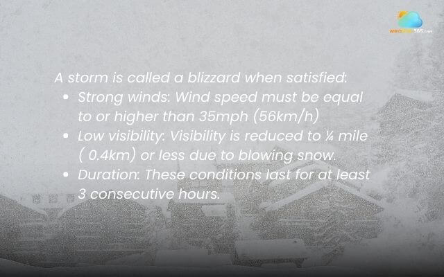
There are 3 specific criteria to determine whether a storm is a blizzard or not:
Strong winds: Wind speed must be equal to or higher than 35mph (56km/h)
Low visibility: Visibility is reduced to ¼ mile ( 0.4km) or less due to blowing snow.
Duration: These conditions last for at least 3 consecutive hours.
People often confuse these terms—see difference between a snowstorm and a blizzard for a clearer comparison.
Criteria for a blizzard
Blizzards are among the most dangerous winter storms, combining low visibility, extreme cold, and powerful winds.
They can leave people disoriented or stranded, while wind chills may trigger hypothermia and frostbite within minutes.
In addition, blizzard-force winds create massive snowdrifts that block roads, shut down travel, and even trap residents inside their homes, making these storms both life-threatening and highly disruptive.
Nor’easter
A Nor’easter is a powerful coastal winter storm that develops along the U.S. East Coast, named for the strong northeast winds that blow inland from the Atlantic.
These storms can bring heavy snow, strong winds, and coastal flooding—and in some cases, they produce blizzard-like conditions inland when wind and snowfall combine.
For a complete breakdown of how nor’easters form, where they hit, and how to stay safe, read What Is a Nor’easter?
If you’re wondering how this system compares to a tropical cyclone, see What’s the difference between a nor’easter and a hurricane?
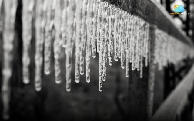
Ice storm
An ice storm is a significant accumulation of freezing rain. It's a particularly dangerous and damaging weather event because of how the ice builds up on surfaces.
The formation of an ice storm is a complex process involving multiple layers of air with different temperatures. It typically requires a specific atmospheric profile.
Precipitation begins high in the atmosphere as snow.
The snowflakes fall through a layer of warm air, where the temperature is above freezing. They melt completely and turn into liquid raindrops.
The rain then falls into a shallow layer of cold air (at or below freezing) just above the ground. The raindrops become supercooled, meaning they cool to a temperature below freezing but do not have time to freeze into solid ice pellets before they hit the ground.
The supercooled raindrops strike a surface such as trees, power lines, cars, or roads that is also below freezing, and they instantly freeze on contact.
An ice storm formation
An ice storm is a major threat due to the extreme weight of ice accumulation. The primary dangers include widespread power outages from downed lines and poles, and highly hazardous travel conditions as roads become coated in slick "glaze" ice.
Additionally, the immense weight can cause extensive property damage, particularly to trees that snap and fall on homes and cars, making it a serious safety concern for communities.
Lake effect storms
Lake effect storms, or commonly called lake effect snow, are highly localized winter weather events that occur on the downwind side of large, unfrozen bodies of water.
These storms are not caused by large-scale weather systems, but rather by the unique interaction between a cold air mass and the warmer lake water.
The formation of lake effect storms can be broken down into these key steps:
Cold Air Meets Warm Water: A very cold air mass, typically from the Arctic, moves over the warmer, unfrozen surface of a large lake.
Absorption of Moisture and Heat: As the air travels over the water, it warms up and absorbs a significant amount of moisture from the lake's evaporation.
Air Rises and Cools: The now warmer, moisture-laden air, which is less dense than the surrounding cold air, begins to rise.
Condensation and Cloud Formation: As the air ascends, it cools. This cooling process causes the water vapor to condense and form clouds.
Intense Snowfall: These clouds create narrow, intense bands of snow that are then deposited on the downwind (leeward) side of the lake as the air flows back over land.
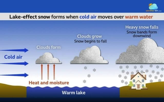
The lake effect snow formation
Lake effect storms are most common in the Great Lakes region of North America, but can occur downwind of any large body of water that remains unfrozen in the winter.
Lake effect storms are dangerous due to their intense, localized snowfall, which can cause "whiteout" conditions and make roads impassable.
The rapid accumulation poses a serious risk of accidents and can lead to communities being cut off.
Additionally, the sheer weight of the snow can cause roofs to collapse and trigger widespread power outages by damaging power lines and other infrastructure.
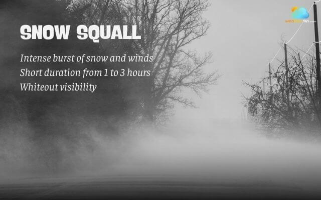
Snow squalls
A snow squall is a brief but intense burst of heavy snowfall and strong, gusty winds that dramatically reduce visibility and can create life-threatening travel conditions.
Learn more: What is a snow squall?
This winter weather type is best known in the Great Lakes region.
What are snow squalls?
Snow squalls form from a specific type of weather instability, often associated with a strong cold front. The formation happens when:
Intrusion of Cold Air: A fast-moving, very cold air mass moves over a relatively warmer surface. This could be the ground or, in the case of lake-effect snow squalls, a large unfrozen body of water.
Atmospheric Instability: The contrast between the cold air above and the warmer air below creates atmospheric instability. This causes the warmer, moist air to rise rapidly.
Convective Snow Showers: As the rising air cools, its water vapor condenses and freezes into heavy snow. This creates a narrow line of intense, convective snow showers.
Strong, Gusty Winds: Strong winds high in the atmosphere can be brought down to the surface by the descending cold air, creating powerful gusts that accompany the snowfall.
Snow squalls pose extreme danger due to their sudden onset and rapid change in conditions. They cause immediate and severe "whiteout" conditions, dropping visibility to near zero in seconds, which can disorient drivers and lead to multi-vehicle pileups.
Winter weather types: Winter Precipitation
Another winter weather type is winter precipitation. Depending on the temperature both in the atmosphere and at ground level, precipitation may fall as snow, sleet, or freezing rain.
Snow
Most winter precipitation begins as snow, since the upper layers of storm clouds are usually cold enough to form ice crystals. These crystals stick together to create snowflakes, which continue falling as snow when temperatures stay below 0°C (32°F) from cloud to ground.
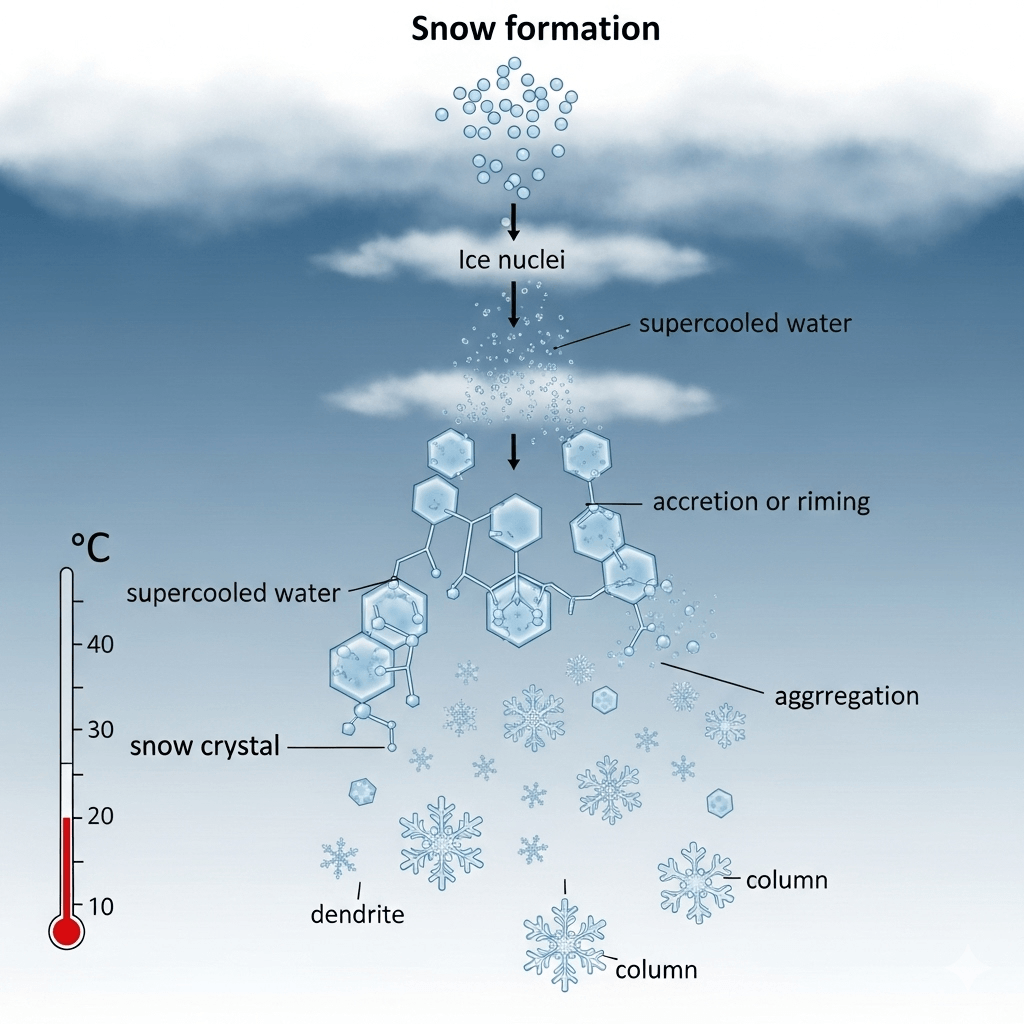
The process of snow formation
Snow can appear in different forms:
Snow flurries: Light, short-lived snow with little or no accumulation.
Snow showers: Brief bursts of snow with varying intensity and possible accumulation.
Snow squalls: Sudden, intense snow with strong winds, often causing dangerous whiteouts, especially near the Great Lakes.
Blowing snow: Wind-driven snow that reduces visibility and creates deep drifts, either from falling snow or snow lifted off the ground.
Blizzards: Severe storms with winds over 35 mph and heavy snow or blowing snow, reducing visibility to less than 1/4 mile for at least three hours.
These different types of snowfall highlight how winter weather can range from light flurries to life-threatening blizzards.
You may also encounter snow pellets (soft hail)—see What is graupel?
Sleet
Sleet is a form of winter precipitation consisting of ice pellets. It is often confused with freezing rain or a mix of rain and snow, but its formation process is distinct.
Sleet forms when the layer of the atmosphere's temperature is just right, creating a specific profile:
Snow Starts to Fall: Precipitation begins as snow high in the atmosphere, where temperatures are below freezing.
Melts in a Warm Layer: The snowflakes fall into a thin layer of warmer air (above freezing) and melt into raindrops.
Refreezes in a Cold Layer: Before reaching the ground, the raindrops fall through a deep, cold layer of air (at or below freezing). This cold layer is thick enough to cause the raindrops to refreeze into tiny, solid ice pellets.
When sleet hits the ground, it makes a distinctive "tinkling" or rattling sound and bounces off surfaces. This contrasts freezing rain, which is supercooled liquid that freezes on contact, creating a glaze of ice.
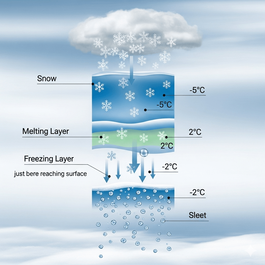
The sleet formation
Freezing rain
Freezing rain is a type of winter precipitation that begins as snow, melts into raindrops while passing through a warm air layer, and then falls into a shallow layer of freezing air near the ground.
The drops remain in liquid form but are supercooled, causing them to instantly freeze on contact with surfaces at or below 0°C (32°F).
Like sleet, freezing rain begins as snow high in a cold cloud. However, the atmospheric temperature profile is different.
Starts as Snow: Snowflakes fall from a cloud in a sub-freezing layer of air.
Melts in a Thick Warm Layer: The snowflakes fall into a deep layer of warm air (above freezing), causing them to melt completely into liquid raindrops.
Becomes Supercooled: The raindrops then fall into a very shallow, sub-freezing layer of air at the surface. This layer is not deep enough for the drops to refreeze into ice pellets. Instead, the drops become supercooled, remaining liquid even at temperatures below freezing.
Freezes on Impact: When these supercooled raindrops hit a surface at or below freezing (like roads, trees, or power lines), they freeze instantly upon impact, creating a smooth, hard layer of ice.
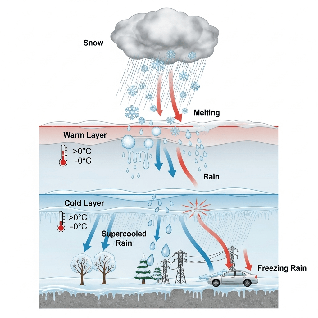
The freezing rain formation
The freezing rain creates a dangerous glaze of ice on roads, trees, power lines, and other objects. When freezing rain accumulates for several hours, it leads to an ice storm.
Other common winter weather types
Beyond the major winter weather systems, other common types can still create hazardous conditions. These include black ice, fog, and hoarfrost.
Frost and Hoar Frost
Frost and hoarfrost are both types of ice crystals that form on surfaces, but they are distinguished by the specific atmospheric conditions present during their formation.
👉 Frost is a thin layer of ice crystals that forms on surfaces like grass, windows, or cars when water vapor in the air freezes directly without becoming liquid first. It usually develops on clear, calm nights when temperatures drop below freezing and surfaces cool rapidly.
👉 Hoar frost is a more dramatic form of frost that appears as white, feathery ice crystals. It forms when there’s high humidity and very cold air, causing water vapor to deposit as intricate ice structures. Hoar frost often coats trees, fences, and other exposed surfaces, creating a sparkling, wintery landscape.
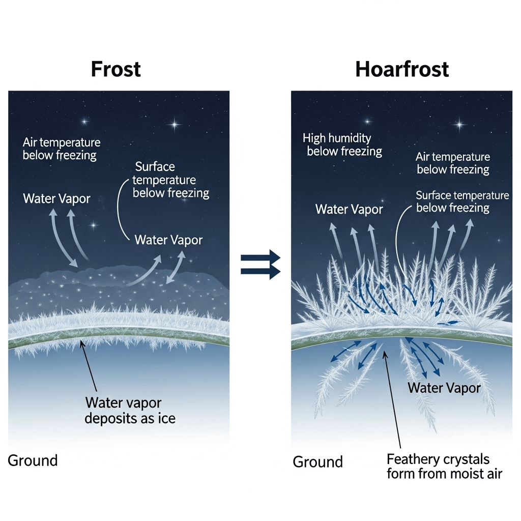
The frost and hoarfrost formation
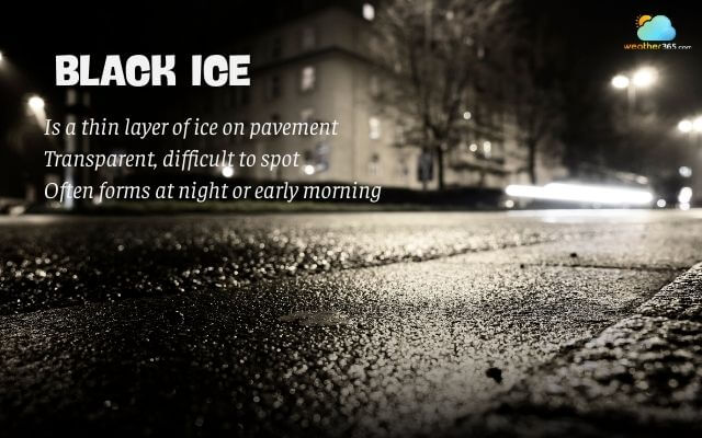
Black Ice
Black ice is a thin, nearly invisible layer of ice that forms on roads, sidewalks, and other surfaces when temperatures drop below freezing.
It gets its name because it is so transparent that it blends with the pavement, making it very hard for drivers and pedestrians to see.
Black ice often forms at night or early morning due to refreezing moisture, light rain, or melting snow.
Because of its slick, hidden nature, it is one of the most dangerous winter hazards, frequently causing accidents and falls.
What is black ice?
Fog
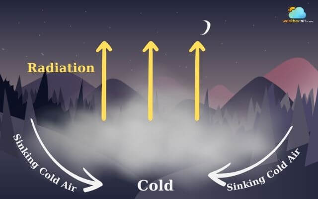
Fog is a weather phenomenon that occurs when tiny water droplets or ice crystals remain suspended in the air near the ground, reducing visibility to less than 1 kilometer (about 0.6 miles).
It forms when air becomes saturated with moisture and cools enough for condensation to occur, often during calm, humid conditions.
Fog is essentially a cloud at ground level and can vary in thickness, sometimes creating hazardous travel conditions by obscuring roads, runways, and coastlines.
The fog formation
There are several types of fog, categorized by the process that causes the condensation:
Radiation Fog: Forms on clear, calm nights when the ground rapidly cools, chilling the air directly above it to its dew point.
Advection Fog: Occurs when warm, moist air moves horizontally over a cooler surface, like a cold ocean current or snow-covered ground, causing the air to cool and condense.
Upslope Fog: Forms as moist air is forced up a mountain or hill, cooling as it rises and condensing into fog.
Freezing Fog: Consists of supercooled water droplets that freeze on contact with surfaces, creating a layer of ice.
Steam Fog: Forms when very cold air moves over a warmer body of water, causing water to evaporate and then immediately condense into fog.
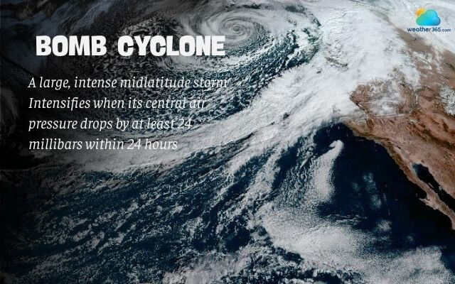
Bomb Cyclone
A bomb cyclone is a powerful winter storm that rapidly intensifies when its central air pressure drops by at least 24 millibars within 24 hours—a process known as bombogenesis.
This sudden strengthening creates very strong winds, heavy snow or rain, and blizzard-like conditions in colder regions.
Bomb cyclones often form along the U.S. East Coast or over the ocean, where cold Arctic air collides with warm, moist air, fueling explosive storm development.
Because of their intensity, bomb cyclones can cause dangerous travel conditions, coastal flooding, and widespread power outages.
For broader storm impacts and preparedness, see Winter storm.
What is a comb cyclone?
Conclusion
Understanding the different winter weather types is crucial for safety and winter storm preparedness. From the heavy snowfall of blizzards to the invisible dangers of black ice, each presents unique challenges. By recognizing how these weather events form and their potential impacts, communities and individuals can take the right precautions to minimize risks and better handle the extremes of winter.
For the complete winter storm checklist and safety guidance, read Winter storm. If you live on the U.S. East Coast, start with What is a Nor’easter?
0 Comment
Leave a comment
Your email address will not be published. Required fields are marked *