Spring Snowstorm Colorado: Heavy Snowfall, Temperature Drop
A spring snowstorm Colorado event swept into the region Tuesday evening, transforming earlier rain in the Denver metro area into bursts of heavy snow. At around 6 p.m., temperatures hovered near 34°F, which initially prevented accumulation on roadways, but conditions were expected to worsen overnight as colder air settled in.
Driving conditions deteriorated quickly, especially along the foothills, where slick roads caused major slowdowns. A jackknifed semi-truck on Interstate 70 near Evergreen Parkway added to traffic delays during the evening commute.
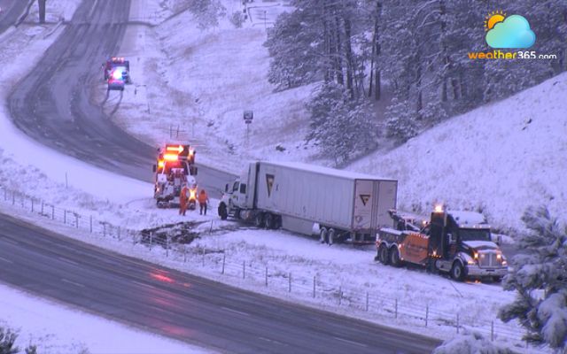
A jackknifed semi-truck on Interstate 70 near Evergreen Parkway
As the storm intensified, Denver Public Schools announced closures for Wednesday shortly before 7 p.m., followed by Aurora Public Schools and multiple districts across Colorado’s Front Range.
This spring snowstorm Colorado system also brought reduced visibility, with dense fog reported in areas like the Denver Tech Center and Castle Rock. Hazardous travel is expected to continue into Wednesday morning, with icy and slippery roads statewide.
At Denver International Airport, crews were actively de-icing aircraft Tuesday night, according to the FAA.
Before the snow began, Denver had already received over a quarter inch of rainfall. Forecasts indicate the city could see between 3 and 6 inches of snow before the system exits on Wednesday.
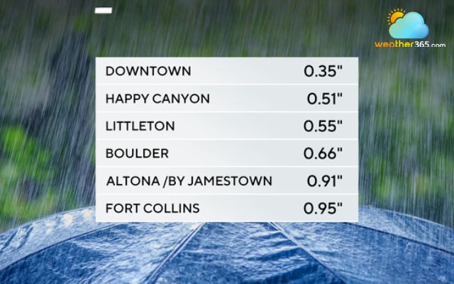
Rain forecast in the districts in Colorado
In Northern Colorado, Fort Collins recorded nearly an inch of rain prior to the changeover, prompting additional school closures due to expected heavy accumulation.
Snowfall totals are significantly higher in the mountains and foothills. Estes Park reported around 20 inches before nightfall, while Rabbit Ears Pass surpassed a foot, with more snow expected through Wednesday afternoon.
Following the storm, freeze watches and warnings are likely across much of the state.
Transportation officials noted that roads were not pre-treated due to unseasonably warm conditions leading up to the storm.
The Colorado Department of Transportation has deployed approximately 100 snowplows across the Denver area to manage the impact of this powerful spring snowstorm Colorado.
Driving in a snowstorm isn’t just uncomfortable—it can turn dangerous fast. Here are practical, no-nonsense tips to help you stay safe when conditions go bad:
|
Follow Weather365 to update the latest weather forecast across the US.
Related post

What is the difference between snowstorm and blizzard? Full explained

Worst snowstorm in U.S. history: Dates, Locations, and Record Impacts

Miami Grand Prix start time moved up due to thunderstorm risk, F1 confirm

0 Comment
Leave a comment
Your email address will not be published. Required fields are marked *