Massive Cold Front to Bring Severe Storms, Heavy Snow Across U.S
A massive cold front is set to push into the Northern Plains on Monday before advancing into the Midwest and sweeping across much of the country the week. This powerful system will bring a mix of severe thunderstorms, heavy rainfall leading to flooding, and snow in higher elevations.
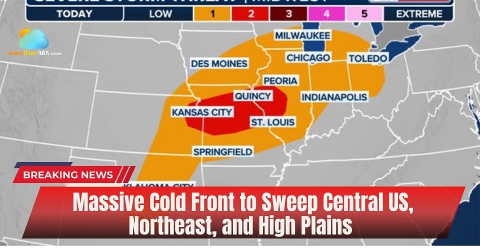
Massive cold front across the US
By late Monday, severe weather is expected to expand across the Midwest and Great Lakes, then shift into the Southern Plains and Deep South by midweek. At the same time, the northern portion of this massive cold front will deliver steady, heavy rain to the Northeast, while colder air wrapping around the system produces snowfall across the Northern Plains and the Rockies.
The widespread impact could also disrupt air travel across the central and eastern United States, including major hubs like Denver, as the system progresses.
In the wake of the front, temperatures are forecast to drop sharply—falling 20 to 30 degrees below seasonal averages. Many areas will experience conditions that feel more typical of early March rather than early May.
Severe weather alert in the Midwest
After a volatile April, a weather pattern is returning to the Midwest and South as a massive cold front drives multiple rounds of storms. Millions could face threats including damaging winds, large hail, tornadoes, and flash flooding, especially in areas like Missouri, Iowa, Illinois, Oklahoma, and Texas that were already hit hard last month.
More than 260 tornadoes have been reported across the central U.S. in the past month alone. On Monday, storms are expected to develop across the Upper Midwest, Ohio Valley, and Great Lakes as the massive cold front pushes south.

Damage when multiple rounds of storms go to the Midwest and South
The NOAA Storm Prediction Center has issued a Level 2 out of 5 severe weather risk for parts of Kansas, Missouri, and Illinois, with damaging winds and hail as the main concerns.
By Tuesday and Wednesday, the front is expected to stall over the Southern Plains and South, bringing continued storm chances to areas including Texas, Oklahoma, Arkansas, and later the Ark-La-Tex, Mississippi, and Alabama regions.
Heavy rain will also be a major concern from Kansas to Ohio, with the heaviest totals expected Tuesday into Wednesday. Slow-moving storms along the massive cold front could lead to localized flash flooding, especially from eastern Tennessee to southern Indiana.
Heavy rain in the Ohio Valley, Northeast
Heavy rainfall is forecast to spread from the Tennessee Valley into the Ohio Valley and Northeast starting Wednesday, tracking along the northern edge of the massive cold front.
This surge of downpours could disrupt travel, potentially causing delays at major airports along the busy Interstate 95 corridor in the Northeast.
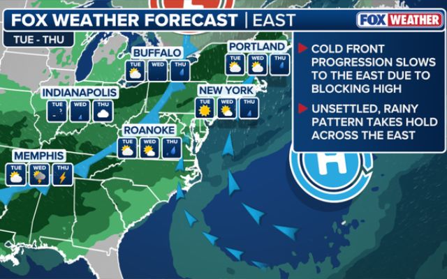
Heavy rain comes to the Northeast by mid-week
Snowstorm in the Rockies
In the wake of the massive cold front, a surge of colder air will bring heavy snowfall to the Central Rockies.
The FOX Forecast Center says the heaviest totals are expected in the mountains of Wyoming and Colorado, where higher peaks and mountain passes could receive 1 to 2 feet of dense, wet snow.
Across Colorado’s northern and central ranges—including areas like Breckenridge and Rocky Mountain National Park—snowfall totals of 8 to 12 inches are likely.
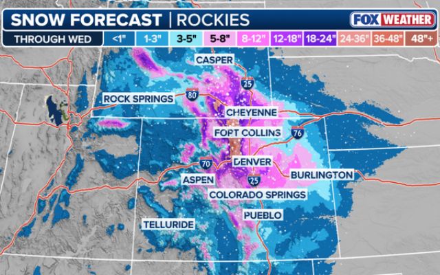
Snow forecast through the Rockies
A Winter Storm Warning remains in effect for Denver from Tuesday through Wednesday.
Snow is expected to taper off by Thursday, but much colder air will linger. Temperatures in Denver and across much of the eastern two-thirds of the country will feel more like early March than early May.
Follow Weather365 to update the latest weather forecast across the US.
Related post

Miami Grand Prix start time moved up due to thunderstorm risk, F1 confirm

Tornado in Texas: Severe Storm Outbreak Reaches Dangerous Peak

0 Comment
Leave a comment
Your email address will not be published. Required fields are marked *