Severe Weather Including Tornadoes Expected In Midwest South And Plains
It has been a prolonged stretch of dangerous conditions this week, and severe weather including tornadoes expected in Midwest South and Plains is set to continue. Additional rounds of storms are likely to impact many of the same areas already affected earlier. Forecasts indicate renewed threats of tornadoes, large hail, damaging winds, and flooding rain. By Friday, powerful thunderstorms are expected to develop across the Plains and Midwest, extending a multi-day pattern of severe weather that began earlier in the week.
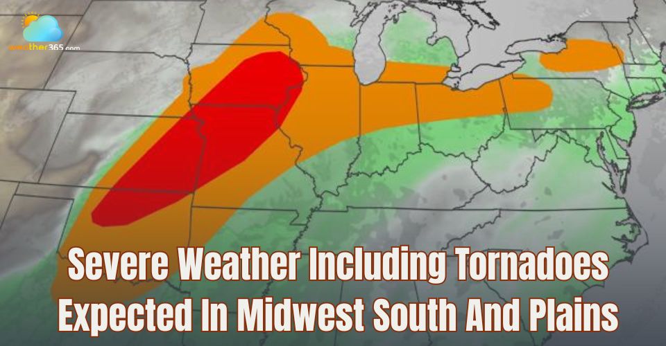
Severe weather in Midwest South and Plains
Current weather condition
Isolated to scattered thunderstorms, some potentially severe, may develop from the Northeast down to the mid-South and persist into the overnight hours, bringing risks of damaging wind gusts, hail, and a few possible tornadoes.
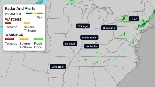
Happening now
Severe Weather Forecast
Friday
A more significant round of severe thunderstorms is expected on Friday, once again stretching from the Southern Plains to the upper Mississippi Valley.
The greatest concern includes the potential for strong tornadoes in eastern Iowa, northern Illinois, and southern Wisconsin during the late afternoon into early evening.
As the system evolves, one or more squall lines are likely to develop, bringing widespread damaging winds along with embedded tornadoes through the evening hours, particularly across the most at-risk areas.
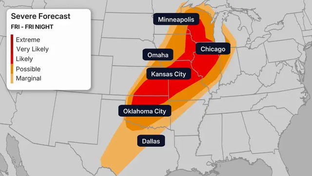
Severe forecast on Friday
The threat for damaging winds will be highest in northwestern Missouri, eastern Kansas, and southern Iowa. Storms could begin developing as early as midday and persist well into the night.
Saturday
On Saturday, a cold front will continue moving eastward, bringing a chance for isolated to scattered severe thunderstorms across the eastern Great Lakes and Ohio Valley.
However, this activity is expected to be less intense and less widespread compared to Friday.
Conditions are expected to improve afterward, with a relative lull in severe weather likely for at least a few days as the front pushes off the East Coast by Sunday.
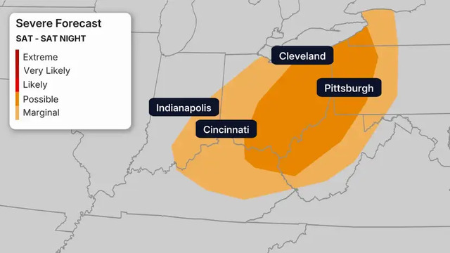
Severe forecast on Saturday
Flood alerts
Earlier rounds of heavy rain, combined in some areas with melting snow, have already led to significant flooding across parts of the western Great Lakes. Several rivers in Michigan and Wisconsin are currently at, or expected to reach, major flood stage.
Flood watches remain in effect across a broad area, including much of Michigan. Looking ahead, a corridor from eastern Kansas to the interior Northeast is forecast to receive more than an inch of additional rainfall through Saturday, impacting cities such as Kansas City, Chicago, and Syracuse.
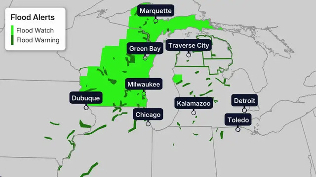
Flood alerts
Where repeated thunderstorms or storm clusters develop, rainfall totals could be even higher. This raises the risk of dangerous flash flooding, especially in urban locations and regions where the ground is already saturated.
Why the severe parade?
The setup is actually quite interesting. A high-pressure system over the eastern U.S. is helping push Gulf moisture northward across the Plains, creating an environment favorable for thunderstorms.
At the same time, dips in the jet stream, or troughs, are moving out of the West into the Central Plains. These troughs often act as triggers for severe weather.
With high pressure in the East and repeated troughs moving through the Plains, the same regions may face severe storms day after day.
Related post
")
Strong tornadoes very large hail could hit Minnesota on Monday ( Updated)

Is a super El Nino coming in 2026? Here's what we could expect

0 Comment
Leave a comment
Your email address will not be published. Required fields are marked *