Record Breaking Heat in the US Fueled by Powerful High-Pressure Ridge
A developing record breaking heat in the US is expected to bring widespread summer heat across much of the country in the coming days, with temperatures climbing into the 80s, 90s, and even exceeding 100°F in some regions.
Meteorologists are forecasting above-average temperatures across all 48 contiguous states between June 11 and June 17. According to weather experts, a prolonged period of intense heat combined with rising humidity could create dangerous conditions for millions of Americans as the month progresses.
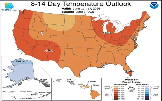
Above-normal temperatures are expected across48 states ( NOAA Climate Prediction Center)
High-Pressure Ridge Driving Extreme Heat
The primary driver behind this hot weather pattern is a large ridge of high pressure expected to strengthen over much of the nation. A ridge forms when atmospheric pressure increases, causing air to sink toward the surface.
As the air descends, it compresses and warms, creating clear skies, dry conditions, and significantly higher temperatures.
These weather systems are commonly associated with some of the most severe summer heat waves in North America.
The sinking air also prevents cloud formation and traps heat near the ground, allowing temperatures to build day after day. Because of these conditions, the ongoing record breaking heat in the US could persist for an extended period in several regions.
Severe summer heat waves in North America
East Coast Faces Elevated Heat Risks
The East Coast is expected to experience particularly notable heat impacts. Forecasters from the National Weather Service warn that elevated daytime temperatures, combined with unusually warm nights, may increase health risks for vulnerable populations.
Areas across the Mid-Atlantic could see moderate to major heat-related impacts, especially for residents lacking access to air conditioning or adequate hydration.
Warm overnight temperatures are especially concerning because they reduce the body's ability to recover from daytime heat stress.
Meteorologists note that the high June sun angle and widespread drought conditions across portions of the country may further intensify the heat.
Dry soils absorb and release heat more efficiently than moist ground, allowing temperatures to rise even higher in affected regions.
As a result, communities already experiencing drought could see temperatures exceed seasonal averages by a significant margin during the peak of the heat event.
Brief Relief Possible in Some Western States
While most of the nation is expected to remain warmer than normal, some temporary relief may arrive in parts of the western United States as a weather front moves through mid next week.
This system could briefly lower temperatures in parts of the West and eventually provide modest cooling across portions of the central United States. However, forecasters emphasize that the cooldown is likely to be short-lived.
Warm Pattern Could Last Through Mid-to-Late June
Temperatures are expected to rebound quickly, especially across California, the Pacific Northwest, and the Southwest, where significant warming is forecast later in the month.
Current outlooks suggest that the most persistent heat will occur across the western states, where high-pressure ridging may remain dominant well into late June.
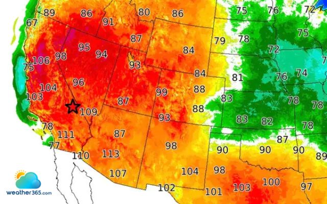
Heat wave across the western states
East of the Rocky Mountains, temperature fluctuations tied to passing weather systems are more likely, but an extended stretch of above-normal warmth is increasingly expected across portions of the eastern United States through at least mid-June.
As summer begins, residents nationwide are encouraged to monitor local forecasts, stay hydrated, and take precautions against heat-related illnesses as this potentially record breaking heat in the US continues to develop.
Related post

Early Spring Severe Weather Season Sees Reduced Tornado Deaths

Return of El Nino Could Trigger Record Heat and Climate Extremes

0 Comment
Leave a comment
Your email address will not be published. Required fields are marked *