




Hurricane Season Update: 2 Systems Being Monitored as Peak Season Nears


The 2026 hurricane season has been unusually quiet so far, but that could change as forecasters monitor new tropical systems in the Atlantic. With peak hurricane season approaching, several areas are now being watched for possible development. Here are the latest hurricane season threats and areas to watch.
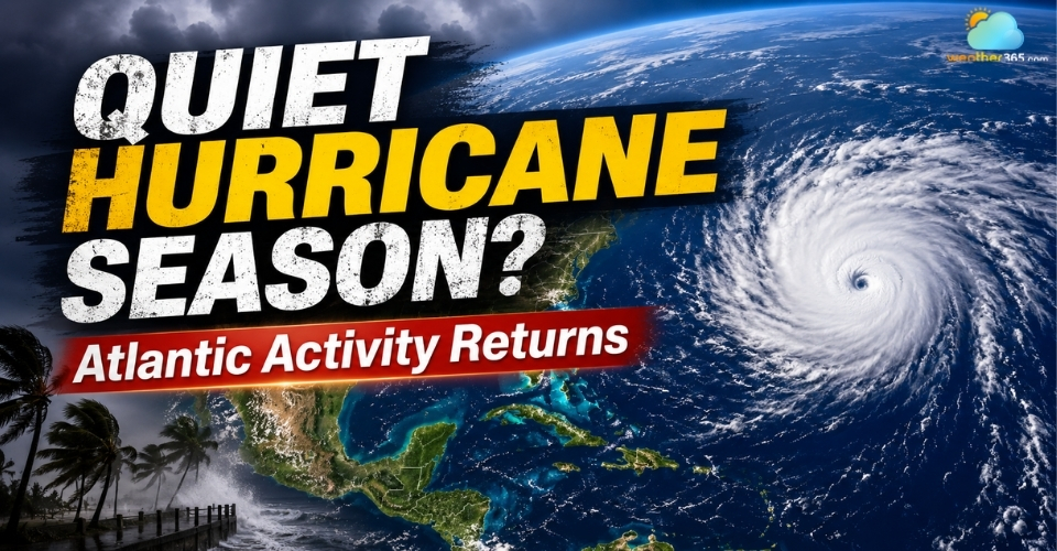
Peak hurricane season is approaching
- Hurricane Season Remains Quiet as Peak Activity Nears
- Two Atlantic Systems Are Being Monitored
- Invest 95L
- Tropical Wave Near Africa (Invest 96-L)
- Which Areas Could See Impacts?
- Bermuda
- Caribbean
- Florida and the U.S. East Coast
- Pacific and Hawaii
- Why Has the 2026 Hurricane Season Been So Quiet?
- NOAA's Latest 2026 Forecast
Hurricane Season Remains Quiet as Peak Activity Nears
The 2026 Atlantic hurricane season has remained unusually quiet since it began June 1, with only limited tropical activity so far.
The slow pace stands out as the basin approaches the busiest part of the season, when tropical systems typically become more frequent.
The Atlantic hurricane season runs through November 30, but activity usually increases from August into early fall, with September 10 marking the climatological peak.
(Read more: When is hurricane season?)
So far, the quiet pattern has continued despite the approach of peak season.
Recent reports describe 2026 as the quietest start to an Atlantic hurricane season this century, with only three named storms recorded so far.
However, the lack of activity does not mean the Atlantic will remain quiet through the rest of the season.
Forecasters are now watching for signs that tropical activity could begin to increase as peak season approaches.
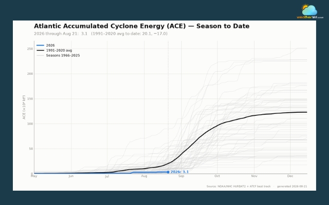
Quietest start to an Atlantic hurricane season this century
Source: NOAA
Two Atlantic Systems Are Being Monitored
The Atlantic is showing signs of renewed activity, with the National Hurricane Center monitoring two areas for possible tropical development.
One is Invest 95L, a low-pressure system southeast of Bermuda. The other is Invest 96L - a tropical wave emerging from Africa.
Invest 95L
Invest 95L was located several hundred miles southeast of Bermuda on Monday.
The system had a 50% chance of developing into a tropical depression or tropical storm over the next seven days, according to the National Hurricane Center.
The low has become somewhat better organized, but conditions remain only marginally favorable for further development.
Forecasters expect it to turn north and then northeast over the open Atlantic.
It could briefly strengthen into a tropical depression or storm before moving over colder water and weakening.
For now, the system is expected to remain well away from the U.S. East Coast, the Caribbean and the Gulf of Mexico. Its main area of interest is the open Atlantic near Bermuda.
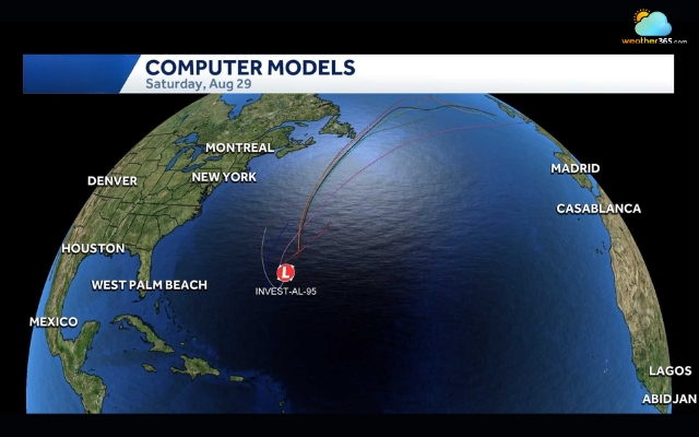
Invest 95-L had a 50% chance of developing into a tropical depression or tropical storm
Source: WPBF 25 News
Tropical Wave Near Africa (Invest 96-L)
A second system is emerging from the west coast of Africa.
The wave had a low chance of development in the short term, but its odds increased to about 50% over seven days in the latest outlook.
The wave is expected to move westward across the tropical Atlantic. Forecasters say it could become a tropical depression later this week if it becomes better organized.
However, it remains far from land, and its eventual track is still uncertain.
Neither system is currently a named tropical storm.
Forecasters will be watching for changes in organization, strength and track as both disturbances move across the Atlantic.
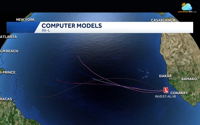
Invest 96-L had a low chance of development in the short term
Source: WPBF 25 News
Which Areas Could See Impacts?
For now, the potential impacts are limited, with Bermuda and the northeastern Caribbean the areas to watch most closely.
The current forecast does not point to a direct threat to Florida or the U.S. mainland, but conditions could change as the systems develop.
Bermuda
Invest 95L is the system closest to Bermuda. It is located southeast of the island and is forecast to move north or northeast over the open Atlantic.
The system could bring rain, gusty winds and rough seas if it passes close enough to Bermuda.
However, current forecasts keep the center well offshore, so a direct hit is not expected at this time.
Caribbean
The northeastern Caribbean is worth watching as the tropical wave near Africa moves westward. If the wave becomes better organized, it could eventually move closer to the islands.
Forecasters have not yet identified a specific track or threat to any particular island, making the situation too uncertain for a detailed impact forecast.
Florida and the U.S. East Coast
Florida is not currently facing a clear tropical threat. Invest 95L is expected to turn north and northeast while remaining over the Atlantic, rather than moving toward the U.S. coast.
Current forecasts also show no direct threat to the U.S. East Coast or Gulf of Mexico from the system.
The second system is farther east and remains too early to determine whether it could eventually approach the United States.
Its westward movement means forecasters will continue to monitor it as new forecast data becomes available.
Read more: How many hurricanes hit Florida?
Pacific and Hawaii
The Atlantic is the main focus, but tropical activity is also being monitored in the Pacific.
Any potential impacts to Hawaii would depend on the development and track of individual systems, so there is no need to suggest a specific threat without supporting forecasts.
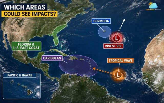
Forecast areas to be impacted by 2026 hurricane season
Why Has the 2026 Hurricane Season Been So Quiet?
According to NOAA, a strengthening El Nino is a major reason behind the Atlantic’s slow start.
El Nino increases vertical wind shear across the Atlantic, which can disrupt thunderstorms and make it harder for tropical systems to organize and strengthen.
NOAA expects El Nino to continue strengthening through the peak months of the season.
Saharan dust has also added to the unfavorable conditions.
Dry, dusty air from North Africa can limit thunderstorm activity and make the environment less supportive of tropical development.
Still, a quiet season does not mean the threat is gone.
As ocean and atmospheric conditions change through August and September, tropical activity can increase quickly.
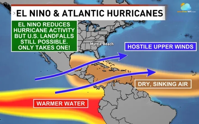
El Nino reduces hurricane activity
Relate articles
NOAA's Latest 2026 Forecast
NOAA’s August 6 update continues to favor a below-normal Atlantic hurricane season.
Forecasters give the season a 75% chance of being below normal, compared with 20% for near-normal activity and 5% for above-normal activity.
Metric | NOAA 2026 Forecast |
Named storms | 7–13 |
Hurricanes | 2–6 |
Major hurricanes | 0–2 |
Chance of below-normal season | 75% |
References
USA Today
WPBF
FOX Weather
AOL
Related post
What state gets the most hurricanes? Found Top 10 storm hotspots in the US
 410
410
 8
8
 4.9
4.9
 06/08/2026

Where Do Most Hurricanes Occur? Top ranking of countries and US States
281
9
4.8
27/08/2026

Difference Between Hurricane Watch and Warning: What You Need to Know
105
8
4.9
06/08/2026

0 Comment
Leave a comment
Your email address will not be published. Required fields are marked *