TOP 10 Largest Earthquakes In The World: Stats, Destruction & Aftermath
Have you ever wondered which were the largest earthquakes in the world and how they changed history? In this blog, we will uncover the top 10 most powerful quakes ever recorded, the devastation they caused, and the global trends that shape our understanding of earthquakes today.
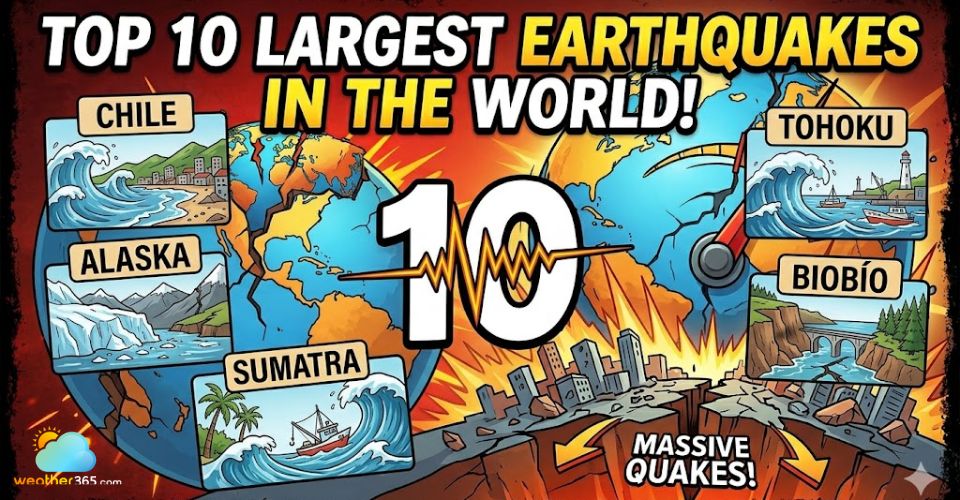
Largest earthquakes in the world
- Top 10 Largest earthquakes in the world
- 1. Biobio, Chile
- 2. Alaska USA
- 3. Sumatra, Indonesia
- 4. Tohoku, Japan
- 5. Kamchatka, Russia
- 6. Biobio, Chile
- 7. Esmeraldas, Ecuador
- 8. Alaska, USA
- 9. Arunachal Pradesh, India
- 10. Sumatra, Indonesia
- Deadliest earthquakes in the world
- Earthquakes Worldwide: Key Insights & Trends
- Distribution
- Impact
- Frequency
- Trends
Top 10 Largest earthquakes in the world
Throughout history, some earthquakes have stood out for their sheer power and lasting impact.
In this section, we explore the top 10 largest earthquakes in the world, looking at each earthquake magnitude scale, their causes, and the destruction they left behind.
1. Biobio, Chile
Time: 22 May 1960 (UTC 19:11)
Place: Biobío / Valdivia, Chile.
Magnitude: Mw 9.5.
On 22 May 1960, a megathrust rupture near Valdivia released the most energy ever measured by instruments, assigned Mw 9.5.

What is the largest earthquake in the world?
The quake happened where the Nazca Plate dives under the South American Plate.
Violent shaking lasted for minutes and triggered a tsunami that crossed the Pacific, striking Hawaii, Japan, and New Zealand.
Coastal towns were flattened, infrastructure collapsed, and estimates of lives lost run into the thousands; whole shorelines were changed, and rebuilding took years.
This event became the benchmark for modern tsunami science and early-warning research.
2. Alaska USA
Time: 27 March 1964 (local 17:36)
Place: Prince William Sound, Alaska, USA.
Magnitude: Mw 9.2
At 17:36 (local time) on 27 March 1964, the Good Friday earthquake began beneath Prince William Sound of Alaska, USA, and lasted about four to five minutes, with a moment magnitude of 9.2.
This is considered one of the largest earthquakes in the world.
It was a megathrust event caused by the Pacific Plate slipping under North America. Ground deformation, landslides, and powerful tsunamis struck local shores and remote Pacific coasts.

The devastating impact of Alaska’s Good Friday earthquake
Though Alaska’s population was sparse, the quake destroyed large parts of Anchorage and caused over one hundred fatalities; it also changed local topography and led to major advances in seismic building codes.
3. Sumatra, Indonesia
Time: 26 December 2004
Place: Off northern Sumatra, Indonesia
Magnitude: Mw 9.1.
On 26 December 2004, a massive thrust rupture along the Sunda megathrust produced an earthquake of about Mw 9.1-9.3.
The seafloor jump generated an enormous tsunami across the Indian Ocean.
Coastal communities from Aceh to Somalia were devastated; fatalities estimates exceed 200,000 people, and millions were displaced.
The disaster exposed gaps in regional warning systems and prompted global investment in tsunami detection. Today, knowing immediate earthquake safety tips and disaster preparedness is considered essential for coastal communities worldwide.
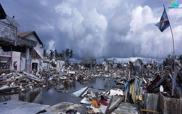
The Sumatra earthquake in 2004 spread over 14 countries
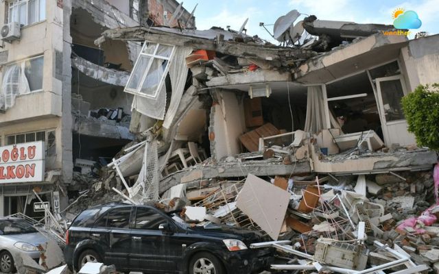
4. Tohoku, Japan
Time: 11 March 2011
Place: Off northeast Honshu, Japan
Magnitude: Mw 9.1.
On 11 March 2011, the Tōhoku earthquake was a shallow megathrust event east of Honshu with Mw 9.1.
The quake produced a fast, huge tsunami that overwhelmed coastal defenses and reached tens of meters in places.
More than 18,000 people lost or remain missing, and the tsunami caused catastrophic damage to towns, ports, and the Fukushima Daiichi nuclear plant.
The scale of destruction reshaped Japan’s disaster policy, building standards, and nuclear regulation.
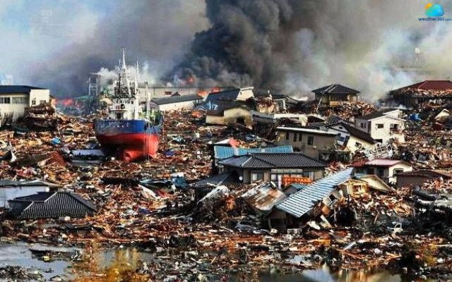
The aftermath of the Tohoku earthquake in 2011
5. Kamchatka, Russia
Time: 4-5 November 1952
Place: Off the east coast of the Kamchatka Peninsula, Russia
Magnitude: Mw 9.0
The 1952 Kamchatka (Severo-Kurilsk) earthquake stemmed from subduction along the Kuril-Kamchatka trench and is estimated near Mw 9.0.
The earthquake generated a large Pacific-wide tsunami that struck the Kuril Islands and the Russian coasts hard.
Local settlements were severely damaged, and many lives were lost in coastal communities.
The event is a reminder that high-magnitude oceanic quakes can produce deadly tsunamis even where population centers are limited.
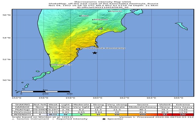
Estimated ground shaking of the Kamchatka earthquake in 1952
Source: Volcano Discovery
6. Biobio, Chile
Time: 27 February 2010.
Place: Offshore Maule / Biobío region, Chile.
Magnitude: Mw 8.8.
On 27 February 2010, a long rupture on the Nazca-South America plate boundary produced the 2010 Mw 8.8 quake off central Chile.
The event triggered strong shaking across a wide region, local tsunamis, and large coastal displacement.
Hundreds of people lost their lives, thousands were left homeless, and economic losses reached many billions of dollars.
The quake moved cities by meters and reinforced Chile’s focus on resilient infrastructure and rapid emergency response.
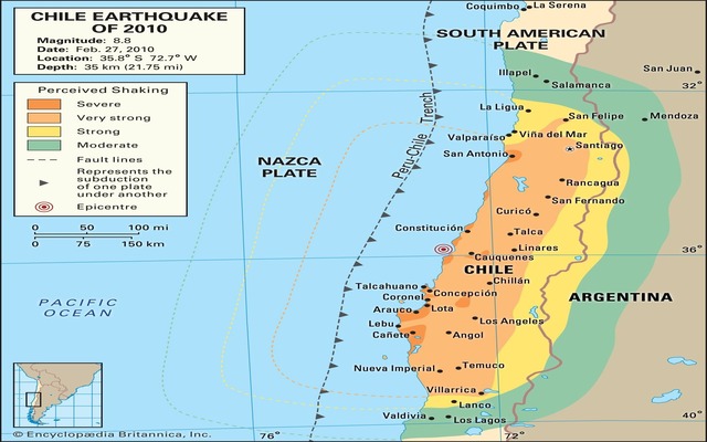
Map showing the shaking level during the Biobio earthquake in 2010
Source: Encyclopædia Britannica
7. Esmeraldas, Ecuador
Time: 31 January 1906
Place: Off Esmeraldas, Ecuador
Magnitude: Mw 8.8
The 1906 Esmeraldas (Ecuador-Colombia) earthquake occurred along a major subduction zone and is estimated at about Mw 8.8.
The earthquake created a destructive tsunami that ran up coastal villages and caused a large loss of life at a time when warning systems did not exist.
Because it predates modern seismographs, many details rely on historical records and geological reconstruction, but its impact helped shape later regional seismic studies.
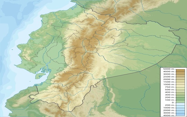
1906 Ecuador earthquake relief location map
Source: Wikipedia
8. Alaska, USA
Time: 4 February 1965 (UTC).
Place: Rat Islands, Aleutian Islands, Alaska.
Magnitude: Mw 8.7.
On 4 February 1965, the 1965 Rat Islands earthquake in Alaska was a megathrust event in the Aleutian subduction zone, measured at Mw 8.7.
It produced a tsunami that reached over ten meters on nearby islands but caused little damage to populated areas because the islands are sparsely inhabited.
The quake remains an important lesson for understanding how Aleutian subduction slips distribute energy and how remote tsunamis can still threaten wider regions.
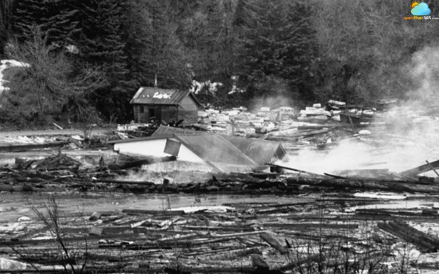
Great Alaska Earthquake of 1964
9. Arunachal Pradesh, India
Time: 15 August 1950.
Place: Mishmi Hills
Magnitude: Mw ~8.6.
The 1950 Assam-Tibet earthquake struck the Mishmi Hills and is among the largest earthquakes in the world on land, with Mw commonly cited near 8.6-8.7.
Unlike most entries on this list, this earthquake resulted from continental collision along the Himalayan thrust system rather than oceanic subduction.
The quake caused widespread landslides, buried villages, blocked rivers, and took the lives of thousands of people; its inland location amplified slope failures and local devastation.
The 1950 Assam-Tibet earthquake reached 8.7 magnitude
10. Sumatra, Indonesia
Time: 28 March 2005.
Place: Off the west coast of northern Sumatra (Nias, Simeulue).
Magnitude: Mw 8.6.
On 28 March 2005, the Nias-Simeulue earthquake occurred on the Sunda megathrust and measured about Mw 8.6.
The rupture produced strong local shaking and a modest tsunami that struck nearby islands, especially Nias, where many homes and public buildings collapsed.
Casualties numbered in the low thousands, and recovery required major reconstruction.

At least 915 people lost their lives in the Nias-Simeulue earthquake
Deadliest earthquakes in the world
The 1556 Shaanxi earthquake in China remains the deadliest earthquake ever recorded in human history. It struck on January 23, 1556, during the Ming Dynasty, with an estimated magnitude of 8.0.
The epicenter was located near Huaxian in Shaanxi Province, but the devastation stretched across a wide region, affecting more than 500 miles.
What made this earthquake especially catastrophic was not only its strength but also the living conditions of the population. At the time, many people lived in yaodongs, traditional cave dwellings carved into the soft loess soil.
When the quake hit, entire cliffs and hillsides collapsed, burying families instantly. This unique vulnerability turned the disaster into a human tragedy of immense scale.
Historical records estimate that over 830,000 people lost their lives, making it the most devastating in terms of human toll earthquake in history. Cities and villages were flattened, farmlands destroyed, and rivers altered by landslides.
Survivors described gaping cracks in the earth and mountains that suddenly shifted shape.
The causes of the earthquake are linked to the movement of faults in the Wei River Basin, a seismically active area due to tectonic stress between the Eurasian Plate and surrounding fault systems.
While the exact fault rupture cannot be fully traced with modern tools, the magnitude of destruction makes clear the immense seismic energy released.
Beyond the physical losses, the Shaanxi earthquake left deep cultural and social scars.
Records from scholars and officials reveal how people struggled to rebuild, how famine followed, and how fear of recurring quakes haunted the region for generations.
This disaster remains a stark reminder of how natural forces, combined with human vulnerability, can shape history.
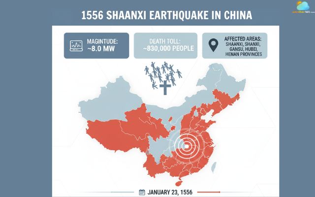
The 1556 Shaanxi Earthquake Statistic
Earthquakes Worldwide: Key Insights & Trends
Tracking earthquakes worldwide helps communities prepare for future disasters.
Now let’s examine the regions most at risk, the human and economic impacts, the frequency of significant events, and emerging trends in seismic activity.
Distribution
Earthquakes are not spread evenly across the planet. About 90% of the world’s earthquakes occur along the Pacific Ring of Fire, which stretches from Chile up to Alaska and across to Japan and New Zealand (USGS).
Another 5-6% happen in the Alpide Belt, which passes through southern Europe, the Middle East, and the Himalayas.
The rest occur in scattered intraplate regions. This uneven pattern is driven by tectonic plate boundaries, where stress builds and faults slip.
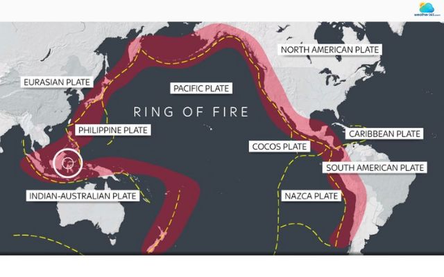
The “Ring of Fire” causes over 90% of the world's earthquakes
Impact
The effects of earthquakes vary widely depending on population density, building standards, and preparedness.
For example, the 2011 Tōhoku earthquake in Japan (M9.1) took the lives of about 20,000 people and caused $235 billion in damages - the costliest disaster in history (World Bank, 2012).
In contrast, the 1964 Alaska earthquake (M9.2) was stronger but only 131 people lost, largely because of lower population exposure.
According to EM-DAT, earthquakes caused 721,000 fatalities between 2000 and 2022, making them one of the deadliest natural hazards globally. For detailed information about earthquakes’ distribution and impacts, drop by our full guide on what causes an earthquake!
Economic losses are also staggering, often reaching tens of billions per event.
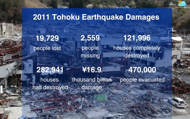
The 2011 Tōhoku Earthquake and Tsunami stands as one of the most devastating natural disasters in modern history
For detailed information about earthquakes’ distribution and impacts, drop by our full guide on what causes an earthquake!
Frequency
Seismic monitoring shows many thousands of quakes every year.
The United States Geological Survey (USGS) estimates there are roughly 500,000 detectable earthquakes annually, of which about 100,000 are felt. Most of these minor seismic activities represent the subtle difference between earthquake and tremor, where minor shakes occur often without causing any structural damage.
Modern catalogs routinely record ~20,000 earthquakes per year (those located and reported by global networks).
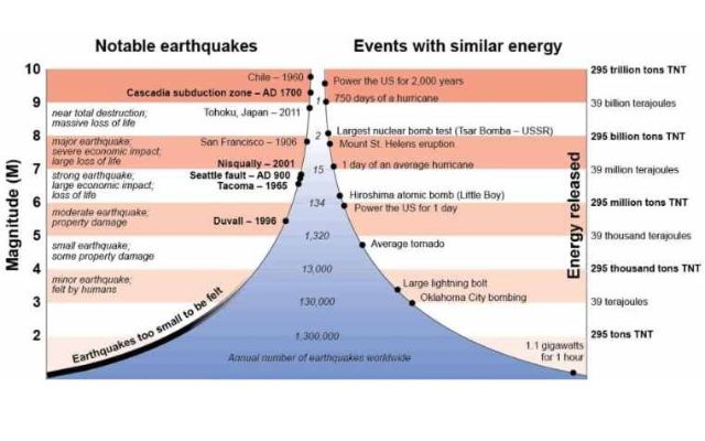
On average, the long-term record indicates about 15 magnitude-7 events and one magnitude-8+ event per year.
To better understand these occurrences, researchers also study the signs of earthquake, which can help in predicting and mitigating potential damage
Number of Earthquakes per year worldwide
Source: The Constructor
Trends
According to the US Geological Survey (USGS), the number of recorded earthquakes has grown significantly over the past century.
While the actual frequency of earthquakes may not have increased dramatically, the enhanced detection capabilities have led to more events being recorded.
For instance, between 2000 and 2021, the USGS recorded:
Magnitude 8.0 and above: Approximately 1 to 3 events per year.
Magnitude 7.0-7.9: Between 6 and 23 events per year.
Magnitude 6.0-6.9: Ranging from 104 to 185 events annually.
Magnitude 5.0-5.9: Between 1,312 and 2,276 events each year.
At the same time, the Emergency Events Database (EM-DAT) shows large natural-disaster impacts remain high: In 2022, natural hazards caused 30,704 reported fatalities and some US$223.8 billion in damage (all hazards combined).
Earthquakes still account for a large share of disaster fatalities globally. Economic studies also show that single major quakes can cause tens to hundreds of billions of dollars in losses.
Reducing future tolls depends on stronger buildings, land-use planning, and early-warning systems - not on changing the planet’s seismicity.
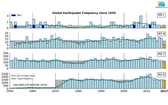
Global earthquake frequency from 1950-2017
Conclusion
Discovering the largest earthquakes in the world helps us understand the risks we continue to face. Each disaster leaves lessons about preparation, response, and recovery. By applying this knowledge, we can reduce damage and save lives in the future. To stay updated on seismic threats, monitor active fault lines, or check global storm developments in real-time, visit our Live Weather Radar.
Frequently Asked Questions (FAQs)
Related post

Earthquake Magnitude Scale: Different Methods of Measuring Earthquakes

Difference Between Earthquake and Tremor: How To Distinguish Them?

0 Comment
Leave a comment
Your email address will not be published. Required fields are marked *