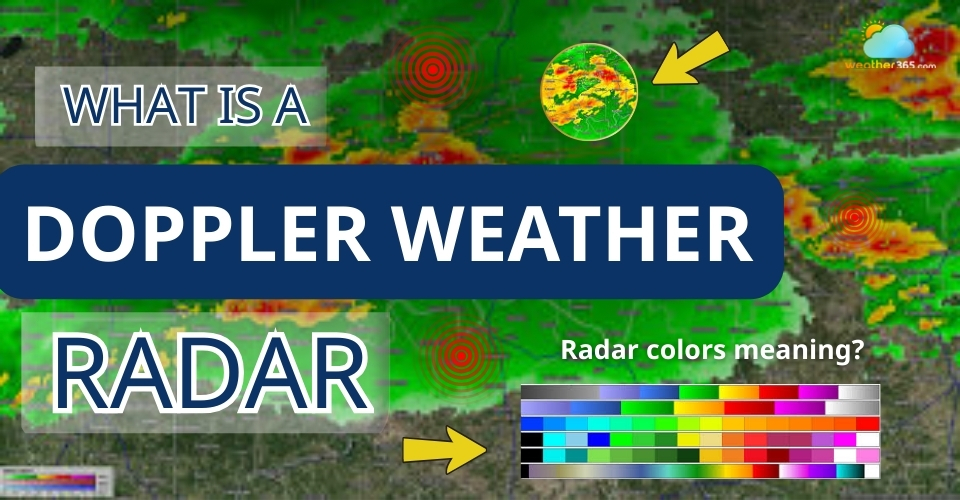
What Is A Doppler Weather Radar? A Simple Guide to How It Works
Wondering what is a Doppler weather radar and how it can “see” storms before they even reach you? This advanced technology goes far beyond simple rain detection, allowing meteorologists to track movement inside storms. Let’s explore how it works and why it plays such a key role in modern weather forecasting.
Explore what is a Doppler weather radar
- What Is A Doppler Weather Radar?
- Why It Is Called “Doppler” Radar?
- How Doppler Radar Differs From Traditional Radar?
- How Does The Doppler Weather Radar Work?
- Radar Signal Transmission
- Motion Measurement (Doppler Effect)
- How Radar Detects Precipitation and Wind Movement?
- What Doppler Weather Radar Can Detect?
- Rainfall intensity & storm structure
- Wind Direction and Wind Speed
- Severe Weather
- Non-Meteorological targets
- Limitations of Doppler Weather Radar
- How to Read Doppler Weather Radar Maps?
- Relectivity
- Velocity
- Shapes and Patterns
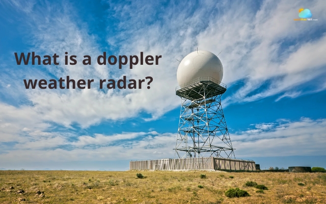
What Is A Doppler Weather Radar?
If you’ve ever checked a weather app and seen colorful radar maps showing storms moving across a region, chances are that information came from a Doppler radar system.
A Doppler weather radar is a specialized type of weather radar used by meteorologists to detect precipitation and analyze how it moves through the atmosphere.
In simple terms, it allows scientists to “see” weather systems such as rain, snow, hail, and thunderstorms, even when those systems are hundreds of kilometers away.
Doppler weather radar is used to detect precipitation
Why It Is Called “Doppler” Radar?
The word Doppler refers to the Doppler effect, a scientific principle that describes how waves change when the object reflecting them is moving.
You may have experienced this effect with sound.
For example, when an ambulance passes by, the pitch of the siren changes as it moves toward you and then away from you.
That change in sound frequency is the Doppler effect.
How Doppler Radar Differs From Traditional Radar?
Before Doppler technology was introduced, traditional weather radar systems could only show where precipitation existed and how strong it was.
While this information was helpful, it did not reveal how storms were moving internally.
Doppler weather radar changed that by adding the ability to measure velocity, or the motion of precipitation particles relative to the radar.
In other words, while traditional radar shows where precipitation is, Doppler radar also reveals how the storm is behaving.
That’s why Doppler weather radar is one of the most important tools used in operational meteorology nowadays!
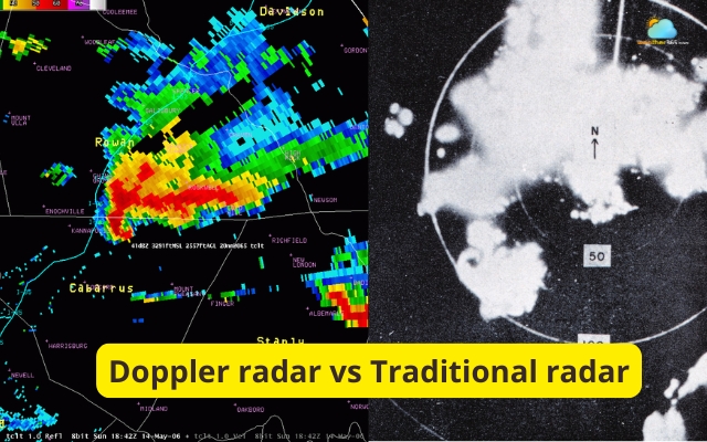
Differences between Doppler radar and traditional radar
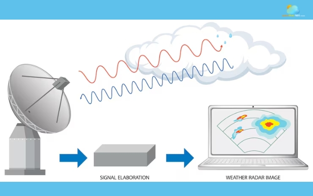
How Does The Doppler Weather Radar Work?
The weather radar may sound so complex, but how it works is surprisingly simple:
The radar sends out energy, waits for the signal to bounce back, and then analyzes the returned data.
Through this process, meteorologists can determine where precipitation is located, how intense it is, and even how air is moving within storms.
Now let’s break down the process step by step!
Radar Signal Transmission
A Doppler weather radar begins its work by sending out short pulses of microwave radio energy into the atmosphere.
These pulses are emitted from a rotating radar antenna, which continuously scans the surrounding sky in different directions and at multiple angles.
As the radar signal travels outward, it moves through the atmosphere until it encounters objects such as raindrops, snowflakes, hailstones, ice crystals,...
Doppler weather radar sends microwave radio energy to the atmosphere
When the radar waves hit these particles, part of the signal is scattered and reflected toward the radar receiver.
By measuring the time it takes for the signal to return, the radar system can calculate how far away the precipitation is.
Since radio waves travel at the speed of light, even tiny differences in return time can be used to determine the exact location of weather features.
At the same time, the strength of the returned signal also tells meteorologists something important: how intense the precipitation is.
Larger or more numerous particles reflect more energy, which usually indicates heavier rainfall or stronger storms.
Because the antenna constantly rotates and scans the atmosphere, the radar can build a complete picture of precipitation across a large region within just a few minutes.
Motion Measurement (Doppler Effect)
The unique feature that makes Doppler radar so powerful is its ability to measure motion using the Doppler effect.
The Doppler effect occurs when waves change frequency because the object reflecting them is moving.
A common real-life example is the changing sound of a passing ambulance siren - the pitch rises as the vehicle approaches and drops as it moves away.
Doppler weather radar applies this same principle using radio waves instead of sound.
When precipitation particles move within a storm, they slightly alter the frequency of the radar waves that bounce back to the radar antenna:
If the particles are moving toward the radar, the returned signal has a slightly higher frequency.
If the particles are moving away from the radar, the frequency becomes slightly lower.
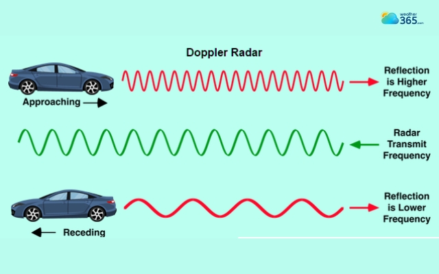
The Doppler effect occurs when waves change frequency
By analyzing these tiny shifts in frequency, the radar system can calculate the speed and direction of motion of the precipitation particles.
Since raindrops and snowflakes move with the surrounding air, this measurement allows meteorologists to estimate wind velocity inside storms.
This is extremely valuable for identifying dangerous weather patterns, such as rotating thunderstorms that may produce tornadoes.
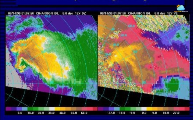
How Radar Detects Precipitation and Wind Movement?
Once the radar collects the returned signals, advanced computer systems process the data and convert it into visual radar images.
These images usually display two main types of information: reflectivity and velocity.
Reflectivity shows how strongly precipitation particles reflect radar signals. It helps meteorologists determine:
Where precipitation is occurring
How heavy the rainfall or snowfall is
The overall structure of a storm
This information is typically displayed on weather radar maps using different colors that represent varying levels of precipitation intensity.
Velocity, on the other hand, comes from Doppler measurements. It reveals whether precipitation particles are moving toward or away from the radar.
When reflectivity and velocity data are analyzed together, Doppler weather radar provides a detailed view of how storms form, develop, and move across the atmosphere.
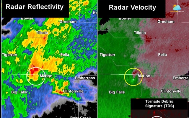
Radar reflectivity and velocity
What Doppler Weather Radar Can Detect?
Doppler radar provides meteorologists with detailed information about precipitation, wind movement, storm structure, and even some unexpected objects in the atmosphere.
Because it measures both reflected signals and motion, Doppler radar allows scientists to observe weather systems in a much more dynamic way.
Instead of just identifying precipitation, meteorologists can analyze how storms are forming, intensifying, and moving across an area.
Rainfall intensity & storm structure
One of the most fundamental functions of Doppler radar is detecting precipitation and its intensity.
When radar signals hit raindrops, snowflakes, or hailstones, they bounce back toward the radar antenna.
The strength of this returned signal tells meteorologists how much precipitation is present.
Heavier rain usually produces stronger radar reflections because there are more water droplets or larger particles in the atmosphere.
Doppler radar can detect precipitation and its intensity
By analyzing these reflections, meteorologists can estimate how intense a storm is and identify areas where rainfall may become particularly heavy.
This information helps forecasters track developing storms and evaluate potential hazards such as flash flooding, strong thunderstorms, or heavy snowfall.
Doppler radar also reveals the structure of a storm system.
Large storm cells, lines of thunderstorms, and organized weather systems often have distinct shapes that appear clearly on radar images.
Wind Direction and Wind Speed
A key advantage of Doppler radar is its ability to detect wind motion inside storms.
Because precipitation particles move along with the surrounding air, tracking their motion allows meteorologists to estimate wind speed and direction within the atmosphere.
This capability is especially important for studying storm dynamics.
For example, meteorologists can identify areas where winds are rapidly changing direction or speed, a condition known as “wind shear”.
Wind shear can play a major role in the development of severe thunderstorms.
By examining Doppler velocity data, forecasters can also detect areas where air is converging, diverging, or circulating within a storm.
These wind patterns often provide early clues about whether a storm may intensify.
Doppler weather radar allows tracking wind movement
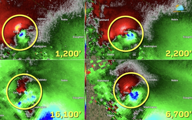
Severe Weather
Doppler weather radar plays a crucial role in identifying dangerous weather conditions.
One of its most important applications is detecting rotation inside thunderstorms.
When radar data shows winds moving toward the radar on one side of a storm and away from it on the other side, it can indicate that the storm is rotating.
This type of rotation, known as a mesocyclone, is often associated with tornado-producing storms.
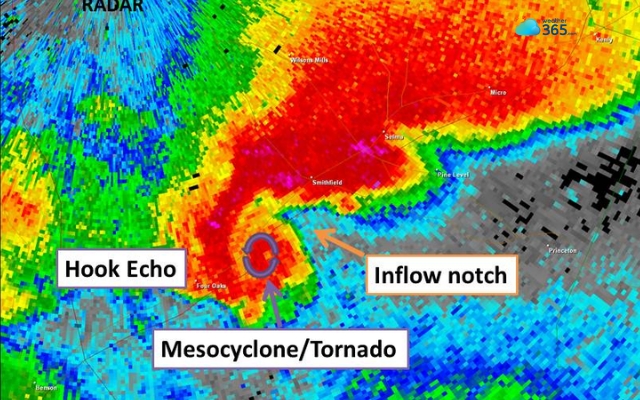
Rotation on Doppler radar indicates a mesocyclone
Because Doppler radar can detect this rotation early, meteorologists can issue tornado warnings and severe thunderstorm alerts more quickly than in the past.
In addition to tornado detection, Doppler radar helps track other severe weather features such as powerful squall lines, intense rainbands within hurricanes, and rapidly strengthening thunderstorms.
Non-Meteorological targets
Interestingly, Doppler weather radar sometimes detects objects that are not related to weather at all.
Since radar signals reflect off many types of particles and objects in the air, the system can occasionally pick up unexpected targets.
For example, radar images may show signals from birds, insects, aircraft, or even large swarms of migrating animals.
Doppler radar may detect unexpected targets
In some cases, radar has also detected smoke plumes from wildfires or dust clouds carried by strong winds.
Although these signals are usually filtered out during weather analysis, they can still appear on radar displays and sometimes provide useful information for researchers studying atmospheric or ecological patterns.
Limitations of Doppler Weather Radar
Doppler weather radar is one of the most powerful tools in modern meteorology.
It allows forecasters to track storms, measure wind movement, and monitor precipitation in near real time.
However, like any technology, it is not perfect.
Several physical and technical factors can limit how accurately radar represents what is happening in the atmosphere.
Earth’s Curvature
One important limitation comes from the curvature of the Earth. Radar beams travel in straight lines, but the Earth’s surface curves away beneath them.
As the radar beam moves farther from the radar station, it gradually scans higher and higher levels of the atmosphere.
This means that storms located far away may only be detected at higher altitudes.
Rain or snow occurring closer to the ground might not appear clearly on radar when it is very distant from the radar site.
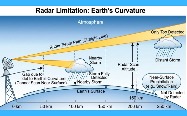
Earth’s surface curves away beneath radar beams
Range limitation
Radar accuracy also decreases with distance. As the radar signal spreads out over a larger area, the data becomes less precise.
Small weather features may be harder to detect, and precipitation intensity estimates may become less reliable.
For this reason, radar images are usually most accurate within a few hundred kilometers of the radar station.
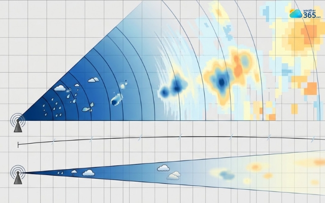
Radar accuracy also decreases with distance
Cone of silence
Directly above a radar antenna, there is an area that the radar cannot scan effectively. This region is known as the cone of silence.
Radar antennas tilt upward at several angles as they scan the sky, but none of those angles point directly overhead.
Because of this, weather occurring right above the radar site may not be fully captured.
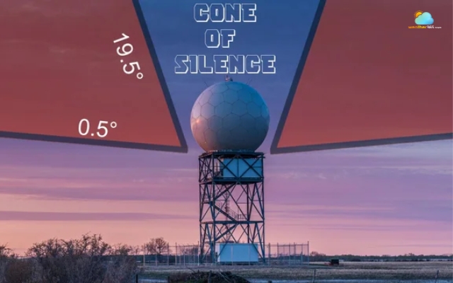
Cone of silence is a circular area above the radar station
Beam blockage
Physical obstacles can sometimes interfere with radar signals. Mountains, tall buildings, and even dense terrain can partially block the radar beam.
When this happens, the radar may fail to detect precipitation located behind these obstacles. Beam blockage is especially common in mountainous regions where terrain can interrupt the radar’s line of sight.
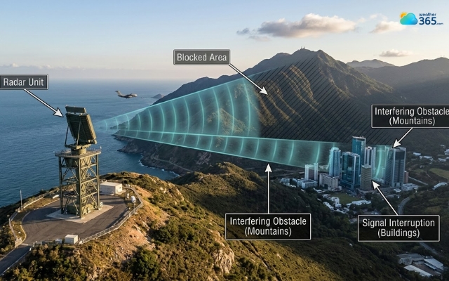
Radar signals can be blocked by hindrances
Attenuation
Another limitation occurs during very heavy precipitation.
When radar signals pass through heavy rain or hail, some of the energy is absorbed or scattered before reaching the radar again.
This effect, known as attenuation, can make storms appear weaker on radar than they actually are because the signal becomes weakened before returning to the receiver.
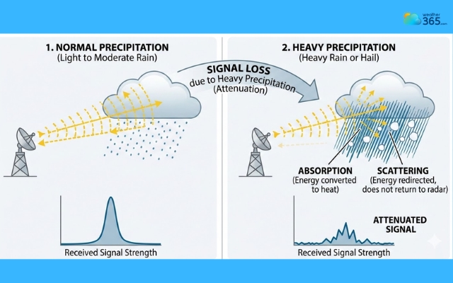
Attenuation makes storms appear weaker on radar
Non-meteorological echoes
Radar systems sometimes detect objects that are not related to weather. Birds, insects, aircraft, smoke, and even airborne dust can reflect radar signals.
These signals, called non-meteorological echoes, may appear on radar images and sometimes need to be filtered out by meteorologists to avoid confusion with real precipitation.
Velocity aliasing
Doppler radar measures wind motion by analyzing changes in signal frequency. However, there is a maximum velocity the radar can measure accurately.
When wind speeds exceed that limit, the radar may misinterpret the motion and display incorrect velocity data.
This issue is known as velocity aliasing and can occasionally complicate the interpretation of strong storm systems.
Radar incorrectly measures the speed of a target
How to Read Doppler Weather Radar Maps?
Doppler weather radar colors often confuse people; however, once you understand their meanings, you can easily read the maps.
Relectivity
Reflectivity is the most common radar display and the one you usually see in weather apps. It shows how strongly precipitation particles reflect the radar signal.
In simple terms, reflectivity tells us how intense the precipitation is.
The stronger the returned signal, the heavier the rain or storm activity is likely to be.
This information is typically represented using different colors on the radar map:
Light Green: Light rain or mist.
Dark Green: Moderate rain
Yellow: Heavy rain.
Orange: Very heavy rain, potential for strong thunderstorms.
Red: Intense rain
Pink/Purple: Very heavy rain, hail, or intense thunderstorms.
Just looking at the color patterns, you can quickly identify where the strongest storms are located and how large the precipitation area is.
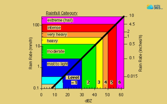
Color indications of Doppler weather radar
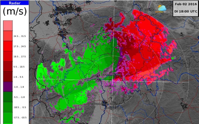
Velocity
Another important Doppler radar feature is velocity, which shows the movement of precipitation particles relative to the radar.
Velocity maps typically use different colors to represent motion.
Green or blue shades generally indicate winds moving toward the radar, while red or orange shades represent winds moving away from the radar.
Meteorologists pay close attention when these colors appear next to each other.
Green or blue shades indicate winds moving toward the radar
A tight area where red and green meet can suggest that the winds are rotating. In certain situations, this rotation may signal the development of a tornado-producing storm.
Even for everyday weather, velocity data helps forecasters understand how storms are moving and how wind patterns are evolving.
Shapes and Patterns
Meteorologists also look for specific radar shapes that reveal important storm characteristics.
One well-known pattern is the hook echo, which appears as a curved hook-like structure on radar images.
This feature can indicate a rotating thunderstorm and is often associated with tornado formation.
Another recognizable structure is the bow echo, which looks like a bow-shaped line of storms.
Bow echoes are commonly linked with strong straight-line winds that can cause widespread damage.
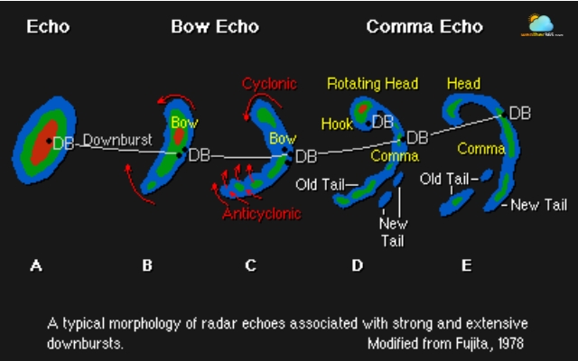
A bow echo looks like a bow-shaped line of storms
The most common radar display, known as base reflectivity, simply shows the intensity of precipitation across an area.
By analyzing this view together with velocity data, meteorologists can better understand both the strength and movement of a storm.
Final Thought
What is a Doppler weather radar, and why does it matter? In short, it’s one of the key tools meteorologists use to watch storms in real time. By tracking both precipitation and wind movement, Doppler radar helps us better understand how storms develop, move, and sometimes become severe. Knowing how it works makes weather maps much easier to read.
Frequently Asked Questions (FAQs)
Related post

Symbols On Weather Explained: Master The Weather Maps Like a Pro

What Is The GFS Weather Model: Accuracy, Uses & Comparison Explained

0 Comment
Leave a comment
Your email address will not be published. Required fields are marked *