




Category 5 Hurricane Polo Intensifies Off Mexico, Fueling Southwest US Flood Threat


MEXICO CITY — Hurricane Polo rapidly exploded into a historic Category 5 storm off Mexico's Pacific coast Tuesday, packing winds of 180 mph. While the core remains offshore, the massive storm is battering coastal areas with dangerous waves and torrential rain. Furthermore, its tropical moisture is surging north, triggering life-threatening flash flood emergencies across the U.S. Southwest. Here are the latest updates!
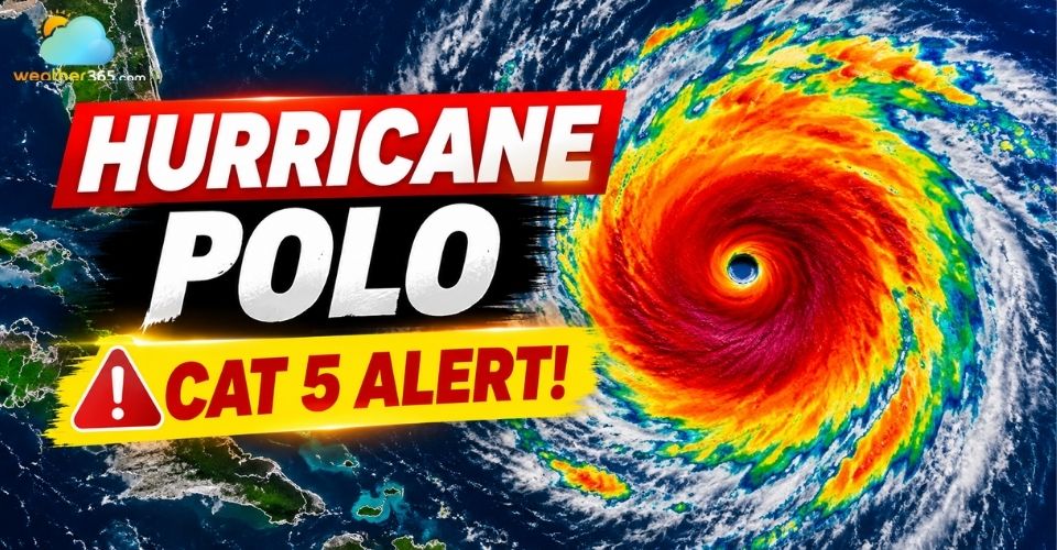
Hurricane Polo intensifies off Mexico coast
Hurricane Polo Explodes Into Historic Category 5 Storm
Hurricane Polo made meteorology history on Tuesday morning as it rapidly intensified into a Category 5 monster storm in less than 24 hours.
The storm's maximum sustained winds increased by an incredible 110 mph over a single day, marking the second-fastest rate of rapid intensification ever recorded in the Pacific Ocean.
Explore more: Beaufort wind scale chart
Data from Hurricane Hunter reconnaissance flights revealed that Polo's central pressure plummeted to 892 millibars.
This ranks as the second-lowest atmospheric pressure ever documented in the eastern or central Pacific basin.
With peak winds tied for the third-highest ever seen in the region, experts point to supercharged ocean surface temperatures fueled by a strengthening El Niño pattern as the primary driver behind this sudden explosion.
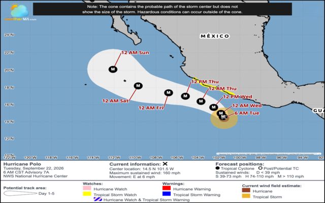
Projected path of Hurricane Polo. Sep.22, 2026 (Source: NOAA)
Mexico Coast Braces for Heavy Rainfall and Mudslides
As the center of Hurricane Polo parallels the west-central coast of Mexico, localized communities are bracing for severe impacts.
Tropical Storm Warnings remain active from Tecpan de Galeana to Punta San Telmo, with watches extending further west toward Playa Perula.
Outer rainbands are churning up hazardous coastal conditions.
Heavy rainfall threatens to trigger life-threatening flash floods and catastrophic mudslides across mountainous terrain.
High surf and destructive storm surge continue to pound popular beach areas, including Zihuatanejo and Acapulco.
Forecast models project the storm will begin turning northwest away from the immediate coastline, eventually weakening as it moves toward Baja California later in the week.

Hurricane Polo can bring torrential rain and mudslide risk
Check real-time wind speeds and rain accumulation for Zihuatanejo to stay updated on coastal conditions!
U.S. Issues Flash Flood Emergencies for New Mexico
Even while remaining hundreds of miles south of the U.S. border, hurricane Polo's expansive plume of tropical moisture is supercharging monsoon weather patterns across the U.S. Southwest.
According to the National Weather Service in Albuquerque, widespread heavy rainfall will lead to a high risk of life-threatening flash flooding across major portions of New Mexico.
A Flash Flood Emergency has already been declared in Mora County, where local authorities are conducting rescues and ordering mandatory evacuations.
The heavy precipitation zone is extending into Arizona and cities like Roswell and Albuquerque.
Meanwhile, further west, powerful ocean swells generated by Polo are pounding the Southern California coastline, creating treacherous rip currents and high surf from San Diego up to Los Angeles.
FLOOD SAFETY TIPS
|
If you live in or near Albuquerque, monitor local river levels, active flash flood warnings, and hourly rainfall forecasts on our Albuquerque live weather dashboard now.
Hurricane Polo is not the only active storm in a supercharged Pacific Ocean.
Meteorologists are closely watching Tropical Storm Odalys further west, which could interact with Polo and alter forecast tracks over the coming days.
Additionally, moisture from former tropical systems continues to threaten Hawaii with heavy rain, making this one of the most volatile Pacific storm seasons in recent history.
References
FOX Weather
AP News
CNN
Reuters
LA Times
Related post

Hurricane prep list: What you need BEFORE - DURING - AFTER storm
 204
204
 8
8
 5.0
5.0
 26/08/2026

When is hurricane season in the Atlantic Ocean and Pacific Ocean? Key dates
166
8
5.0
06/08/2026
Difference Between Hurricane Watch and Warning: What You Need to Know
94
8
4.9
06/08/2026

0 Comment
Leave a comment
Your email address will not be published. Required fields are marked *