

Tropical Storm Erin Becomes Season’s First Hurricane, U.S. Impact Unlikely
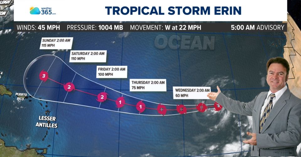
Tropical Storm Erin is expected to intensify into the first hurricane of the Atlantic season by Friday morning and strengthen further into a major Category 3 hurricane by Sunday morning as it moves north of Puerto Rico.
Current forecasts indicate Erin will not pose a direct threat to the United States.
Tropical storm Erin
This weekend, Puerto Rico could see tropical rainfall from Erin’s outer bands, though impacts are expected to be minimal.
However, dangerous rip currents will be a major hazard for Puerto Rico and much of the Caribbean.
Forecast models show Erin likely turning north afterward, tracking either directly toward Bermuda or passing just west of the island.
Around August 20, as the storm nears Bermuda, it may maintain Category 3 intensity or strengthen further over unusually warm waters.
With Erin still a week away, meteorologists in Bermuda and along the U.S. East Coast will monitor its path closely, as any shift east or west could bring significant impacts.
While a direct U.S. landfall is not expected, dangerous rip currents are forecast to affect the East Coast from approximately August 21 to 27.
The National Hurricane Center has already predicted an above-normal Atlantic hurricane season, with August, September, and October being the peak months before the season officially ends on November 30.
Alongside tracking Erin, the National Hurricane Center (NHC) is also monitoring a disturbance in the southwest Gulf of Mexico, now designated as Invest 98L.
Currently situated over Mexico’s Yucatán Peninsula, the system is moving west-northwest and is expected to emerge over the Gulf waters by Thursday. As of 8 p.m. Wednesday, the NHC has raised development odds to 20% for both the two-day and seven-day outlooks — up 10% from Wednesday morning.
With its invest designation, tropical weather forecast models will soon begin providing detailed projections of the system’s potential track over the next 24 hours. Areas in eastern Mexico and southern Texas are most likely to experience impacts, primarily in the form of heavy rainfall.
Related post

Is Atlantic hurricane season slowing down? Here's what experts say about the delay

Hurricane in Florida Coast Expected to Develop Slowly, Experts say

0 Comment
Leave a comment
Your email address will not be published. Required fields are marked *