

NOAA predicts above-normal hurricane season in the Atlantic in 2025
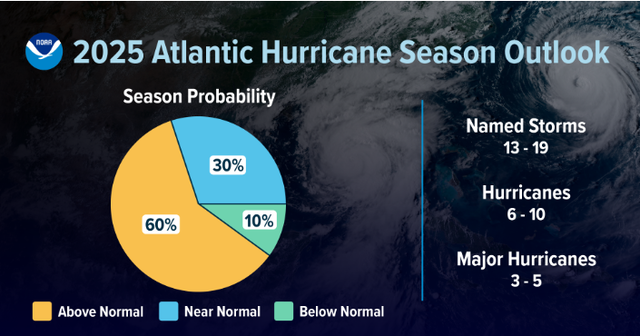
Hurricane season in the Atlantic starts from June 1 to November 30. NOAA predicts storm outlook for 2025 with many surprising numbers. a 30% chance of a near-normal season, but up to 60% chance of an above-normal, and 10% chance of a below-normal hurricane season.
Predict the above-normal hurricane season in the Atlantic
2025 Atlantic hurricane season outlook
Many scientists believe that hurricane seasons are becoming more intense due to climate change. While the total number of named storms may not increase significantly, the chances of major hurricanes are rising.
According to NOAA, there is a 30% probability of a near-normal hurricane season, a 60% chance of an above-normal season, and a 10% chance of a below-normal season.
NOAA’s forecast predicts between 13 and 19 named storms (with winds of 39 mph or higher).
Out of these, 6 to 10 are expected to develop into hurricanes (winds of 74 mph or higher), including 3 to 5 major hurricanes (Category 3, 4, or 5, with winds exceeding 111 mph). NOAA expresses 70% confidence in these projections.
“NOAA and the National Weather Service are leveraging the most advanced weather models and state-of-the-art hurricane tracking systems to deliver real-time storm forecasts and warnings to Americans,” said Commerce Secretary Howard Lutnick. “Thanks to these technologies, we are better prepared than ever for hurricane season.”
The 2025 Atlantic Hurricane season outlook ( Source: NOAA)
“As we saw last year with the severe inland flooding caused by hurricanes Helene and Debby, hurricane impacts extend well beyond coastal areas,” added Acting NOAA Administrator Laura Grimm. “NOAA plays a vital role in providing early, accurate forecasts and warnings, backed by scientific expertise essential for saving lives and protecting property.”
Factors contributing hurricane season in the Atlantic
Here are some factors contributing to the above-normal hurricane season:
-
Warmer than average ocean temperatures: A warmer ocean and a reduction of trade winds provide more energy to fuel tropical storms.
-
Northward shift of the West African Monsoon: This monsoon often initiates Atlantic hurricanes.
-
High ocean heat content in the Atlantic Basin: Offers abundant energy for storm formation and intensification. Weaker winds reduce disruption, enabling storms to grow stronger.
NOAA’s National Weather Service Director Ken Graham emphasizes the unprecedented advancement in forecasting tools and urges everyone to prepare proactively for the season ahead.
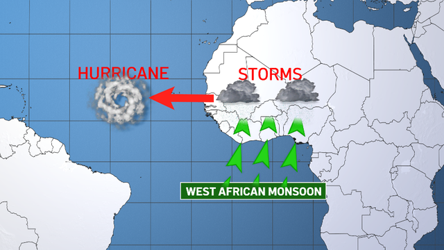
The west African monsoon contributes to the hurricane season
Improved analysis and forecasts
This season, NOAA will enhance its storm recovery, decision support, and prediction messaging.
These include:
-
Upgraded Forecast Model: The Hurricane Analysis and Forecast System will be enhanced, improving tracking and intensity forecasts by about 5%, enabling more accurate watches and warnings.
-
Earlier Advisories: The National Hurricane Center (NHC) and Central Pacific Hurricane Center can now issue tropical cyclone advisories up to 72 hours before storm surge or tropical-storm-force winds reach land, giving communities more preparation time.
-
Extended Tropical Hazards Outlook: The Climate Prediction Center’s Global Tropical Hazards Outlook has been extended from two to three weeks, allowing earlier notice of potential tropical cyclone risks.
-
Spanish Language Products: NHC will provide key tropical weather products, including outlooks and advisories, in Spanish to better serve Spanish-speaking communities.
-
Enhanced Forecast Cone Graphic: An experimental forecast cone will show inland tropical storm and hurricane watches/warnings, highlighting areas with simultaneous hurricane and tropical storm alerts.
-
Rip Current Risk Map: NHC will issue rip current risk maps when tropical systems are active, using local data to warn about dangerous surf conditions caused by distant hurricanes.
-
New Radar Technology (ROARS): NOAA is deploying an experimental electronically scanning radar system on hurricane hunter aircraft to gather detailed data on ocean waves and hurricane wind structures.
-
Probabilistic Precipitation Portal: An experimental tool from the Weather Prediction Center offers accessible forecasts for rain and flash flooding up to three days ahead, helping communities prepare for heavy rainfall events like those seen with Hurricane Helene in 2024.
These advancements aim to enhance forecast accuracy, communication, and community preparedness throughout the hurricane season
Related post

What is the difference between a hurricane typhoon and cyclone? Interesting Explanation

Is Atlantic hurricane season slowing down? Here's what experts say about the delay

0 Comment
Leave a comment
Your email address will not be published. Required fields are marked *