




Tropical storm Arthur moves to the Texas Coast, flood risk across Southern US


Tropical Storm Arthur developed on Wednesday after a large area of showers and thunderstorms over South Texas and northern Mexico became more organized. The storm is expected to bring widespread heavy rainfall, dangerous flooding, travel disruptions, and potential property damage across parts of the Gulf Coast and the southeastern United States through the end of the week.
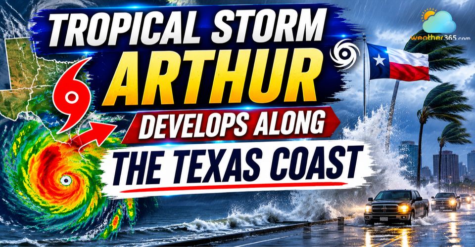
Arthur storm develops along the Texas coast
Tropical Storm Arthur Makes Landfall in Texas
The system formed from a combination of several weather features, including moisture left behind by former eastern Pacific Tropical Storm Cristina, a tropical wave moving westward from Africa, a stalled frontal boundary, and favorable conditions in the upper atmosphere.
Together, these ingredients helped create an environment capable of supporting tropical development.
After strengthening into Tropical Storm Arthur, the storm moved along the Texas coastline before making landfall northeast of Matagorda Bay on Wednesday afternoon.
While the center of circulation is forecast to drift farther inland, meteorologists are closely monitoring the possibility of the storm reorganizing near the Gulf Coast.
Forecasters note that a large concentration of thunderstorms remains east of the storm's center, raising the possibility that the circulation could reform closer to the coastline.
If that occurs, tropical-storm-force winds could persist longer than currently expected in coastal areas of Texas and Louisiana.
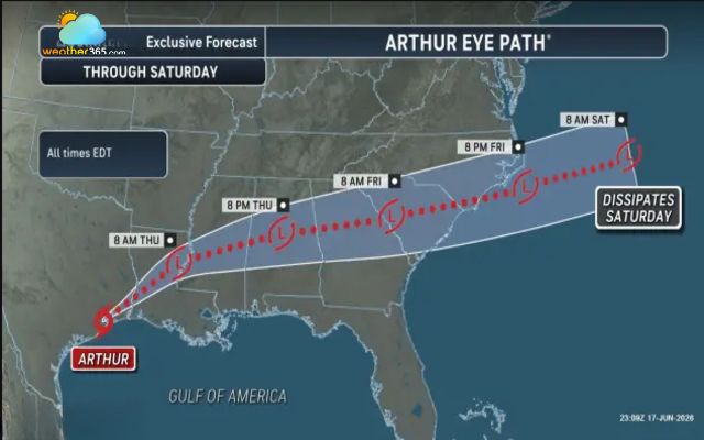
Storm Arthur eye path
Although Tropical Storm Arthur is expected to weaken as it moves inland, its most significant threat is not wind but flooding rainfall. Before receiving its official name, the system had already been identified as a serious flood threat.
The National Hurricane Center classified it as a Potential Tropical Cyclone before it strengthened into a tropical storm. By Wednesday afternoon, Arthur's maximum sustained winds had reached 45 mph.
A Tropical Storm Warning remains in effect from Sargent, Texas, to Morgan City, Louisiana. Fortunately, forecasters do not expect Arthur to rapidly intensify into a hurricane because of its limited time over the warm waters of the Gulf of Mexico.
Heavy Rainfall and Flooding Threat Expands Eastward
While wind impacts are expected to remain relatively modest, rainfall totals could become extreme in some locations. Tropical Storm Arthur will enhance moisture already present across the region, producing repeated rounds of heavy rain.
In the most intense thunderstorms, rainfall rates could exceed 2 to 3 inches per hour, quickly overwhelming drainage systems and causing flash flooding in urban and low-lying areas.
Forecast models indicate a broad corridor of 4 to 8 inches of rainfall extending from South Texas to eastern Alabama. Within this zone, many communities could receive between 8 and 12 inches of rain over several days.
Isolated areas may experience even greater totals, with localized accumulations approaching 20 inches.
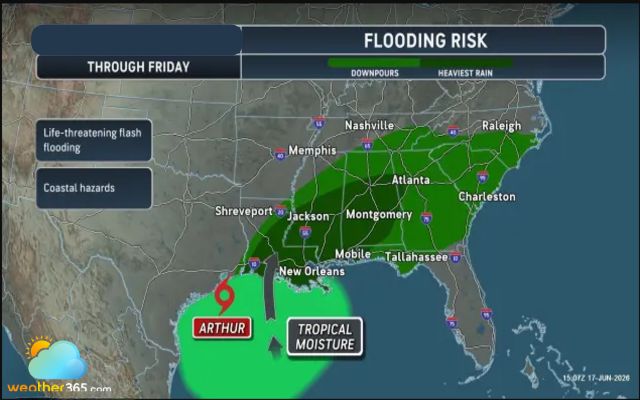
Flooding risk in Texas
Flooding impacts are expected to develop rapidly. Small streams, drainage channels, and roadside ditches could overflow within hours of the heaviest rainfall. As runoff moves downstream, larger rivers and bayous may also rise significantly, increasing the risk of moderate to major flooding through the weekend and into early next week.
Several Texas rivers face elevated flood risks, including the Guadalupe, Brazos, Trinity, Colorado, Nueces, San Antonio, and Neches rivers. Further east, waterways such as the Sabine, Calcasieu, Pearl, Tombigbee, and Alabama rivers may also experience substantial rises as floodwaters spread across the region.
Forecasters warn that the flood threat will gradually shift eastward during the second half of the week, affecting Louisiana, Mississippi, Alabama, Georgia, and portions of the Florida Panhandle.
Coastal Hazards, Severe Weather, and Future Outlook
Beyond the flooding threat, Tropical Storm Arthur will generate rough marine conditions throughout much of the northwestern Gulf of Mexico. Choppy seas, dangerous surf, and hazardous boating conditions are expected to continue for several days.
The storm could also contribute to severe weather. Strong thunderstorms embedded within Arthur's rain bands may produce damaging wind gusts, isolated tornadoes, and waterspouts.
Areas from the upper Texas coast to southern Louisiana, as well as portions of Mississippi, Alabama, and the Florida Panhandle, could experience these hazards.
Wind gusts ranging from 40 to 60 mph remain possible along sections of the upper Texas and western Louisiana coasts. Coastal communities may also face storm surge flooding, with water levels expected to rise 1 to 3 feet above normal.
In areas near Arthur's landfall location, localized surge heights of 3 to 6 feet are possible.
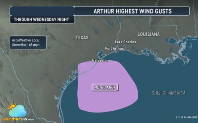
Arthur highest wind gusts
Looking ahead, forecasters are monitoring whether Tropical Storm Arthur can survive its journey across the southeastern United States. If the system remains intact, it could re-emerge over the Atlantic Ocean near the Carolinas later this weekend and potentially regain some strength. Another scenario involves Arthur's remaining moisture helping to form a new non-tropical low-pressure system offshore.
Regardless of its future track, Tropical Storm Arthur is expected to bring significant flooding concerns across a large portion of the Gulf Coast and Southeast, making rainfall and flood preparedness the top priority for residents in affected areas.
Related post

Weather for World Cup: Match-by-Match Forecast Across U.S. Host Cities
 219
219
 0
0
 4.9
4.9
 26/06/2026
Thunderstorm in DC With 60 MPH Gusts Leaves Thousands Without Power
216
0
4.9
12/06/2026
Midwest Derecho Leaves Over 500,000 Without Power Across Multiple States
178
0
4.8
11/06/2026

0 Comment
Leave a comment
Your email address will not be published. Required fields are marked *