




Tropical Depression Nine Forms in Gulf, Set to Become Hurricane Isaias


Tropical Depression Nine is strengthening over the Gulf of America and could become Hurricane Isaias later this week. The system is expected to move toward the northern Gulf Coast, bringing heavy rain, flash flooding and severe weather to parts of the Southeast. Louisiana, Mississippi, Alabama and the Florida Panhandle could face the greatest impacts as the storm develops and moves closer to the U.S. coast. Here are the latest updates.
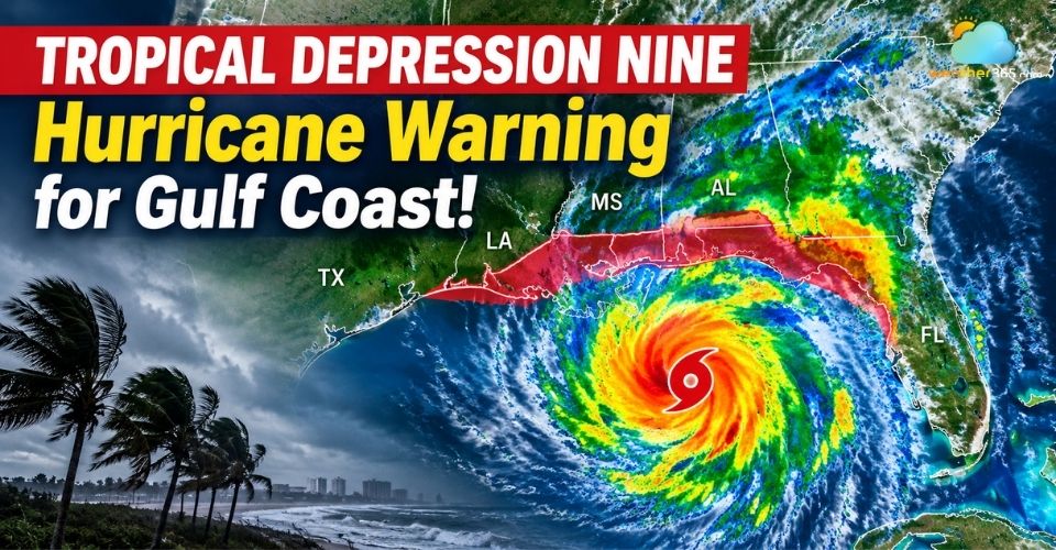
Tropical Depression Nine strengthens over the Gulf of America
Quick Takeaway
🌀 Current Status | 📍 Expected Path |
Tropical Depression | Gulf → Northern Gulf Coast |
Winds: ~35 mph | Potential approach: Friday |
🌧️ Rainfall Threat | ⚠️ Flood Risk |
Several inches possible | Level 2/4 risk |
Gulf Coast → Southeast | Flash flooding possible |
Tropical Depression Nine Forms in the Gulf of America
Tropical Depression Nine formed off the coast of Mexico in the Gulf of America on October 6 and is becoming better organized.
The system currently has maximum sustained winds near 35 mph and is moving east at about 5 mph.
A tropical depression has winds of 38 mph or less and is identified by a number until it strengthens into a named tropical storm.
The National Hurricane Center (NHC) expects the system to strengthen into a tropical storm on Wednesday. It would then receive the name Isaias.
The forecast calls for further intensification, with the system potentially reaching Category 2 hurricane strength by Friday night.
At that stage, winds could reach around 100 mph.
Warm Gulf waters could support this rapid strengthening. Sea surface temperatures in the Gulf are currently at their warmest levels on record in data going back to 1982.
Warm water can provide more energy for a developing tropical system.
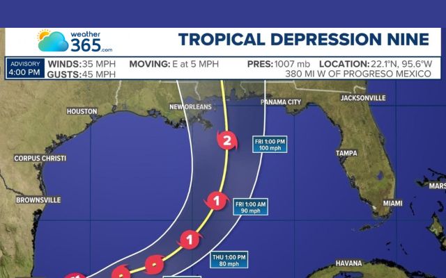
Tropical Depression Nine could reach max 100 mph winds
Check the latest weather conditions and forecast for Louisiana communities to stay informed.
Tropical Depression Nine Track and Forecast Path
The current forecast track takes Tropical Depression Nine eastward before turning toward the northeast.
The system is expected to pass north of the Yucatán Peninsula on Thursday and approach the northern U.S. Gulf Coast on Friday.
Its projected path puts parts of Louisiana, Mississippi, Alabama and the Florida Panhandle in the main area of concern.
However, the forecast track can still change as the system develops. The forecast cone shows the possible path of the storm's center.
It does not mean every location inside the cone will experience the same conditions, or that areas outside it will avoid impacts.
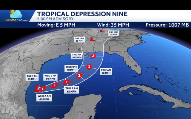
Tropical Depression Nine is forecast to pass north of the Yucatán Peninsula on Thursday (Gulf Coast News)
Escalating Flash Flood and Severe Weather Risks
Heavy rain and flash flooding could become major threats as Tropical Depression Nine moves toward the U.S. Gulf Coast.
The National Weather Service’s Weather Prediction Center (WPC) has issued a Level 2 of 4 flash flood risk for parts of the Southeast on Friday and Saturday.
Rainfall could be especially heavy along and near the storm’s projected path.
Areas from southeastern Louisiana to the Florida Panhandle may see several inches of rain.
Saturated ground, fast-rising streams and heavy downpours could increase the risk of flash flooding in low-lying and flood-prone areas.
The storm could also bring a broader severe weather threat.
Strong tropical moisture can interact with other weather systems and fuel thunderstorms as the system moves inland.
These storms may produce damaging winds, frequent lightning and locally intense rainfall.
Recent WPC forecasts have also highlighted the potential for severe thunderstorms and flooding across parts of the Southern Plains and Southeast as moisture moves through the region.
The flood threat may extend beyond the immediate landfall area.
Residents should not focus only on the storm’s center or forecast cone, as heavy rain and flooding can affect communities well away from the center.
Don’t miss

Gulf Coast communities face high risk of widespread flooding
Residents along the Gulf Coast should closely monitor updates from the National Hurricane Center and local emergency officials.
People in flood-prone areas should prepare for heavy rain, flash flooding and possible changes to local evacuation guidance.
It is also important to secure outdoor items and keep essential supplies ready before conditions worsen.
Tropical Depression Nine is still developing, so its strength and track may change over the next few days.
Stay updated with the latest weather news & forecast on Weather365!
References
FOX Weather
NY Times
Qazinform
Related post

10 Worst flood in US history - What lessons we can learn from disasters
 223
223
 8
8
 4.7
4.7
 26/08/2026

Heavy Rain Brings Severe Flood Threat in Florida This Week
59
0
4.8
06/10/2026


0 Comment
Leave a comment
Your email address will not be published. Required fields are marked *