




Hurricane Trudy Moves Away From Mexico as Flood Threat Persists


Hurricane Trudy is moving farther into the Pacific after bringing strong winds and heavy rain to Mexico’s western coast. While the storm is expected to weaken, the threat is not over: saturated ground and additional rainfall could trigger flooding and landslides. Authorities are also continuing recovery work in areas hit by separate severe weather.

Hurricane Trudy weakens off Mexico coast
🌀 Hurricane Trudy: Storm Snapshot
Current status: Weakening offshore
Maximum sustained winds: 100 mph (155 km/h)
Movement: Northwest at 6 mph (9 km/h)
Main threats: Heavy rain, flash flooding and landslides
Affected region: Mexico’s Pacific coast, including Michoacán, Colima and Jalisco
Based on reports published October 18–19, 2026. Wind and movement figures reflect an earlier advisory, not live conditions.
Hurricane Trudy was moving northwest over the Pacific on Sunday, October 18, with sustained winds of around 100 mph (155 km/h).
The Category 2 storm was located approximately 180 miles (290 km) west-northwest of Manzanillo, according to the U.S. National Hurricane Center (NHC).
Forecasters expected Trudy to move farther from mainland Mexico before passing south of Baja California Sur on Monday and Tuesday.
With the hurricane forecast to weaken rapidly, Mexican authorities discontinued all hurricane and tropical storm warnings along the Pacific coast and the Islas Marias archipelago.
However, officials urged people in southwestern and west-central Mexico to keep monitoring the storm’s progress.
Coastal communities may still face hazardous conditions even as the center moves offshore.
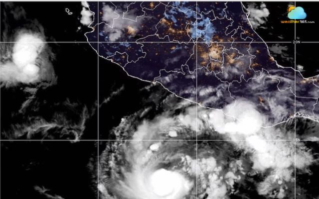
Hurricane Trudy is forecast to weaken rapidly (Photo: ABC News)
Rainfall remains a key concern across western Mexico.
Earlier forecasts indicated that parts of Michoacán, Colima and Jalisco could receive 4–8 inches (10–20 cm) of rain, with isolated totals reaching around 12 inches (30 cm).
The risk is particularly high in mountainous areas, where intense rainfall can cause sudden flooding and landslides.
Ground already saturated by previous storms may have limited capacity to absorb additional water, increasing the danger even as Trudy weakens.
Residents should avoid flooded roads, stay clear of fast-moving water and follow local emergency guidance.
Location | Key concern |
Heavy rainfall | |
Flooding and runoff | |
Flash floods and landslides | |
Monitor storm movement |
Elsewhere, a separate weather system, Cold Front No. 2, has brought severe weather to southern and southeastern Mexico.
In Veracruz, more than 1,500 homes were affected by floodwaters, prompting cleanup and recovery operations as water levels gradually declined.
Authorities were also monitoring rivers and reservoirs in Veracruz, Tabasco, Chiapas and Oaxaca.
Strong northerly winds and waves reaching up to 6 meters (20 feet) had contributed to coastal flooding and road closures in parts of Tabasco.
The separate flooding highlights the wider challenges facing communities across the region.
To stay safe, resident should:
Avoid driving or walking through floodwater
Stay away from swollen rivers and unstable slopes
Follow local emergency alerts and evacuation instructions
Stay informed with the latest weather updates and breaking weather news on Weather365.
References
AP News
NCB News
Internazionale
Related post

Flooding in Istanbul Disrupts Roads, Schools and Emergency Services
 692
 0
 4.7
 16/10/2026

Super El Nino 2026: NOAA Warns of Historic Record-Breaking Winter Impact
220
8
4.8
14/10/2026
Hurricane Simon Threatens Mexico and Fuels US Flood Risks
75
0
4.6
12/10/2026

0 Comment
Leave a comment
Your email address will not be published. Required fields are marked *