

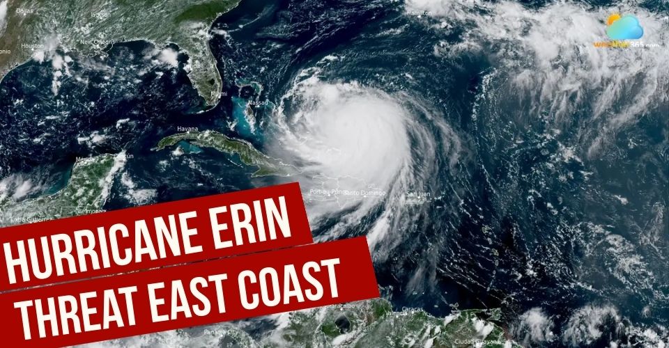
Hurricane Erin Triggers Dangerous Waves To The Entire US East Coast
Hurricane Erin is poised to send deadly rip currents across the U.S. East Coast, while destructive waves and storm surge threaten North Carolina’s Outer Banks. At the same time, the Atlantic hurricane season is ramping up, with the potential for another named storm to form in Erin’s wake.
Tracking hurricane Erin
Hurricane Erin
Erin, a sprawling Category 3 hurricane that rapidly intensified over the weekend, is not expected to make landfall.
Still, it will generate life-threatening surf conditions as it tracks north along the East Coast. Similar hazards are forecast for Bermuda to the storm’s east.
The dangers are already being felt. On Monday, officials in New Hanover County, North Carolina, reported at least 75 rip-current rescues. Wrightsville Beach has since issued a no-swim advisory through Friday.
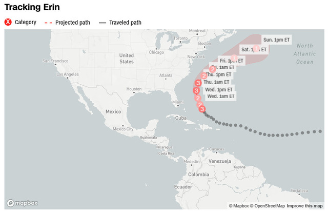
Tracking Erin
A tropical storm watch is in effect from the central North Carolina coast northward past Kitty Hawk, including the Pamlico Sound. The alert signals that tropical-storm-force winds (39–73 mph) are possible within the next 48 hours.
Local officials in Dare and Hyde counties—covering much of the Outer Banks—have declared states of emergency and ordered mandatory evacuations for Hatteras and Ocracoke islands.
Farther south, tropical storm warnings remain in place for the Turks and Caicos Islands and the southeast Bahamas, while a tropical storm watch extends across the central Bahamas. Erin’s outer bands have already lashed these islands in recent days, triggering flooding, power outages, and airport closures.
Puerto Rico also endured severe impacts, including heavy flooding and widespread loss of electricity.
Meanwhile, the National Hurricane Center is tracking other systems in the Atlantic. A tropical wave trailing Erin has a 60% chance of developing into a depression or named storm within a week.
If it strengthens, it would become Tropical Storm Fernand, the sixth named system of the season. A third disturbance just off the coast of Africa currently carries a low chance of development but could intensify as it moves westward across the Atlantic.
Devastating impact of Erin
Hurricane Erin is forecast to remain a powerful Category 3 or stronger hurricane through at least midweek.
While the storm is not expected to make direct landfall, its greatest impacts will come from the ocean: large pounding surf, dangerous rip currents, and coastal flooding during high tides.
According to the National Weather Service, waves reaching 20 feet or higher are expected along the Outer Banks, likely causing extensive beach erosion.
Officials warn that such waves could inundate and destroy protective dune systems, pushing floodwaters farther inland.
The National Park Service at Cape Hatteras National Seashore cautioned that the flooding could be severe.

Homes in Dare County are expected to be influenced heavily by Erin
The Outer Banks has already lost multiple homes to ocean erosion in recent years, including three destroyed by Hurricane Ernesto’s surf around this time last year.
This week, at least two homes in Rodanthe, North Carolina, are considered “very, very vulnerable” to collapse, according to Superintendent Dave Hallac of Cape Hatteras National Seashore.
To make matters worse, tides around the Outer Banks will peak at their highest levels of the month on Wednesday and Thursday. Combined with Erin’s massive waves, this could bring serious coastal flooding to the region.
Beyond the U.S. coastline, Bermuda is also expected to feel Erin’s effects, with forecasters predicting very rough seas and the possibility of tropical-storm-force winds later this week.
You may also like this: Hurricane safety tip
Historic intensification
Hurricane Erin delivered a powerful start to the peak of Atlantic hurricane season, undergoing one of the fastest rapid intensification events on record.
In just over 24 hours, Erin exploded from a tropical storm to a Category 5 hurricane, peaking at 160 mph winds on Saturday as it drew energy from unusually warm ocean waters and favorable atmospheric conditions.
The storm’s massive size has extended its reach across the Atlantic. As of early Tuesday, Erin’s hurricane-force winds stretched 80 miles from its center, while tropical-storm-force winds extended up to 230 miles, according to the National Hurricane Center.
Erin’s development highlights how climate change is fueling stronger, faster-growing hurricanes. It is rare to see a Category 5 storm form so early in the season and outside the Gulf or Caribbean.
While Erin has begun mixing cooler waters to the surface, the Atlantic still holds well-above-average sea surface temperatures, providing ample fuel for storms.
This surge comes as the busiest period of hurricane season—mid-August through mid-October—begins. With warm waters and favorable conditions in place, forecasters warn of above-average tropical activity this year.
Follow today weather at Weather365 to update weather trends in your location!
Related post

Is South Florida in Tropical Storm Erin’s Path? Latest Tracking Update

Tropical Storm Dexter Develops in Atlantic, Triggering More Weather Systems

0 Comment
Leave a comment
Your email address will not be published. Required fields are marked *