

Is South Florida in Tropical Storm Erin’s Path? Latest Tracking Update
Tropical Storm Erin is tracking westward across the Atlantic and is forecast to intensify into a hurricane by the end of the week.
While current forecast models show no direct threat to South Florida or the U.S., experts caution residents to remain alert and monitor updates.
By Wednesday evening, Erin had become more organized as it moved over warmer waters, a factor that could fuel further strengthening.

Tracking tropical storm Erin
Warming waters fueling intensification
Erin is expected to strengthen on Thursday, potentially becoming the first hurricane of the Atlantic season by the end of the week.
“For the past several days, Erin has traveled over waters around 80 degrees, which is enough to sustain it as a tropical storm but not for significant intensification,” said NEXT Weather meteorologist Dave Warren.
“By late week and into the weekend, the storm will move over waters reaching 84 degrees or warmer. That’s why forecasts predict Erin will reach major hurricane strength by Sunday,” Warren added.
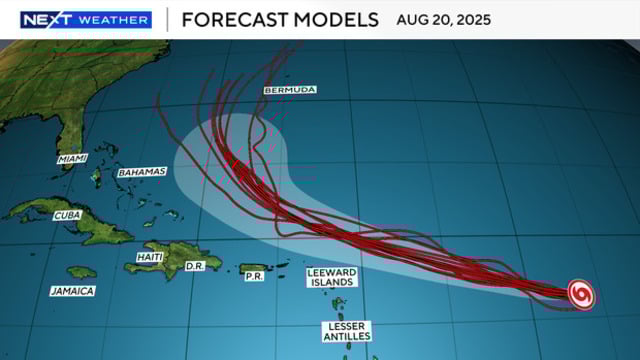
Currently tracking west or just south of west, Erin is projected to shift toward the west-northwest as it nears the Leeward Islands. A weakening high-pressure system to the north should help steer the storm north of both the islands and Puerto Rico.
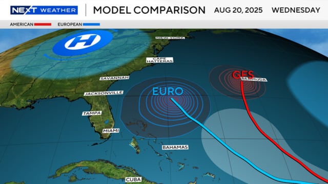
Forecast model
Projected path of tropical storm Erin
Although Erin’s center is expected to remain north, parts of the Leeward Islands and Puerto Rico could see periods of rain and strong winds on Saturday.
As it moves past the region, the storm is forecast to keep strengthening.
Sunday and Monday will be critical for tracking Erin’s path.
“A potential major hurricane at a lower latitude to our east moving northwest is always something to be concerned about, even if it is forecast to turn,” said meteorologist Dave Warren.
Forecasted storm’s path
Forecast models have consistently shown Erin making a northward turn on Monday and Tuesday as it sits directly east of Miami.
Currently, the western edge of the forecast cone remains east of the Bahamas, roughly 500 miles off South Florida’s coast.
Even if Erin slows or edges slightly farther west, projections still indicate a turn to the north and eventually northeast.
Uncertainty remains
There is still some uncertainty about Erin’s potential impacts on the Mid-Atlantic and Northeast, as a few western forecast tracks bring the storm close to the northern U.S. coast. For South Florida, however, the turn north is expected well before the system approaches the shoreline.
Hurricane Hunter aircraft are set to investigate Erin, gathering valuable data from inside and around the storm. This information will help refine both the intensity and track forecasts.
Residents in South Florida should remain vigilant for any significant shifts in Erin’s projected path over the coming days.
The National Hurricane Center will continue to release updated forecast tracks every six hours—at 5 a.m., 11 a.m., 5 p.m., and 11 p.m.
Follow Weather 365 to update storm Erin information and track the latest model trends.
Related post

What States Have The Most Wildfires? Surprising Facts And Statistics

Texas Flash Flooding: Uncovering the Causes Behind the Devastation

0 Comment
Leave a comment
Your email address will not be published. Required fields are marked *