

Tropical Storm Dexter Develops in Atlantic, Triggering More Weather Systems
Tropical Storm Dexter formed over the weekend a few hundred miles off the Carolina coast. Meteorologists warn of additional potential storm development in the coming days and weeks, including systems that could form near the United States.
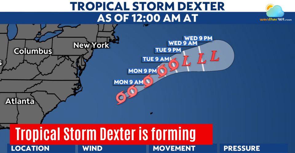
Tropical Storm Dexter
Tropical Storm Dexter formed
Tropical Storm Dexter developed from a low-pressure system along a stalled front off the southern Atlantic coast.
It is the same weather front responsible for flash flooding in the Mid-Atlantic on Thursday and parts of the Southeast on Friday and into the weekend.
By early this week, Dexter was located several hundred miles northeast of Bermuda, sparing the islands from a direct hit.
The storm mainly poses a risk to shipping and cruise operations as it tracks northeastward into cooler North Atlantic waters, where it is expected to lose its tropical characteristics later this week.
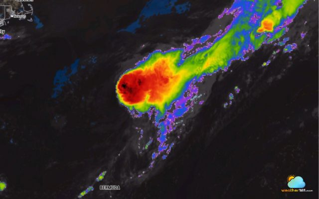
Image of tropical storm Dexter on Tues morning, Aug 5, 2025
It is forecasted that Dexter, combined with easterly breezes from high pressure over the Northeast, will create rough surf and strong rip currents along the Atlantic coastline from Florida to Massachusetts.
Bermuda will also experience choppy seas and rough surf.
Looking ahead, Dexter could reach the northern British Isles or Iceland this weekend as a tropical rainstorm, bringing gusty winds and rough seas to the region.
Next tropical depression threat
A new tropical depression or storm could form just off the southern Atlantic coast before the end of this week.
The same stalled front that helped develop Tropical Storm Dexter remains over the region, fueling showers and thunderstorms along the warm waters of the Gulf Stream.
Over time, these storms could organize and form a tropical circulation in the nearby Atlantic.
Unlike Dexter, this system’s steering breezes are expected to be different, resembling the track of Tropical Storm Chatall from a month ago.
Regardless of whether a tropical system officially forms, heavy rain is forecast across parts of the Southeast, driven by the lingering front.
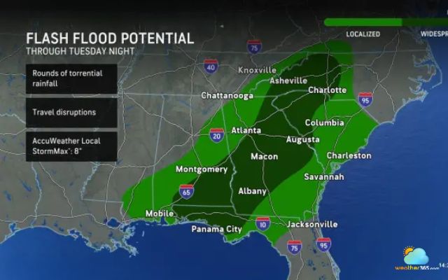
By late week and into the weekend, any developing low-pressure area could push gusty thunderstorms and downpours into the Carolinas.
Even without a named storm, this weather pattern may disrupt outdoor plans and travel.
If tropical development does occur and moves inland, there is potential for flash flooding in parts of the Carolinas, Georgia, and Virginia.
Tropical wave in the Gulf, Atlantic
A tropical wave moving west-northwest across the northern Caribbean islands this week is expected to enter the Gulf of Mexico early next week, where it has a low chance of developing into a tropical depression or storm.
Meanwhile, another strong tropical wave is about to move off the coast of Africa and has a high potential to develop into a tropical depression or storm later this week or early next week.
Forecasters say it could become a long-track tropical storm or hurricane, depending on the strength and position of high pressure near Bermuda and jet stream patterns over the eastern U.S.
If the high weakens, the storm may turn north and avoid the U.S. and northern Caribbean islands.
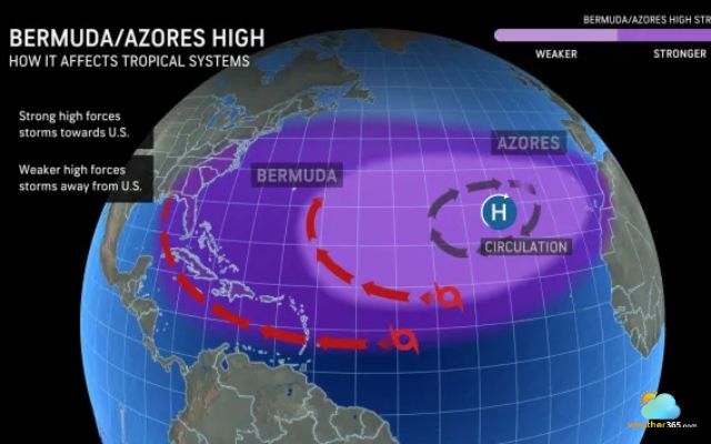
If it remains strong, the storm could track closer to the U.S. by mid-month. The next two storm names for the 2025 Atlantic hurricane season are Erin and Fernand.
As the peak of tropical activity approaches, coastal U.S. residents and Caribbean travelers are urged to monitor Atlantic hurricane developments closely.
>>>>> Stay tuned for weather forecast with Weather365 <<<<<
Related post

0 Comment
Leave a comment
Your email address will not be published. Required fields are marked *