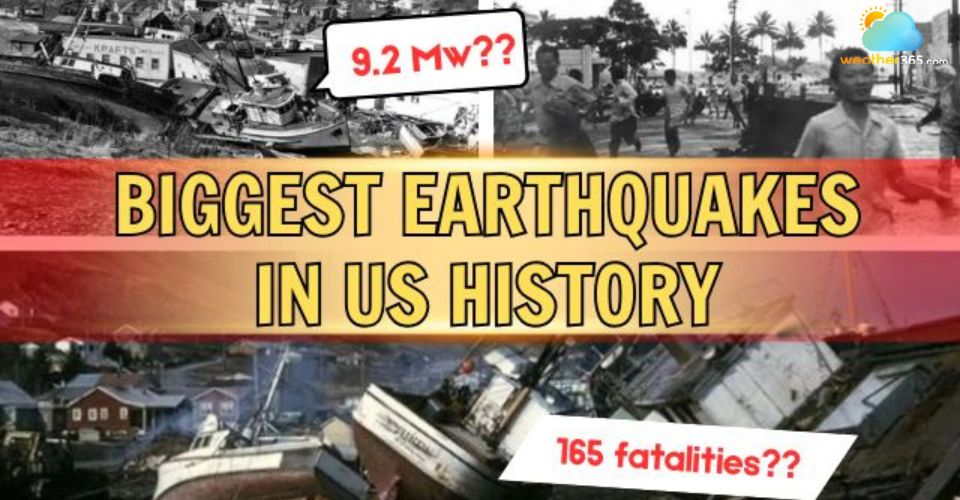
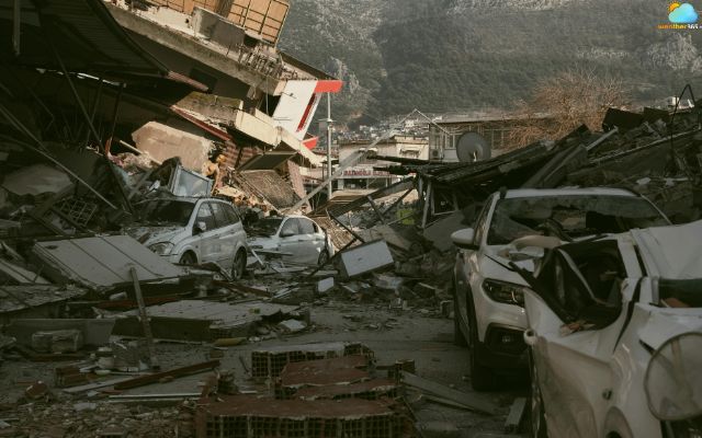
Biggest Earthquakes In US History: Top 5 Most Powerful Quakes
What are the biggest earthquakes in US history, and how do they reshape both land and lives? These massive quakes not only shook the ground but also changed communities, triggered tsunamis, and caused devastating impacts. Now, let’s dive in to discover the top 5 biggest earthquakes and see what they left behind!
Biggest Earthquakes In US History
- Top 5 Biggest Earthquakes in US History
- 1964 Alaska Earthquake
- The 1700 Cascadia Earthquake
- 1965 Rat Islands Earthquake
- 1946 Aleutian Islands Earthquake
- 1957 Andreanof Islands Earthquake
- States have the highest earthquake risk
- Southern Alaska
- California
- Hawaii
- How Often Do Earthquakes Occur
- What can we learn from those earthquakes
- Structural Integrity
- Urban Planning and Land Use Regulation
- Community and Personal Preparedness
- Effective Response and Recovery
Top 5 Biggest Earthquakes in US History
The United States has experienced some of the most powerful earthquakes in recorded history.
These events were not only intense in magnitude but also caused significant changes to landscapes and communities.
Below, we explore the top five biggest earthquakes, their magnitude, impacts, and key facts. To understand how these numbers and energy levels are mathematically calculated by scientists, you can read our guide on the Earthquake Magnitude Scale.
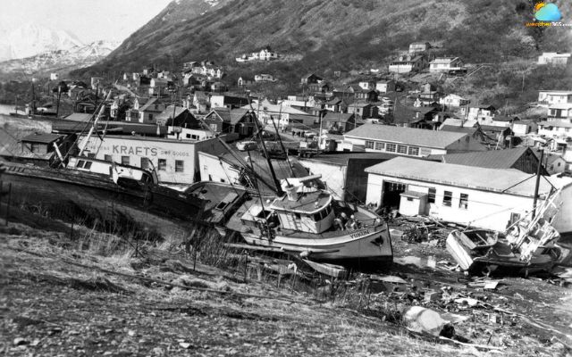
1964 Alaska Earthquake
Date: March 27, 1964
Location: Prince William Sound, Alaska
Magnitude: 9.2
On March 27, 1964, the Prince William Sound region in Alaska experienced a catastrophic earthquake with a magnitude of 9.2, making it the largest ever recorded in North America and ranking second among the largest earthquakes in the world.
The rupture occurred approximately 25 kilometers beneath the surface, with the epicenter located near College Fiord.
The quake lasted about four and a half minutes, producing violent shaking, landslides, and a powerful tsunami that devastated nearby coastal areas.
Thousands of buildings were damaged, and entire communities had to be rebuilt. This event not only highlighted the destructive potential of megathrust earthquakes but also emphasized the need for earthquake-resistant construction.
What Was The biggest Earthquake In Us History
The 1700 Cascadia Earthquake
Date: January 26, 1700
Location: West Coast of North America
Magnitude: Estimated 8.7-9.2
The 1700 Cascadia earthquake struck the west coast of North America on the evening of January 26.
With an estimated magnitude between 8.7 and 9.2, the quake occurred along the Cascadia subduction zone, causing a fault rupture of roughly 1,000 kilometers.
The movement of the earth’s crust triggered a tsunami that reached Japan, recording its enormous power even centuries later.
Although no written records exist from the American side, geological evidence and Japanese historical accounts reveal its severity.
This earthquake serves as a reminder of the ongoing seismic risk in the Pacific Northwest and the critical need for monitoring and preparedness strategies.
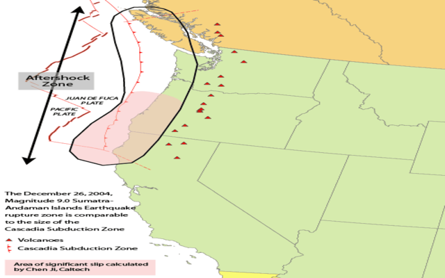
Map showing Cascadia subduction zone
Source: The United States Geological Survey
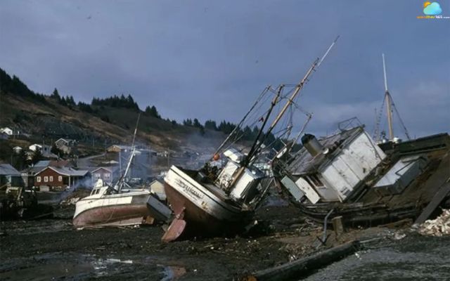
1965 Rat Islands Earthquake
Date: February 4, 1965 (local time: February 3, 19:01)
Location: Rat Islands, Alaska
Magnitude: 8.7
The Rat Islands earthquake occurred on February 4, 1965, in Alaska at 05:01 UTC. With a magnitude of 8.7, it produced a tsunami nearly ten meters high on Shemya Island.
Despite its intensity, the earthquake caused minimal damage due to the remote location of the Aleutian Islands.
Scientists studied this event extensively to understand the mechanics of subduction zone earthquakes and tsunami generation.
It demonstrated that even earthquakes far from populated areas can still produce significant waves.
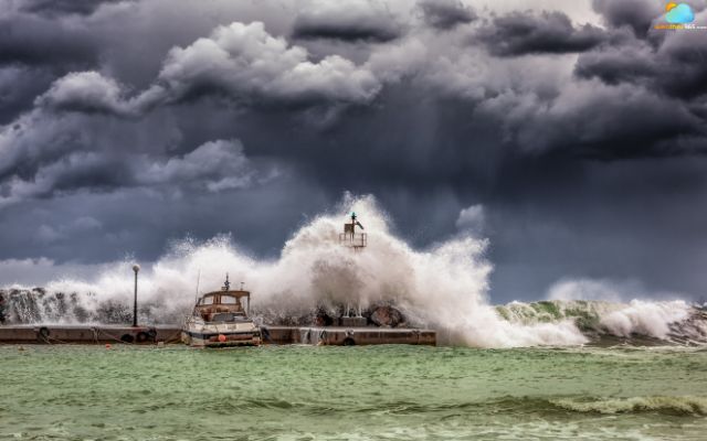
Earthquakes also cause tsunami to occur
1946 Aleutian Islands Earthquake
Date: April 1, 1946
Location: Aleutian Islands, Alaska
Magnitude: 7.8
On April 1, 1946, the Aleutian Islands of Alaska were struck by a magnitude 7.8 earthquake. The epicenter was located at 52.8° N, 163.5° W, with a focal depth of 25 kilometers.
This quake triggered a deadly tsunami that traveled across the Pacific, took the lives of more than 165 people in Hawaii, and caused over $26 million in damages, equivalent to several hundred million today.
The 1946 earthquake emphasized the need for better coastal warning systems and preparedness measures.
It also marked a turning point in tsunami monitoring in the Pacific, influencing how governments and scientists approach early warning systems.

Aleutian Islands Earthquake took the lives of more than 165 people
1957 Andreanof Islands Earthquake
Date: March 9, 1957, 04:22 local time
Location: Aleutian Trench, Alaska
Magnitude: 8,6
The Andreanof Islands earthquake struck on March 9, 1957, at 04:22 local time, with an estimated magnitude of 8.6.
Occurring along the Aleutian Trench, a convergent plate boundary, the quake caused significant displacement of the seafloor, generating tsunamis that affected nearby islands.
Although casualties were limited, the property damage reached approximately $5 million at the time, equivalent to nearly $56 million today.
Andreanof Islands Earthquake in 1957
States have the highest earthquake risk
Many US states lie along the Pacific Ring of Fire, making them highly vulnerable to earthquakes. This tectonic zone stretches across the Pacific Ocean and produces most of the world’s seismic activity.
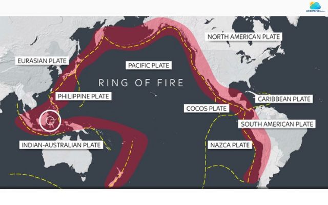
The Ring of Fire is the most vulnerable region to earthquakes
If you are curious about other regions where earthquakes are most likely to occur, drop by our full guide on what causes an earthquakes.
In the US; Alaska, California, and Hawaii consistently rank as the states with the highest risk of experience frequent tremors and occasional major quakess.
Southern Alaska
Alaska is the most seismically active state in the US and one of the most active regions globally. Each year, this state experiences thousands of earthquakes, many exceeding magnitude 7.0.
The reason is that the Pacific Plate subducts beneath the North American Plate.
This process builds up enormous stress in the Earth’s crust, which, when suddenly released, causes frequent and powerful earthquakes.
To learn more about how tectonic movements trigger earthquakes, check out our article What causes an earthquake.
In 1964, a magnitude 9.2 earthquake struck Prince William Sound, causing massive destruction and becoming the largest earthquake ever recorded in North America.
Due to its frequent earthquakes occurence, Alaska’s community is often in extremely need for strict building codes and disaster preparedness.
Alaska ranks as the most seismically active state in the US
California
California’s earthquake risk stems from several major fault systems, especially the San Andreas Fault, where the Pacific and North American Plates meet.
This area has a long history of destructive earthquakes, including the famous 1906 San Francisco earthquake.
In recent years, even moderate quakes, such as the 4.3 magnitude event near Berkeley in September 2025, cause widespread tremors throughout the Bay Area. These frequent, smaller shakes highlight the daily difference between earthquake and tremor experienced by residents in active fault zones.
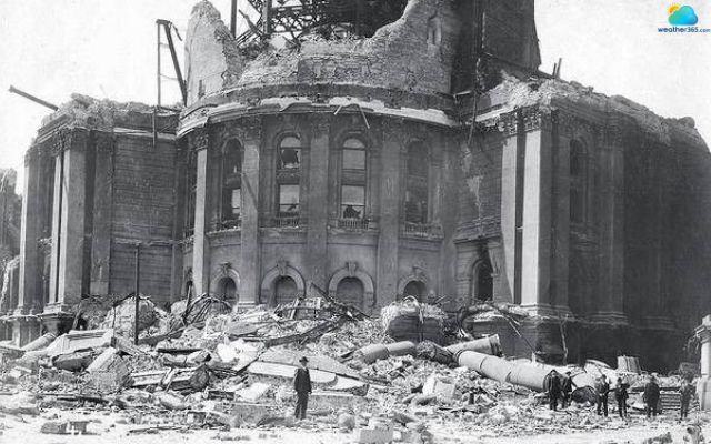
Aftermath of an earthquake in San Francisco
Hawaii
Hawaii’s earthquakes are primarily caused by volcanic activity rather than plate boundary movement.
The shifting of magma beneath the islands can trigger tremors, some of which reach damaging levels.
In 2018, during the Kīlauea eruption, hundreds of earthquakes were triggered as magma shifted beneath the island.
Several of these quakes exceeded magnitude 5, causing significant damage to homes, roads, and infrastructure in nearby communities.
While these quakes are generally smaller than those in Alaska or California, they can still impact communities near volcanoes.
Therefore, monitoring volcanic activity and maintaining early-warning systems are critical to minimizing risks in Hawaii’s unique seismic environment.
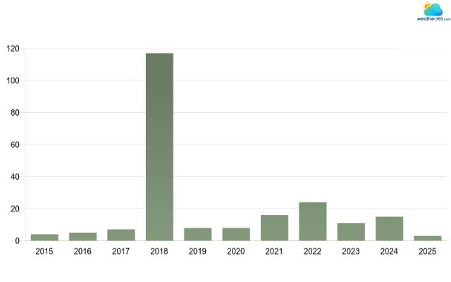
Annual earthquakes of magnitude 4+ occurring within 300 km (186 mi) of Hawaii
Source: EarthquakeList.org
How Often Do Earthquakes Occur
Earthquakes are a constant presence on Earth, with the National Earthquake Information Center detecting approximately 12,000 to 14,000 earthquakes annually worldwide.
However, only a fraction of these are strong enough to be felt by people.
Globally, it is estimated that around 500,000 earthquakes occur each year, though many are too small to be noticed. In the United States, the frequency varies by region.
For instance, Alaska experiences thousands of earthquakes annually, many of which are minor tremors. In contrast, the eastern US sees far fewer seismic events.
In addition, most earthquakes are minor, with magnitudes less than 3.0, and often go unnoticed. Stronger earthquakes, those with magnitudes of 4.0 or higher, are less common but can cause significant shaking and potential damage.
Major earthquakes, with magnitudes of 7.0 or higher, occur about 15 times per year globally.
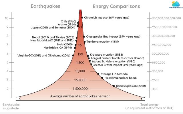
Earthquakes with higher magnitudes are often less common
Source: The Iris Consortium
What can we learn from those earthquakes
Earthquakes are among nature's most unpredictable and destructive events.
However, by studying past earthquakes, we can uncover valuable lessons that help mitigate future risks.
Structural Integrity
One of the most important lessons from past earthquakes is the need for strong, resilient buildings.
Countries in seismic zones, such as Japan and Chile, continuously update and enforce building codes to ensure structures can withstand powerful shaking. Older buildings are particularly vulnerable, so retrofitting is critical.
This process strengthens foundations and uses flexible materials, like steel, that can absorb seismic energy without collapsing.
Modern engineering innovations further enhance resilience.
Technologies such as base isolation systems separate a building from its foundation using shock absorbers, while ductile materials allow structures to bend and sway rather than break.
Investing in structural integrity can dramatically reduce casualties and property damage during earthquakes.

Resilient buildings are in extreme importance in case of earthquakes
Urban Planning and Land Use Regulation
Effective urban planning and thoughtful land use can significantly lower earthquake risks.
Governments now rely on hazard mapping to identify areas prone to earthquakes, guiding safe construction and development.
Disaster-resilient urban design emphasizes open spaces, proper road networks, and accessible evacuation routes.
Buildings such as soft-story structures, with weak ground floors, are often reinforced or replaced to prevent collapse during tremors.
By integrating earthquake risk into city planning, communities can reduce both human and economic losses when quakes strike.

Effective urban planning can lower earthquake risks
Community and Personal Preparedness
Advance preparation is crucial.
In the 2015 Nepal earthquake, despite its devastating impact, the loss of life was significantly reduced due to early warning systems and public awareness campaigns.
Simple protocols like “Drop, Cover, and Hold On” can save lives by protecting people from falling debris during a quake.
Families are encouraged to maintain emergency kits with food, water, first-aid supplies, and other essentials for several days.
Public awareness campaigns, drills, and education programs help residents know how to respond before, during, and after earthquakes.
Learning how to safely shut off gas and water lines and having a family communication plan ensures faster recovery.
For detailed guidance, readers can refer to our comprehensive earthquake safety tips and preparedness guide.

Prepare for earthquakes is the best way to minimize risks
For detailed guidance, readers can refer to our comprehensive earthquake preparedness guide.
Effective Response and Recovery
Even the best-prepared communities need an efficient response and recovery system after an earthquake.
Quick coordination between local authorities, emergency responders, and aid organizations can save lives and reduce damage.
For example, after the 2011 Tōhoku earthquake in Japan, local and national agencies worked together to evacuate hundreds of thousands of people and provide immediate aid, which minimized casualties despite the massive tsunami.
Recovery plans should prioritize restoring utilities, clearing debris, and providing shelter and medical care to affected residents.
Lessons from past disasters show that empowering local responders and integrating them into recovery efforts improves efficiency.
Combining rapid response with long-term planning ensures communities can rebuild stronger and minimize the long-term impact of future earthquakes.

Emergency responders can save lives and reduce damage
Conclusion
Looking back at the biggest earthquakes in US history, it is clear how powerful they can be, and how they left lasting marks on both land and our society. Understanding their causes and impacts allows us to strengthen infrastructure, improve safety protocols, and prepare communities for future events. By learning from the past, we can reduce damage and save lives when the next major earthquake occurs. To monitor active seismic fault lines, track real-time weather anomalies, or receive instant emergency alerts, access our Live Weather Radar.
Frequently Asked Questions (FAQs)
Related post

TOP 10 Largest Earthquakes In The World: Stats, Destruction & Aftermath

Earthquake Preparedness: Easy Steps to Minimize Risk and Stay Safe

0 Comment
Leave a comment
Your email address will not be published. Required fields are marked *